TopoQuest Logo
Do you find TopoQuest useful?
Help keep TopoQuest running and adding new maps/features by donating!
Bitcoin:  19c7KJd3qBynnjoSw5npx9KScwjBe4ifkT
Litecoin:  LXs6TkuXGGXo1vDsWCkWVdjQX94eUKd6ui
Home View Maps Find Maps Find Places Resources & Links


Indian Spring, Oregon Topographic Map

USGS Map Title: Indian Spring, OR
USGS Map MRC: 45120C4
DRG (GeoTIFF) Download: o45120c4.tif


Neighboring USGS Topographic Map Quads:


  Harmony, OR  
45120D5
 

  Esau Canyon, OR  
45120D4
 

  Devils Backbone, OR  
45120D3
 

  Indian Cove, OR  
45120C5
 

  Indian Spring, OR  
45120C4
 

  Igo Butte, OR  
45120C3
 

  Horseshoe Bend, OR  
45120B5
 

  Shoestring Ridge, OR  
45120B4
 

  Schott Canyon, OR  
45120B3


Map MRC Location:

N46°
W121°
N46°
W120°
H8 H7 H6 H5 H4 H3 H2 H1
G8 G7 G6 G5 G4 G3 G2 G1
F8 F7 F6 F5 F4 F3 F2 F1
E8 E7 E6 E5 E4 E3 E2 E1
D8 D7 D6 D5 D4 D3 D2 D1
C8 C7 C6 C5 C4 C3 C2 C1
B8 B7 B6 B5 B4 B3 B2 B1
A8 A7 A6 A5 A4 A3 A2 A1
N45°
W121°
N45°
W120°

Indian Spring, OR USGS 1:24K Topographic Map Preview:
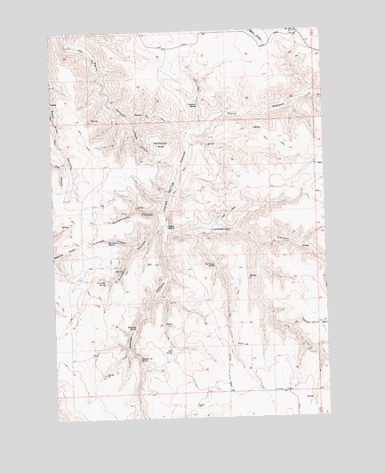
Indian Spring, OR USGS Topographic Map
Click on map above to begin viewing in our Map Viewer.

This topographic map contains these locations and features:
Feature Name Type Latitude Longitude GNIS ID View Map
Ajax (historical)LocaleN45.3693°W120.4470°1161742View Map
Ajax Post Office (historical)Post OfficeN45.3693°W120.4470°1164813View Map
Ajax School (historical)SchoolN45.3746°W120.4303°1638469View Map
Bell Camp SpringSpringN45.2992°W120.4273°1117489View Map
Buck HollowValleyN45.3707°W120.4914°1118194View Map
Cook SpringSpringN45.2714°W120.4479°1119222View Map
Dipping Vat SpringSpringN45.2692°W120.4625°1119953View Map
Elbow CanyonValleyN45.3440°W120.4637°1120421View Map
Fitzwater CanyonValleyN45.3112°W120.4506°1120796View Map
Fitzwater SpringSpringN45.2946°W120.4775°1120797View Map
Freezeout CanyonValleyN45.3415°W120.4331°1131064View Map
Freezeout SpringSpringN45.3507°W120.4334°1120977View Map
Indian SpringSpringN45.3118°W120.4484°1144077View Map
Indian Spring CanyonValleyN45.3418°W120.4417°1122246View Map
Juniper CanyonValleyN45.3112°W120.4503°1122576View Map
Lamberson CanyonValleyN45.3112°W120.4506°1122922View Map
McIntosh SpringSpringN45.2794°W120.4642°1123974View Map
Pumphouse CanyonValleyN45.3162°W120.4520°1125703View Map
Rattlesnake ButteSummitN45.3385°W120.4509°1125818View Map
Simmons CanyonValleyN45.3054°W120.4648°1126979View Map
Simmons SpringSpringN45.3076°W120.4757°1126983View Map
Willows SpringSpringN45.3347°W120.4088°1161607View Map

Note: Coordinates in the location and feature list above are referenced to NAD83 datum.


Copyright (C) 2008-2025 Ryan Niemi / Sunset Dynamics ... All Rights Reserved