TopoQuest Logo
Do you find TopoQuest useful?
Help keep TopoQuest running and adding new maps/features by donating!
Bitcoin:  19c7KJd3qBynnjoSw5npx9KScwjBe4ifkT
Litecoin:  LXs6TkuXGGXo1vDsWCkWVdjQX94eUKd6ui
Home View Maps Find Maps Find Places Resources & Links


Bee Bayou, Louisiana Topographic Map

USGS Map Title: Bee Bayou, LA
USGS Map MRC: 32091D6
DRG (GeoTIFF) Download: o32091d6.tif


Neighboring USGS Topographic Map Quads:


  Irwin Lake, LA  
32091E7
 

  Whitney Island South, LA  
32091E6
 

  Congo Creek, LA  
32091E5
 

  Rayville, LA  
32091D7
 

  Bee Bayou, LA  
32091D6
 

  Dunn, LA  
32091D5
 

  Mangham, LA  
32091C7
 

  Baskinton, LA  
32091C6
 

  Lamar, LA  
32091C5


Map MRC Location:

N33°
W92°
N33°
W91°
H8 H7 H6 H5 H4 H3 H2 H1
G8 G7 G6 G5 G4 G3 G2 G1
F8 F7 F6 F5 F4 F3 F2 F1
E8 E7 E6 E5 E4 E3 E2 E1
D8 D7 D6 D5 D4 D3 D2 D1
C8 C7 C6 C5 C4 C3 C2 C1
B8 B7 B6 B5 B4 B3 B2 B1
A8 A7 A6 A5 A4 A3 A2 A1
N32°
W92°
N32°
W91°

Bee Bayou, LA USGS 1:24K Topographic Map Preview:
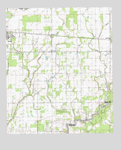
Bee Bayou, LA USGS Topographic Map
Click on map above to begin viewing in our Map Viewer.

This topographic map contains these locations and features:
Feature Name Type Latitude Longitude GNIS ID View Map
Bee BayouPopulated PlaceN32.4732°W91.6957°542971View Map
Big Creek Gas FieldOilfieldN32.4015°W91.7471°553639View Map
Burns BayouStreamN32.4154°W91.7240°533565View Map
Cow BayouStreamN32.3843°W91.6765°534203View Map
Cypress CreekStreamN32.4251°W91.6321°534362View Map
Dehlco Oil FieldOilfieldN32.3843°W91.7360°534476View Map
East Fork CreekStreamN32.4860°W91.6273°534716View Map
Grace ChurchChurchN32.4396°W91.6626°535301View Map
Greer CemeteryCemeteryN32.4185°W91.7171°535419View Map
Holly RidgePopulated PlaceN32.4676°W91.6268°543304View Map
Holly Ridge ChurchChurchN32.4649°W91.6448°535730View Map
Holly Ridge ChurchChurchN32.4857°W91.6437°535731View Map
Holly Ridge Elementary SchoolSchoolN32.4689°W91.6277°548681View Map
Hunters ChapelChurchN32.4351°W91.6601°535866View Map
Hurricane BayouStreamN32.4551°W91.6390°535868View Map
Interchange 141CrossingN32.4563°W91.6962°541500View Map
Interchange 145CrossingN32.4560°W91.6276°541501View Map
KTJC-FM (Rayville)TowerN32.4643°W91.6529°1633104View Map
Mixon ChurchChurchN32.3824°W91.6287°537171View Map
Parish Governing Authority District 4CivilN32.4727°W91.6297°1930028View Map
Parish Governing Authority District 5CivilN32.4493°W91.7468°1930093View Map
Rayville High SchoolSchoolN32.4668°W91.7469°548687View Map
Rayville Junior High SchoolSchoolN32.4649°W91.7469°548688View Map
Richardson Medical CenterHospitalN32.4631°W91.7492°548690View Map
Riverfield Academy SchoolSchoolN32.4817°W91.7490°2462930View Map
Saint Peter ChurchChurchN32.4640°W91.6965°539051View Map
Squires HeliportAirportN32.4299°W91.7243°1632926View Map
Sunflower CemeteryCemeteryN32.3882°W91.6346°539725View Map
Ward TwoCivilN32.4815°W91.7232°545188View Map
West Fork CreekStreamN32.4860°W91.6279°540318View Map
Zebedee ChurchChurchN32.4063°W91.6848°540586View Map

Note: Coordinates in the location and feature list above are referenced to NAD83 datum.


Copyright (C) 2008-2025 Ryan Niemi / Sunset Dynamics ... All Rights Reserved