TopoQuest Logo
Do you find TopoQuest useful?
Help keep TopoQuest running and adding new maps/features by donating!
Bitcoin:  19c7KJd3qBynnjoSw5npx9KScwjBe4ifkT
Litecoin:  LXs6TkuXGGXo1vDsWCkWVdjQX94eUKd6ui
Home View Maps Find Maps Find Places Resources & Links


Islandton, South Carolina Topographic Map

USGS Map Title: Islandton, SC
USGS Map MRC: 32080H8
DRG (GeoTIFF) Download: o32080h8.tif


Neighboring USGS Topographic Map Quads:


  Ehrhardt, SC  
33081A1
 

  Lodge, SC  
33080A8
 

  Williams, SC  
33080A7
 

  Crocketville, SC  
32081H1
 

  Islandton, SC  
32080H8
 

  Sniders Crossroads, SC  
32080H7
 

  Hampton, SC  
32081G1
 

  Cummings, SC  
32080G8
 

  Black Creek, SC  
32080G7


Map MRC Location:

N33°
W81°
N33°
W80°
H8 H7 H6 H5 H4 H3 H2 H1
G8 G7 G6 G5 G4 G3 G2 G1
F8 F7 F6 F5 F4 F3 F2 F1
E8 E7 E6 E5 E4 E3 E2 E1
D8 D7 D6 D5 D4 D3 D2 D1
C8 C7 C6 C5 C4 C3 C2 C1
B8 B7 B6 B5 B4 B3 B2 B1
A8 A7 A6 A5 A4 A3 A2 A1
N32°
W81°
N32°
W80°

Islandton, SC USGS 1:24K Topographic Map Preview:
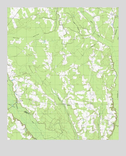
Islandton, SC USGS Topographic Map
Click on map above to begin viewing in our Map Viewer.

This topographic map contains these locations and features:
Feature Name Type Latitude Longitude GNIS ID View Map
Adnah CemeteryCemeteryN32.8929°W80.8865°1240540View Map
Adnah ChurchChurchN32.8932°W80.8868°1244850View Map
Cedar BranchStreamN32.9766°W80.9045°1221424View Map
Cedar Branch SchoolSchoolN32.9702°W80.9193°1221429View Map
Colleton Fire Department Station 10BuildingN32.9145°W80.8890°2368127View Map
Colleton Fire Department Station 15BuildingN32.9164°W80.9329°2368282View Map
Cross SwampSwampN32.9563°W80.9640°1221852View Map
Cross Swamp CemeteryCemeteryN32.9715°W80.9409°1240606View Map
Cross Swamp ChurchChurchN32.9716°W80.9420°1247438View Map
Cross Swamp SchoolSchoolN32.9596°W80.9548°1221853View Map
Deep Creek ChurchChurchN32.8991°W80.8976°1221979View Map
Deep Creek School (historical)SchoolN32.8985°W80.8970°1240607View Map
IslandtonPopulated PlaceN32.9091°W80.9354°1223470View Map
Islandton Census Designated PlaceCensusN32.9093°W80.9359°2629833View Map
Islandton Post OfficePost OfficeN32.9086°W80.9270°2489845View Map
Islandton School (historical)SchoolN32.9107°W80.9465°1240652View Map
Lodge DivisionCivilN32.9751°W80.9503°1938335View Map
Moselle SwampSwampN32.9727°W80.9798°1224666View Map
New Hope ChurchChurchN32.9029°W80.9076°1240686View Map
New Hope Church (historical)ChurchN32.8982°W80.9054°1240687View Map
Oakgrove School (historical)SchoolN32.9235°W80.9623°1249925View Map
Pemel ChurchChurchN32.8882°W80.8815°1225353View Map
Peniel Baptist ChurchChurchN32.8877°W80.8809°1240701View Map
Peniel CemeteryCemeteryN32.8871°W80.8809°1240702View Map
Piney Grove SchoolSchoolN32.9593°W80.9826°1225500View Map
Rice Patch Christian ChurchChurchN32.9091°W80.9357°1240720View Map
Rice Path CemeteryCemeteryN32.9093°W80.9359°1240719View Map
Ricepatch School (historical)SchoolN32.9146°W80.9307°1250365View Map
Rum GullyStreamN32.9688°W80.8984°1226068View Map
Rum Gully SchoolSchoolN32.9332°W80.9068°1250487View Map
Saint John ChurchChurchN32.8777°W80.9790°1250532View Map
Saint John School (historical)SchoolN32.8777°W80.9790°1232205View Map
Toby BluffCliffN32.9121°W80.9893°1248884View Map
Tobys BluffPopulated PlaceN32.9110°W80.9890°1231864View Map
Tobys Bluff ChurchChurchN32.9191°W80.9604°1227160View Map
Tobys Bluff School (historical)SchoolN32.9191°W80.9601°1240765View Map
Whippy SwampStreamN32.9063°W80.9893°1251405View Map
Willow SwampStreamN32.9635°W80.8840°1227631View Map

Note: Coordinates in the location and feature list above are referenced to NAD83 datum.


Copyright (C) 2008-2025 Ryan Niemi / Sunset Dynamics ... All Rights Reserved