TopoQuest Logo
Do you find TopoQuest useful?
Help keep TopoQuest running and adding new maps/features by donating!
Bitcoin:  19c7KJd3qBynnjoSw5npx9KScwjBe4ifkT
Litecoin:  LXs6TkuXGGXo1vDsWCkWVdjQX94eUKd6ui
Home View Maps Find Maps Find Places Resources & Links


Ehrhardt, South Carolina Topographic Map

USGS Map Title: Ehrhardt, SC
USGS Map MRC: 33081A1
DRG (GeoTIFF) Download: o33081a1.tif


Neighboring USGS Topographic Map Quads:


  Olar, SC  
33081B2
 

  Clear Pond, SC  
33081B1
 

  Tony Hill Bay, SC  
33080B8
 

  Sycamore, SC  
33081A2
 

  Ehrhardt, SC  
33081A1
 

  Lodge, SC  
33080A8
 

  Fairfax, SC  
32081H2
 

  Crocketville, SC  
32081H1
 

  Islandton, SC  
32080H8


Map MRC Location:

N34°
W82°
N34°
W81°
H8 H7 H6 H5 H4 H3 H2 H1
G8 G7 G6 G5 G4 G3 G2 G1
F8 F7 F6 F5 F4 F3 F2 F1
E8 E7 E6 E5 E4 E3 E2 E1
D8 D7 D6 D5 D4 D3 D2 D1
C8 C7 C6 C5 C4 C3 C2 C1
B8 B7 B6 B5 B4 B3 B2 B1
A8 A7 A6 A5 A4 A3 A2 A1
N33°
W82°
N33°
W81°

Ehrhardt, SC USGS 1:24K Topographic Map Preview:
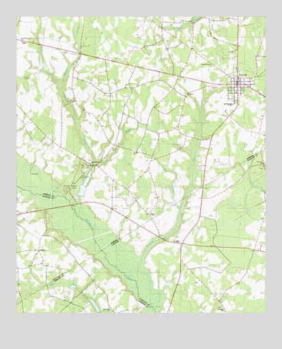
Ehrhardt, SC USGS Topographic Map
Click on map above to begin viewing in our Map Viewer.

This topographic map contains these locations and features:
Feature Name Type Latitude Longitude GNIS ID View Map
Bamberg Rescue Squad Medic 2BuildingN33.0944°W81.0135°2368444View Map
Big BranchStreamN33.0638°W81.0857°1220669View Map
Brants Pond Dam D-2819DamN33.1035°W81.1132°1239658View Map
Breland CemeteryCemeteryN33.0990°W81.1209°1230880View Map
Broxton Bridge Plantation AirportAirportN33.0089°W81.0481°1251890View Map
Cherry Grove ChurchChurchN33.0018°W81.0779°1251702View Map
Cherry Grove SchoolSchoolN33.0018°W81.0779°1221541View Map
Church BranchStreamN33.0960°W81.1029°1230887View Map
Coggins School (historical)SchoolN33.1107°W81.0379°1230892View Map
EhrhardtPopulated PlaceN33.0968°W81.0143°1222249View Map
Ehrhardt AirportAirportN33.0900°W81.0120°1251889View Map
Ehrhardt Baptist ChurchChurchN33.0952°W81.0159°1230907View Map
Ehrhardt CemeteryCemeteryN33.0952°W81.1107°1230908View Map
Ehrhardt DivisionCivilN33.1130°W81.0020°1938258View Map
Ehrhardt Elementary SchoolSchoolN33.0933°W81.0143°1230909View Map
Ehrhardt Fire DepartmentBuildingN33.0944°W81.0134°2368321View Map
Ehrhardt Memorial Lutheran ChurchChurchN33.0965°W81.0173°1230910View Map
Ehrhardt Police DepartmentBuildingN33.0931°W81.0146°2334915View Map
Ehrhardt Post OfficePost OfficeN33.0969°W81.0136°1252069View Map
Ehrhardt United Methodist ChurchChurchN33.0921°W81.0137°1230911View Map
Emily Kearse Community House (historical)BuildingN33.1096°W81.0957°1230912View Map
Folk SchoolSchoolN33.0274°W81.0254°1222474View Map
Friendship ChurchChurchN33.0024°W81.0212°1240623View Map
Friendship SchoolSchoolN33.0027°W81.0212°1222582View Map
Gins Branch School (historical)SchoolN33.1149°W81.1015°1230923View Map
Haywood SchoolSchoolN33.1249°W81.0315°1223101View Map
Hiers Pond Dam D-2822DamN33.0518°W81.0915°1239668View Map
Hog BranchStreamN33.0513°W81.1187°1223208View Map
Jenny PondReservoirN33.0033°W81.0854°1238775View Map
JennysPopulated PlaceN33.0263°W81.1137°1233132View Map
Kearse - Barbham CemeteryCemeteryN33.1146°W81.1226°1230940View Map
Kearse CemeteryCemeteryN33.1102°W81.1015°1230941View Map
Kearse ChapelChurchN33.1140°W81.1234°1246222View Map
Lake Hi-Ki Pen Dam D-2817DamN33.0668°W81.0832°1239670View Map
Lewis Butler SchoolSchoolN33.0882°W81.0173°1230944View Map
Long BranchStreamN33.0446°W81.0420°1224112View Map
Meadow BranchStreamN33.0960°W81.1029°1230953View Map
Mount Pleasant Lutheran ChurchChurchN33.0918°W81.0390°1224777View Map
Mount Zion ChurchChurchN33.0243°W81.1237°1224818View Map
Oak Grove ChurchChurchN33.0627°W81.0015°1225098View Map
Red Oak School (historical)SchoolN33.0529°W81.0690°1230971View Map
Rivers BridgeBridgeN33.0457°W81.0976°1230973View Map
Rivers Bridge State ParkParkN33.0565°W81.0954°1230974View Map
Rizer CemeteryCemeteryN33.0468°W81.0390°1240722View Map
Rizers ChapelChurchN33.0421°W81.0576°1225905View Map
Saint Johns Baptist ChurchChurchN33.0679°W81.0665°1230977View Map
Saint Lukes ChurchChurchN33.1104°W81.0145°1250572View Map
Savannah CreekStreamN33.0202°W81.0662°1226418View Map
Savannah Creek Baptist ChurchChurchN33.1049°W81.0273°1250798View Map
South Carolina Noname 25018 D-2596 DamDamN33.0035°W81.0865°1238774View Map
Stony Bay SchoolSchoolN33.1232°W81.0587°1226913View Map
Threemile BranchStreamN33.0413°W81.0932°1251169View Map
Threemile Creek ChurchChurchN33.0638°W81.0887°1246620View Map
Town of EhrhardtCivilN33.0985°W81.0138°2406429View Map
Union School (historical)SchoolN33.0254°W81.1243°1233177View Map
Wesley CemeteryCemeteryN33.0321°W81.0451°1240779View Map
Wesley ChapelChurchN33.0304°W81.0470°1251363View Map

Note: Coordinates in the location and feature list above are referenced to NAD83 datum.


Copyright (C) 2008-2024 Ryan Niemi / Sunset Dynamics ... All Rights Reserved