TopoQuest Logo
Do you find TopoQuest useful?
Help keep TopoQuest running and adding new maps/features by donating!
Bitcoin:  19c7KJd3qBynnjoSw5npx9KScwjBe4ifkT
Litecoin:  LXs6TkuXGGXo1vDsWCkWVdjQX94eUKd6ui
Home View Maps Find Maps Find Places Resources & Links


Jabez, Kentucky Topographic Map

USGS Map Title: Jabez, KY
USGS Map MRC: 36084H8
DRG (GeoTIFF) Download: o36084h8.tif


Neighboring USGS Topographic Map Quads:


  Russell Springs, KY  
37085A1
 

  Eli, KY  
37084A8
 

  Faubush, KY  
37084A7
 

  Jamestown, KY  
36085H1
 

  Jabez, KY  
36084H8
 

  Mill Springs, KY  
36084H7
 

  Cumberland City, KY  
36085G1
 

  Parnell, KY  
36084G8
 

  Monticello, KY  
36084G7


Map MRC Location:

N37°
W85°
N37°
W84°
H8 H7 H6 H5 H4 H3 H2 H1
G8 G7 G6 G5 G4 G3 G2 G1
F8 F7 F6 F5 F4 F3 F2 F1
E8 E7 E6 E5 E4 E3 E2 E1
D8 D7 D6 D5 D4 D3 D2 D1
C8 C7 C6 C5 C4 C3 C2 C1
B8 B7 B6 B5 B4 B3 B2 B1
A8 A7 A6 A5 A4 A3 A2 A1
N36°
W85°
N36°
W84°

Jabez, KY USGS 1:24K Topographic Map Preview:
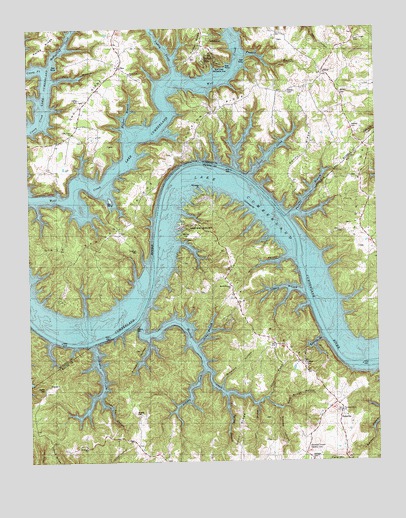
Jabez, KY USGS Topographic Map
Click on map above to begin viewing in our Map Viewer.

This topographic map contains these locations and features:
Feature Name Type Latitude Longitude GNIS ID View Map
Alexander CemeteryCemeteryN36.8938°W84.8938°2568731View Map
Boones HollowValleyN36.8903°W84.9098°487700View Map
Bradford HollowValleyN36.8966°W84.9312°487791View Map
Camp Earl WallaceLocaleN36.9434°W84.9413°488696View Map
Caney ForkStreamN36.9884°W84.9925°488859View Map
Cave Springs RidgeRidgeN36.9395°W84.9705°489143View Map
Cedar Crest Post Office (historical)Post OfficeN36.9568°W84.8804°2568764View Map
Coffey CemeteryCemeteryN36.9028°W84.9011°489774View Map
Coffey CemeteryCemeteryN36.9795°W84.9811°489775View Map
Coleman CemeteryCemeteryN36.9359°W84.9608°489820View Map
Dean BranchStreamN36.8912°W84.9188°490736View Map
Dean RidgeRidgeN36.8845°W84.9252°490739View Map
Decker CemeteryCemeteryN36.8962°W84.9944°490748View Map
Denny RidgeRidgeN36.9642°W84.9005°490819View Map
Difficulty CreekStreamN36.9087°W84.9772°490892View Map
Dudley CreekStreamN36.9859°W84.9472°491258View Map
EadsvillePopulated PlaceN36.8881°W84.8888°507897View Map
Granny CreekStreamN36.9012°W84.9374°493110View Map
Harmon CreekStreamN36.9159°W84.9591°493754View Map
Hatfield CemeteryCemeteryN36.9712°W84.8833°493863View Map
Hughes BranchStreamN36.9695°W84.9630°494744View Map
Indian HillsPopulated PlaceN36.9928°W84.9336°494964View Map
JabezPopulated PlaceN36.9870°W84.8936°508325View Map
Jack HollowValleyN36.9851°W84.9901°495076View Map
Jacks BranchStreamN36.9090°W84.9402°495083View Map
Johns BranchStreamN36.8909°W84.9074°495340View Map
Kenneth BranchStreamN36.9106°W84.8947°495655View Map
Kennett HollowValleyN36.9101°W84.9574°495656View Map
Lake Valley ChurchChurchN36.9701°W84.9841°495920View Map
Lick CreekStreamN36.9570°W84.9202°496466View Map
Linney BranchStreamN36.9242°W84.9013°496591View Map
McFarland CreekStreamN36.9884°W84.9925°497850View Map
Memorial Turners GardensCemeteryN36.8790°W84.9005°498064View Map
Military CemeteryCemeteryN36.9812°W84.9063°498190View Map
Mill HollowValleyN36.9339°W84.9065°498282View Map
Miller HollowValleyN36.9082°W84.8975°498344View Map
Mount Hope ChurchChurchN36.8790°W84.9797°498756View Map
Mount Pleasant ChurchChurchN36.9253°W84.9272°498834View Map
Norfleet CemeteryCemeteryN36.9395°W84.9433°499518View Map
Oil Spring BranchStreamN36.8942°W84.9297°499784View Map
OnoPopulated PlaceN36.9887°W84.9666°508752View Map
Ono RidgeRidgeN36.9806°W84.9775°499940View Map
Parmleys Grove ChurchChurchN36.8895°W84.8883°500212View Map
Polston RidgeRidgeN36.9762°W84.9319°501023View Map
Puckett BranchStreamN36.9926°W84.9216°501408View Map
Ramsey PointCapeN36.9542°W84.9377°501563View Map
Rock Bridge HollowValleyN36.8908°W84.9077°502107View Map
Rogers CemeteryCemeteryN36.9134°W84.9619°502274View Map
Russell CemeteryCemeteryN36.8890°W84.9616°502508View Map
Square Oak ChurchChurchN36.9870°W84.9630°504199View Map
Stringer CemeteryCemeteryN36.8756°W84.8994°504584View Map
Thomas BranchStreamN36.9456°W84.9063°505155View Map
Toler RidgeRidgeN36.9167°W84.9199°505323View Map
Turkey Pen HollowValleyN36.8934°W84.9748°505619View Map
Union RidgeRidgeN36.9506°W84.8813°505811View Map
Walters CemeteryCemeteryN36.9809°W84.8872°506196View Map
Wolf Creek Recreation AreaParkN36.9887°W84.9316°507007View Map

Note: Coordinates in the location and feature list above are referenced to NAD83 datum.


Copyright (C) 2008-2025 Ryan Niemi / Sunset Dynamics ... All Rights Reserved