TopoQuest Logo
Do you find TopoQuest useful?
Help keep TopoQuest running and adding new maps/features by donating!
Bitcoin:  19c7KJd3qBynnjoSw5npx9KScwjBe4ifkT
Litecoin:  LXs6TkuXGGXo1vDsWCkWVdjQX94eUKd6ui
Home View Maps Find Maps Find Places Resources & Links


Russell Springs, Kentucky Topographic Map

USGS Map Title: Russell Springs, KY
USGS Map MRC: 37085A1
DRG (GeoTIFF) Download: o37085a1.tif


Neighboring USGS Topographic Map Quads:


  Knifley, KY  
37085B2
 

  Dunnville, KY  
37085B1
 

  Phil, KY  
37084B8
 

  Montpelier, KY  
37085A2
 

  Russell Springs, KY  
37085A1
 

  Eli, KY  
37084A8
 

  Creelsboro, KY  
36085H2
 

  Jamestown, KY  
36085H1
 

  Jabez, KY  
36084H8


Map MRC Location:

N38°
W86°
N38°
W85°
H8 H7 H6 H5 H4 H3 H2 H1
G8 G7 G6 G5 G4 G3 G2 G1
F8 F7 F6 F5 F4 F3 F2 F1
E8 E7 E6 E5 E4 E3 E2 E1
D8 D7 D6 D5 D4 D3 D2 D1
C8 C7 C6 C5 C4 C3 C2 C1
B8 B7 B6 B5 B4 B3 B2 B1
A8 A7 A6 A5 A4 A3 A2 A1
N37°
W86°
N37°
W85°

Russell Springs, KY USGS 1:24K Topographic Map Preview:
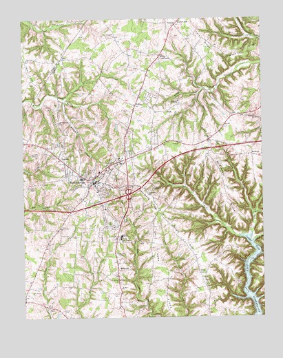
Russell Springs, KY USGS Topographic Map
Click on map above to begin viewing in our Map Viewer.

This topographic map contains these locations and features:
Feature Name Type Latitude Longitude GNIS ID View Map
Beckham RidgeRidgeN37.0770°W85.1052°486645View Map
Beckham Ridge ChurchChurchN37.0815°W85.1058°486646View Map
Bernard Church of GodChurchN37.0190°W85.0305°486908View Map
Bernard RidgeRidgeN37.0331°W85.0416°486909View Map
Bob BranchStreamN37.0323°W85.0041°487598View Map
City of Russell SpringsCivilN37.0509°W85.0774°2404656View Map
Clear ForkStreamN37.0351°W85.0063°489623View Map
Clear Spring ChurchChurchN37.0515°W85.0602°489646View Map
Clear Spring RidgeRidgeN37.0501°W85.0619°489648View Map
Coffey Hill Friendship ChurchChurchN37.0541°W85.0572°492938View Map
Concord RidgeRidgeN37.0098°W85.0250°489941View Map
EstoPopulated PlaceN37.0042°W85.1108°507950View Map
Fairview Baptist ChurchChurchN37.0748°W85.0275°491912View Map
Foley RidgeRidgeN37.1156°W85.0300°492291View Map
FonthillPopulated PlaceN37.0840°W85.0036°508020View Map
Free Union Separate Baptist ChurchChurchN37.1078°W85.1222°492493View Map
French Valley Methodist ChurchChurchN37.0373°W85.1061°492524View Map
Half Acre RidgeRidgeN37.0170°W85.0525°493559View Map
Hillcrest CemeteryCemeteryN37.0176°W85.0755°494260View Map
HorntownPopulated PlaceN37.0678°W85.0055°508281View Map
Hudson CreekStreamN37.0915°W85.1033°494725View Map
HumblePopulated PlaceN37.0887°W85.0666°508294View Map
JerichoPopulated PlaceN37.0865°W85.0491°508335View Map
Jones BranchStreamN37.0931°W85.0330°495452View Map
Lucenda CemeteryCemeteryN37.0245°W85.0411°497330View Map
McClendon RidgeRidgeN37.0545°W85.0191°497786View Map
MiddletownPopulated PlaceN37.0206°W85.0761°508597View Map
Mill CreekStreamN37.0428°W85.0052°498257View Map
Mount Hope ChurchChurchN37.0120°W85.0744°498757View Map
Mount Olive CreekStreamN37.0915°W85.1033°498797View Map
New Friendship ChurchChurchN37.0903°W85.0438°499317View Map
Phelps CemeteryCemeteryN37.0031°W85.1044°500514View Map
Poplar Grove ChurchChurchN37.1220°W85.0466°501112View Map
RoyvillePopulated PlaceN37.0667°W85.1058°502444View Map
Russell County AirportAirportN37.0069°W85.1024°517483View Map
Russell County Ambulance ServiceBuildingN37.0577°W85.0687°2719137View Map
Russell County HospitalHospitalN37.0578°W85.0675°2660396View Map
Russell SpringsPopulated PlaceN37.0562°W85.0886°502532View Map
Russell Springs DivisionCivilN37.0787°W85.0684°1937229View Map
Russell Springs Fire DepartmentBuildingN37.0575°W85.0894°2637020View Map
Russell Springs Police DepartmentBuildingN37.0573°W85.0892°2767570View Map
SanoPopulated PlaceN37.1084°W85.1036°509013View Map
Sycamore FlatPopulated PlaceN37.1240°W85.0433°509176View Map
Webb RidgeRidgeN37.1106°W85.0113°506336View Map
Webbs Cross RoadsPopulated PlaceN37.1092°W85.0536°509329View Map
Welfare Baptist ChurchChurchN37.0151°W85.0761°506366View Map
Whites ChapelChurchN37.0542°W85.1216°506668View Map
WIDS-AM (Russell Springs)TowerN37.0951°W85.0847°517895View Map
Williams CreekStreamN37.0903°W85.1036°506814View Map
WJKY-AM (Jamestown)TowerN37.0253°W85.0730°517836View Map
WJRS-FM (Jamestown)TowerN37.0253°W85.0730°517964View Map

Note: Coordinates in the location and feature list above are referenced to NAD83 datum.


Copyright (C) 2008-2024 Ryan Niemi / Sunset Dynamics ... All Rights Reserved