TopoQuest Logo
Do you find TopoQuest useful?
Help keep TopoQuest running and adding new maps/features by donating!
Bitcoin:  19c7KJd3qBynnjoSw5npx9KScwjBe4ifkT
Litecoin:  LXs6TkuXGGXo1vDsWCkWVdjQX94eUKd6ui
Home View Maps Find Maps Find Places Resources & Links


Jamestown, Kentucky Topographic Map

USGS Map Title: Jamestown, KY
USGS Map MRC: 36085H1
DRG (GeoTIFF) Download: o36085h1.tif


Neighboring USGS Topographic Map Quads:


  Montpelier, KY  
37085A2
 

  Russell Springs, KY  
37085A1
 

  Eli, KY  
37084A8
 

  Creelsboro, KY  
36085H2
 

  Jamestown, KY  
36085H1
 

  Jabez, KY  
36084H8
 

  Wolf Creek Dam, KY  
36085G2
 

  Cumberland City, KY  
36085G1
 

  Parnell, KY  
36084G8


Map MRC Location:

N37°
W86°
N37°
W85°
H8 H7 H6 H5 H4 H3 H2 H1
G8 G7 G6 G5 G4 G3 G2 G1
F8 F7 F6 F5 F4 F3 F2 F1
E8 E7 E6 E5 E4 E3 E2 E1
D8 D7 D6 D5 D4 D3 D2 D1
C8 C7 C6 C5 C4 C3 C2 C1
B8 B7 B6 B5 B4 B3 B2 B1
A8 A7 A6 A5 A4 A3 A2 A1
N36°
W86°
N36°
W85°

Jamestown, KY USGS 1:24K Topographic Map Preview:
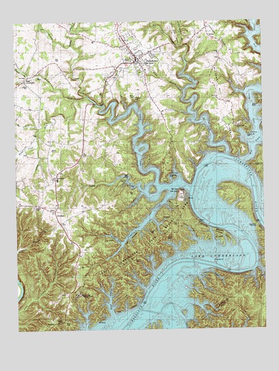
Jamestown, KY USGS Topographic Map
Click on map above to begin viewing in our Map Viewer.

This topographic map contains these locations and features:
Feature Name Type Latitude Longitude GNIS ID View Map
Baugh BranchStreamN36.8817°W85.0772°486475View Map
Bells ChapelChurchN36.9395°W85.1019°486819View Map
Bethel ChurchChurchN36.9542°W85.1138°486964View Map
Bethel CreekStreamN36.9501°W85.1150°486995View Map
Big Lily CreekStreamN36.9895°W85.0413°487217View Map
Blakey BranchStreamN36.9773°W85.1180°487448View Map
Buckett BranchStreamN36.8987°W85.0280°488246View Map
Caney CreekStreamN36.9548°W85.0027°488845View Map
City of JamestownCivilN36.9951°W85.0683°2404788View Map
Clifty CreekStreamN36.9323°W85.0527°489696View Map
Concord ChurchChurchN36.9867°W85.0216°489926View Map
FreedomPopulated PlaceN36.9228°W85.1055°508037View Map
Greasy CreekStreamN36.9328°W85.0383°493235View Map
Highway MissionChurchN36.8784°W85.1025°494233View Map
JamestownPopulated PlaceN36.9848°W85.0630°495165View Map
Jamestown DivisionCivilN36.9265°W85.0686°1937078View Map
Jamestown DockLocaleN36.9381°W85.0472°495166View Map
Jamestown Fire DepartmentBuildingN36.9846°W85.0644°2636380View Map
Jamestown Police DepartmentBuildingN36.9861°W85.0637°2767748View Map
Jobbes ForkStreamN36.9695°W85.0883°495283View Map
KarlusPopulated PlaceN36.9940°W85.0263°508368View Map
Keen CemeteryCemeteryN36.9303°W85.0652°495590View Map
Lake Cumberland State ParkParkN36.9101°W85.0622°495913View Map
Lawless CemeteryCemeteryN36.9739°W85.1177°496069View Map
Lily CreekStreamN36.9465°W85.0183°496537View Map
Little Lily CreekStreamN36.9895°W85.0413°496787View Map
Lowgap IslandIslandN36.9128°W85.0222°497323View Map
Moores ForkStreamN36.9684°W85.0941°498565View Map
Moores SchoolSchoolN36.9781°W85.1186°498567View Map
Mount Vernon CreekStreamN36.9567°W85.1127°498900View Map
Murray CemeteryCemeteryN36.9481°W85.1066°499121View Map
Otter CreekStreamN36.8751°W85.0400°500027View Map
Perkins CreekStreamN36.9901°W85.0961°500417View Map
Pig Pen PointCapeN36.8987°W85.0033°487226View Map
Pleasant Hill Common ChurchChurchN36.9576°W85.0127°500854View Map
Pleasant Hill DockLocaleN36.9540°W85.0077°500874View Map
Pumpkin CreekStreamN36.9312°W85.0461°501430View Map
Right Fork Pumpkin CreekStreamN36.9103°W85.0716°501917View Map
Rose CrossroadsPopulated PlaceN36.9759°W85.1205°508971View Map
RowenaPopulated PlaceN36.8778°W85.1063°508982View Map
Russell CountyCivilN36.9910°W85.0587°516950View Map
Russell County Sheriff's OfficeBuildingN36.9839°W85.0627°2767530View Map
School House HollowValleyN36.9106°W85.0336°503049View Map
Scotts Chapel ChurchChurchN36.9503°W85.0463°503111View Map
SewelltonPopulated PlaceN36.9362°W85.1050°509036View Map
State DockLocaleN36.9312°W85.0436°504275View Map
Town BranchStreamN36.9720°W85.0402°505377View Map
Wolf CreekStreamN36.9431°W85.0100°506997View Map
Worldridge SchoolSchoolN36.9462°W85.0908°507151View Map
Wright HollowValleyN36.9197°W85.0558°507167View Map

Note: Coordinates in the location and feature list above are referenced to NAD83 datum.


Copyright (C) 2008-2024 Ryan Niemi / Sunset Dynamics ... All Rights Reserved