TopoQuest Logo
Do you find TopoQuest useful?
Help keep TopoQuest running and adding new maps/features by donating!
Bitcoin:  19c7KJd3qBynnjoSw5npx9KScwjBe4ifkT
Litecoin:  LXs6TkuXGGXo1vDsWCkWVdjQX94eUKd6ui
Home View Maps Find Maps Find Places Resources & Links


Jacksboro, Texas Topographic Map

USGS Map Title: Jacksboro, TX
USGS Map MRC: 33098B2
DRG (GeoTIFF) Download: o33098b2.tif


Neighboring USGS Topographic Map Quads:


  Lynn Creek, TX  
33098C3
 

  Johnson Lake, TX  
33098C2
 

  Cundiff, TX  
33098C1
 

  Senate, TX  
33098B3
 

  Jacksboro, TX  
33098B2
 

  Jacksboro NE, TX  
33098B1
 

  Long Hollow, TX  
33098A3
 

  Bartons Chapel, TX  
33098A2
 

  Perrin, TX  
33098A1


Map MRC Location:

N34°
W99°
N34°
W98°
H8 H7 H6 H5 H4 H3 H2 H1
G8 G7 G6 G5 G4 G3 G2 G1
F8 F7 F6 F5 F4 F3 F2 F1
E8 E7 E6 E5 E4 E3 E2 E1
D8 D7 D6 D5 D4 D3 D2 D1
C8 C7 C6 C5 C4 C3 C2 C1
B8 B7 B6 B5 B4 B3 B2 B1
A8 A7 A6 A5 A4 A3 A2 A1
N33°
W99°
N33°
W98°

Jacksboro, TX USGS 1:24K Topographic Map Preview:
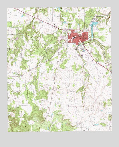
Jacksboro, TX USGS Topographic Map
Click on map above to begin viewing in our Map Viewer.

This topographic map contains these locations and features:
Feature Name Type Latitude Longitude GNIS ID View Map
Bibleway ChapelChurchN33.2159°W98.1598°1330550View Map
City of JacksboroCivilN33.2235°W98.1588°2410127View Map
College HillSummitN33.2173°W98.1742°1333107View Map
Dark Corner CemeteryCemeteryN33.1709°W98.2287°1334047View Map
Faith Community HospitalHospitalN33.2251°W98.1700°2015794View Map
Fort Richardson (historical)MilitaryN33.2072°W98.1639°1384135View Map
Fort Richardson SpringSpringN33.2084°W98.1753°1998544View Map
Fort Richardson State Historical ParkParkN33.2101°W98.1612°2031870View Map
Fort Richardson State Historical ParkParkN33.2032°W98.1620°2028313View Map
Fort Richardson State Historical Park TrailTrailN33.2071°W98.1642°2032734View Map
Halls BranchStreamN33.2162°W98.1481°1337262View Map
Jack CountyCivilN33.2335°W98.1725°1383904View Map
Jack County Constable's OfficeBuildingN33.2444°W98.1560°2750731View Map
Jack County Constable's OfficeBuildingN33.2188°W98.1581°2750558View Map
Jack County JailBuildingN33.2445°W98.1559°2738721View Map
Jack County Rural Fire DepartmentBuildingN33.2196°W98.1583°2551233View Map
Jack County Sheriff's OfficeBuildingN33.2444°W98.1562°2750337View Map
JacksboroPopulated PlaceN33.2184°W98.1587°1338568View Map
Jacksboro Alternative SchoolSchoolN33.2176°W98.1709°2006201View Map
Jacksboro City HallBuildingN33.2185°W98.1595°2753543View Map
Jacksboro Elementary SchoolSchoolN33.2179°W98.1692°2006202View Map
Jacksboro High SchoolSchoolN33.2176°W98.1709°2006203View Map
Jacksboro Municipal AirportAirportN33.2309°W98.1452°1386946View Map
Jacksboro Police DepartmentBuildingN33.2180°W98.1579°2750604View Map
Jacksboro Post OfficePost OfficeN33.2174°W98.1577°2731604View Map
Jacksboro Volunteer Fire DepartmentBuildingN33.2202°W98.1578°2552115View Map
James W Knox HouseBuildingN33.2223°W98.1614°2030955View Map
John Lowrance Middle SchoolSchoolN33.2179°W98.1692°2006204View Map
Lake JacksboroReservoirN33.2340°W98.1464°1338569View Map
Lake Jacksboro DamDamN33.2351°W98.1403°1860536View Map
Linnie Shelton SchoolSchoolN33.2140°W98.1628°1339986View Map
Lost Creek ReservoirReservoirN33.2416°W98.1321°2574529View Map
Oakwood CemeteryCemeteryN33.2268°W98.1573°1343047View Map
One Sixty Four Place AirportAirportN33.1261°W98.2291°1386947View Map
Park SpringSpringN33.2015°W98.1609°1998545View Map
Raper CemeteryCemeteryN33.1868°W98.2239°1344803View Map
Soil Conservation Service Site 19 DamDamN33.2201°W98.2370°1860532View Map
Soil Conservation Service Site 19 ReservoirReservoirN33.2186°W98.2388°1860533View Map
Soil Conservation Service Site 20 DamDamN33.2318°W98.2203°1860534View Map
Soil Conservation Service Site 20 ReservoirReservoirN33.2300°W98.2187°1860535View Map
Southwest Baptist ChurchChurchN33.2140°W98.1692°2020753View Map
Spillers BranchStreamN33.2101°W98.1659°1347655View Map
Steed Oil FieldOilfieldN33.1790°W98.2420°1347847View Map
Texas Department of Criminal Justice John R Lindsey State JailBuildingN33.2473°W98.1534°2738645View Map
Tiger StadiumParkN33.2176°W98.1709°2027622View Map

Note: Coordinates in the location and feature list above are referenced to NAD83 datum.


Copyright (C) 2008-2025 Ryan Niemi / Sunset Dynamics ... All Rights Reserved