TopoQuest Logo
Do you find TopoQuest useful?
Help keep TopoQuest running and adding new maps/features by donating!
Bitcoin:  19c7KJd3qBynnjoSw5npx9KScwjBe4ifkT
Litecoin:  LXs6TkuXGGXo1vDsWCkWVdjQX94eUKd6ui
Home View Maps Find Maps Find Places Resources & Links


Johnson Lake, Texas Topographic Map

USGS Map Title: Johnson Lake, TX
USGS Map MRC: 33098C2
DRG (GeoTIFF) Download: o33098c2.tif


Neighboring USGS Topographic Map Quads:


  Antelope, TX  
33098D3
 

  Postoak, TX  
33098D2
 

  Newport, TX  
33098D1
 

  Lynn Creek, TX  
33098C3
 

  Johnson Lake, TX  
33098C2
 

  Cundiff, TX  
33098C1
 

  Senate, TX  
33098B3
 

  Jacksboro, TX  
33098B2
 

  Jacksboro NE, TX  
33098B1


Map MRC Location:

N34°
W99°
N34°
W98°
H8 H7 H6 H5 H4 H3 H2 H1
G8 G7 G6 G5 G4 G3 G2 G1
F8 F7 F6 F5 F4 F3 F2 F1
E8 E7 E6 E5 E4 E3 E2 E1
D8 D7 D6 D5 D4 D3 D2 D1
C8 C7 C6 C5 C4 C3 C2 C1
B8 B7 B6 B5 B4 B3 B2 B1
A8 A7 A6 A5 A4 A3 A2 A1
N33°
W99°
N33°
W98°

Johnson Lake, TX USGS 1:24K Topographic Map Preview:
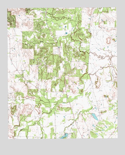
Johnson Lake, TX USGS Topographic Map
Click on map above to begin viewing in our Map Viewer.

This topographic map contains these locations and features:
Feature Name Type Latitude Longitude GNIS ID View Map
Big Cleveland CreekStreamN33.3182°W98.1345°1372534View Map
Brown CemeteryCemeteryN33.3729°W98.1292°1352967View Map
Crooked CreekStreamN33.3265°W98.1323°1355383View Map
Flag Springs CreekStreamN33.3476°W98.1778°1357412View Map
Graves CemeteryCemeteryN33.2937°W98.2487°1358337View Map
Jacksboro DivisionCivilN33.3061°W98.1557°1938862View Map
Johnson LakeReservoirN33.2543°W98.1856°1374311View Map
Jones CreekStreamN33.3629°W98.1750°1360394View Map
Little Cleveland CreekStreamN33.3118°W98.1495°1374565View Map
North CreekStreamN33.2859°W98.1881°1375154View Map
Patton CemeteryCemeteryN33.2951°W98.1903°1364885View Map
Prunty LakeReservoirN33.2973°W98.2423°1865049View Map
Prunty Lake DamDamN33.2968°W98.2420°1865048View Map
Pursley BranchStreamN33.2732°W98.2125°1375585View Map
Soil Conservation Service Site 18 DamDamN33.2534°W98.1853°1860574View Map
Soil Conservation Service Site 18 ReservoirReservoirN33.2519°W98.1863°1860575View Map
Soil Conservation Service Site 21 DamDamN33.2584°W98.2370°1860576View Map
Soil Conservation Service Site 21 ReservoirReservoirN33.2572°W98.2386°1860577View Map
Worthington LakeReservoirN33.2709°W98.1513°1860579View Map
Worthington Lake DamDamN33.2734°W98.1537°1860578View Map
Worthington Lake Number 2ReservoirN33.2622°W98.1529°1865041View Map
Worthington Lake Number 2 DamDamN33.2634°W98.1520°1865040View Map
Worthington Lake Number 3ReservoirN33.2895°W98.1380°1865045View Map
Worthington Lake Number 3 DamDamN33.2901°W98.1370°1865044View Map

Note: Coordinates in the location and feature list above are referenced to NAD83 datum.


Copyright (C) 2008-2025 Ryan Niemi / Sunset Dynamics ... All Rights Reserved