TopoQuest Logo
Do you find TopoQuest useful?
Help keep TopoQuest running and adding new maps/features by donating!
Bitcoin:  19c7KJd3qBynnjoSw5npx9KScwjBe4ifkT
Litecoin:  LXs6TkuXGGXo1vDsWCkWVdjQX94eUKd6ui
Home View Maps Find Maps Find Places Resources & Links


Senate, Texas Topographic Map

USGS Map Title: Senate, TX
USGS Map MRC: 33098B3
DRG (GeoTIFF) Download: o33098b3.tif


Neighboring USGS Topographic Map Quads:


  Markley, TX  
33098C4
 

  Lynn Creek, TX  
33098C3
 

  Johnson Lake, TX  
33098C2
 

  Bryson, TX  
33098B4
 

  Senate, TX  
33098B3
 

  Jacksboro, TX  
33098B2
 

  Ross Mountain, TX  
33098A4
 

  Long Hollow, TX  
33098A3
 

  Bartons Chapel, TX  
33098A2


Map MRC Location:

N34°
W99°
N34°
W98°
H8 H7 H6 H5 H4 H3 H2 H1
G8 G7 G6 G5 G4 G3 G2 G1
F8 F7 F6 F5 F4 F3 F2 F1
E8 E7 E6 E5 E4 E3 E2 E1
D8 D7 D6 D5 D4 D3 D2 D1
C8 C7 C6 C5 C4 C3 C2 C1
B8 B7 B6 B5 B4 B3 B2 B1
A8 A7 A6 A5 A4 A3 A2 A1
N33°
W99°
N33°
W98°

Senate, TX USGS 1:24K Topographic Map Preview:
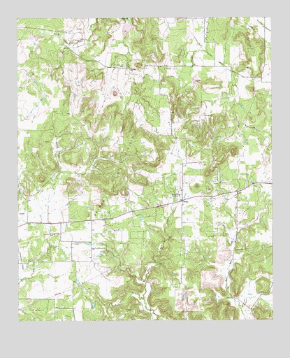
Senate, TX USGS Topographic Map
Click on map above to begin viewing in our Map Viewer.

This topographic map contains these locations and features:
Feature Name Type Latitude Longitude GNIS ID View Map
Bethany ChurchChurchN33.2287°W98.3189°1330477View Map
Bob TownPopulated PlaceN33.1657°W98.3389°2034965View Map
Bryson DivisionCivilN33.1423°W98.3478°1938575View Map
Bryson Oil FieldOilfieldN33.1898°W98.3250°1331473View Map
Cottonwood CemeteryCemeteryN33.1573°W98.3481°1333433View Map
Dearing LakeReservoirN33.2258°W98.2877°1865003View Map
Dearing Lake DamDamN33.2251°W98.2870°1865002View Map
Mountain Home Missionary ChurchChurchN33.1773°W98.2945°1342169View Map
Rhodes LakeReservoirN33.1334°W98.2920°1865007View Map
Rhodes Lake DamDamN33.1334°W98.2920°1865006View Map
SenatePopulated PlaceN33.1743°W98.2942°1379052View Map
Soil Conservation Service Site 22 DamDamN33.2234°W98.2903°1860540View Map
Soil Conservation Service Site 22 ReservoirReservoirN33.2234°W98.2903°1860541View Map
Soil Conservation Service Site 23 DamDamN33.2484°W98.2703°1862717View Map
Soil Conservation Service Site 23 ReservoirReservoirN33.2469°W98.2694°1862718View Map
Soil Conservation Service Site 24 DamDamN33.2418°W98.3670°1860542View Map
Soil Conservation Service Site 24 ReservoirReservoirN33.2423°W98.3685°1860543View Map
Soil Conservation Service Site 25 DamDamN33.2368°W98.3520°1860544View Map
Soil Conservation Service Site 25 ReservoirReservoirN33.2368°W98.3520°1860545View Map
Soil Conservation Service Site 28a DamDamN33.2468°W98.3220°1860546View Map
Soil Conservation Service Site 28a ReservoirReservoirN33.2458°W98.3209°1860547View Map
Tater HillSummitN33.2237°W98.2870°1348273View Map
Winn Hill CemeteryCemeteryN33.2304°W98.3223°1350420View Map

Note: Coordinates in the location and feature list above are referenced to NAD83 datum.


Copyright (C) 2008-2025 Ryan Niemi / Sunset Dynamics ... All Rights Reserved