TopoQuest Logo
Do you find TopoQuest useful?
Help keep TopoQuest running and adding new maps/features by donating!
Bitcoin:  19c7KJd3qBynnjoSw5npx9KScwjBe4ifkT
Litecoin:  LXs6TkuXGGXo1vDsWCkWVdjQX94eUKd6ui
Home View Maps Find Maps Find Places Resources & Links


Jamaica, Vermont Topographic Map

USGS Map Title: Jamaica, VT
USGS Map MRC: 43072A7
DRG (GeoTIFF) Download: o43072a7.tif


Neighboring USGS Topographic Map Quads:


  Peru, VT  
43072B8
 

  Londonderry, VT  
43072B7


  Stratton Mountain, VT  
43072A8
 

  Jamaica, VT  
43072A7


  Mount Snow, VT  
42072H8
 

  West Dover, VT  
42072H7


Map MRC Location:

N44°
W73°
N44°
W72°
H8 H7 H6 H5 H4 H3 H2 H1
G8 G7 G6 G5 G4 G3 G2 G1
F8 F7 F6 F5 F4 F3 F2 F1
E8 E7 E6 E5 E4 E3 E2 E1
D8 D7 D6 D5 D4 D3 D2 D1
C8 C7 C6 C5 C4 C3 C2 C1
B8 B7 B6 B5 B4 B3 B2 B1
A8 A7 A6 A5 A4 A3 A2 A1
N43°
W73°
N43°
W72°

Jamaica, VT USGS 1:24K Topographic Map Preview:
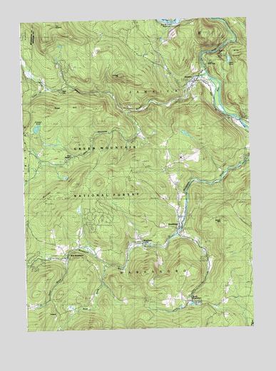
Jamaica, VT USGS Topographic Map
Click on map above to begin viewing in our Map Viewer.

This topographic map contains these locations and features:
Feature Name Type Latitude Longitude GNIS ID View Map
Adam PondLakeN43.1082°W72.7603°1460516View Map
Ball MountainSummitN43.1192°W72.7740°1460554View Map
Ball Mountain BrookStreamN43.1029°W72.7723°1460555View Map
Cobb BrookStreamN43.1242°W72.7651°1460736View Map
College HillSummitN43.1026°W72.8198°1460747View Map
Dover BrookStreamN43.0306°W72.8520°1460803View Map
Fairview CemeteryCemeteryN43.0385°W72.7879°1460859View Map
Forester PondLakeN43.0816°W72.8672°1460881View Map
JamaicaPopulated PlaceN43.1004°W72.7784°1461018View Map
Jamaica Fire DepartmentBuildingN43.0988°W72.7825°2121223View Map
Jamaica Memorial Free Public LibraryBuildingN43.0998°W72.7784°1921035View Map
Jamaica Post OfficePost OfficeN43.0999°W72.7813°1921036View Map
Jamaica State ParkParkN43.1109°W72.7712°1461713View Map
Jamaica Village SchoolSchoolN43.1041°W72.7752°1921034View Map
Kidder BrookStreamN43.0979°W72.8604°1461046View Map
Little Ball MountainSummitN43.1098°W72.7698°1921053View Map
Mundal HillSummitN43.0504°W72.8634°1461194View Map
Mundell - Bourne CemeteryCemeteryN43.1012°W72.8631°1921081View Map
North Branch Ball Mountain BrookStreamN43.0879°W72.8170°1461215View Map
Overlook TrailTrailN43.1062°W72.7690°1921106View Map
Pikes FallsPopulated PlaceN43.0970°W72.8551°1461274View Map
Pikes Falls CemeteryCemeteryN43.0967°W72.8554°1921112View Map
Pleasant View CemeteryCemeteryN43.1003°W72.7737°1461285View Map
PodunkPopulated PlaceN43.0087°W72.8587°1461289View Map
Railroad Bed TrailTrailN43.1156°W72.7559°1921126View Map
Robinson Dalewood CemeteryCemeteryN43.1064°W72.8547°1921135View Map
Sage HillSummitN43.0904°W72.8629°1461366View Map
Salmon HoleBendN43.1051°W72.7576°1921155View Map
Seventh Day Adventist Church CemeteryCemeteryN43.0989°W72.8507°1921168View Map
South Hill CemeteryCemeteryN43.0672°W72.7897°1461435View Map
South WardsboroPopulated PlaceN43.0115°W72.7834°1461451View Map
South Wardsboro CemeteryCemeteryN43.0104°W72.7842°1921183View Map
Stacey MountainSummitN43.0429°W72.7651°1461459View Map
The PinnacleSummitN43.1245°W72.8579°1461536View Map
Town of JamaicaCivilN43.1006°W72.7993°1462126View Map
Town of WardsboroCivilN43.0208°W72.8101°1462241View Map
Waite BrookStreamN43.0267°W72.8298°1461569View Map
WardsboroPopulated PlaceN43.0417°W72.7912°1461576View Map
Wardsboro CenterPopulated PlaceN43.0362°W72.8079°1461579View Map
Wardsboro Elementary SchoolSchoolN43.0483°W72.7873°2427589View Map
Wardsboro Fire DepartmentBuildingN43.0412°W72.7903°2121213View Map
Wardsboro Post OfficePost OfficeN43.0404°W72.7899°1921237View Map
West JamaicaPopulated PlaceN43.0684°W72.8515°1461593View Map
West Jamaica CemeteryCemeteryN43.0706°W72.8432°1921253View Map
West WardsboroPopulated PlaceN43.0295°W72.8526°1461598View Map
West Wardsboro CemeteryCemeteryN43.0334°W72.8476°1921264View Map
West Wardsboro Fire StationBuildingN43.0286°W72.8699°2121497View Map
West Wardsboro Post OfficePost OfficeN43.0335°W72.8469°1921265View Map
Wilder CemeteryCemeteryN43.1045°W72.8545°1921274View Map
Winhall Town ForestForestN43.1162°W72.8598°1921292View Map

Note: Coordinates in the location and feature list above are referenced to NAD83 datum.


Copyright (C) 2008-2025 Ryan Niemi / Sunset Dynamics ... All Rights Reserved