TopoQuest Logo
Do you find TopoQuest useful?
Help keep TopoQuest running and adding new maps/features by donating!
Bitcoin:  19c7KJd3qBynnjoSw5npx9KScwjBe4ifkT
Litecoin:  LXs6TkuXGGXo1vDsWCkWVdjQX94eUKd6ui
Home View Maps Find Maps Find Places Resources & Links


Londonderry, Vermont Topographic Map

USGS Map Title: Londonderry, VT
USGS Map MRC: 43072B7
DRG (GeoTIFF) Download: o43072b7.tif


Neighboring USGS Topographic Map Quads:


  Danby, VT  
43072C8
 

  Weston, VT  
43072C7
 

  Andover, VT  
43072C6
 

  Peru, VT  
43072B8
 

  Londonderry, VT  
43072B7


  Stratton Mountain, VT  
43072A8
 

  Jamaica, VT  
43072A7


Map MRC Location:

N44°
W73°
N44°
W72°
H8 H7 H6 H5 H4 H3 H2 H1
G8 G7 G6 G5 G4 G3 G2 G1
F8 F7 F6 F5 F4 F3 F2 F1
E8 E7 E6 E5 E4 E3 E2 E1
D8 D7 D6 D5 D4 D3 D2 D1
C8 C7 C6 C5 C4 C3 C2 C1
B8 B7 B6 B5 B4 B3 B2 B1
A8 A7 A6 A5 A4 A3 A2 A1
N43°
W73°
N43°
W72°

Londonderry, VT USGS 1:24K Topographic Map Preview:
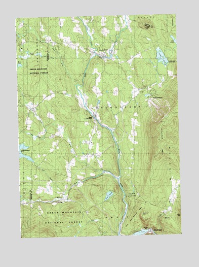
Londonderry, VT USGS Topographic Map
Click on map above to begin viewing in our Map Viewer.

This topographic map contains these locations and features:
Feature Name Type Latitude Longitude GNIS ID View Map
Ball Mountain DamDamN43.1274°W72.7740°1766298View Map
Ball Mountain Dam Picnic GroundsLocaleN43.1629°W72.8051°1461679View Map
Ball Mountain Dam Recreation AreaLocaleN43.1279°W72.7704°1920841View Map
Ball Mountain LakeReservoirN43.1266°W72.7792°1460355View Map
Ball Mountain State ParkParkN43.1309°W72.7734°1461676View Map
Brooks CemeteryCemeteryN43.2156°W72.8140°1460669View Map
Burnt Meadow BrookStreamN43.2281°W72.8404°1460683View Map
Camp DerryLocaleN43.2342°W72.7568°1460696View Map
Champion Fire Company 5BuildingN43.1920°W72.8144°2121209View Map
Cobble HillSummitN43.2442°W72.7726°1460738View Map
Cole PondLakeN43.1479°W72.8060°1460746View Map
Collins CemeteryCemeteryN43.2060°W72.8112°1460748View Map
Cook BrookStreamN43.1584°W72.8051°1460751View Map
Eaton CemeteryCemeteryN43.1781°W72.8504°1920933View Map
Eddy BrookStreamN43.1870°W72.8515°1460839View Map
First Baptist ChurchChurchN43.2279°W72.8084°1920945View Map
Flood BrookStreamN43.2112°W72.8259°1460877View Map
Flood Brook Union SchoolSchoolN43.2369°W72.8483°1920956View Map
Gale Meadows DamDamN43.1684°W72.8629°1766505View Map
Gale Meadows PondReservoirN43.1718°W72.8744°1461752View Map
Glebe MountainSummitN43.1884°W72.7607°1460907View Map
Glebe View CemeteryCemeteryN43.1784°W72.8226°1460908View Map
Hamilton FallsFallsN43.1376°W72.7634°1921003View Map
Hamilton Falls TrailTrailN43.1376°W72.7634°1921004View Map
Hewes CemeteryCemeteryN43.2023°W72.8739°1920282View Map
Landgrove Town CenterPopulated PlaceN43.2367°W72.8648°1920300View Map
Lily PondLakeN43.2351°W72.7512°1461068View Map
LondonderryPopulated PlaceN43.2265°W72.8065°1461093View Map
Londonderry Post OfficePost OfficeN43.2273°W72.8156°1921057View Map
Londonderry Volunteer Rescue SquadBuildingN43.2299°W72.8043°2578128View Map
Lowell LakeReservoirN43.2257°W72.7620°1461102View Map
Lowell Lake CemeteryCemeteryN43.2217°W72.7643°1461103View Map
Lowell Lake DamDamN43.2226°W72.7648°1766437View Map
Magic Mountain Winter Sports AreaLocaleN43.1967°W72.7648°1461680View Map
Majic Mountain Ski CenterLocaleN43.2020°W72.7726°1921060View Map
Middletown CemeteryCemeteryN43.2106°W72.8138°1461152View Map
Mill BrookStreamN43.1501°W72.8395°1461155View Map
Mud PondLakeN43.2230°W72.8726°1461192View Map
Nordio Cross Country Ski AreaLocaleN43.2323°W72.8537°1461685View Map
Osgood - Chubbuck CemeteryCemeteryN43.2222°W72.8057°1921103View Map
Phoenix Fire Company 6BuildingN43.2277°W72.8065°2121210View Map
RawsonvillePopulated PlaceN43.1459°W72.8404°1461313View Map
Rawsonville CemeteryCemeteryN43.1471°W72.8390°1921129View Map
Red BrookStreamN43.1467°W72.8687°1461316View Map
Rest Haven CemeteryCemeteryN43.2083°W72.7849°1461323View Map
Riverside CemeteryCemeteryN43.2302°W72.8149°1461332View Map
Riverside CemeteryCemeteryN43.2301°W72.8320°1921134View Map
Second Congregational ChurchChurchN43.2292°W72.8129°1921167View Map
Shatterack MountainSummitN43.1367°W72.7798°1461389View Map
Sherwood ForestPopulated PlaceN43.2284°W72.8407°1461684View Map
South LondonderryPopulated PlaceN43.1929°W72.8143°1461439View Map
South Londonderry Free LibraryBuildingN43.1911°W72.8128°1921178View Map
South Londonderry Post OfficePost OfficeN43.1922°W72.8140°1921179View Map
South Londonderry Village Historic DistrictParkN43.1929°W72.8148°1921180View Map
Staples CemeteryCemeteryN43.2490°W72.8220°1921189View Map
Stevens CemeteryCemeteryN43.2351°W72.7644°1921191View Map
Stocker AcresPopulated PlaceN43.1279°W72.8740°1920465View Map
Stowell CemeteryCemeteryN43.2319°W72.8236°1921193View Map
ThompsonburgPopulated PlaceN43.2079°W72.7801°1461540View Map
Town of LondonderryCivilN43.2035°W72.8035°1462136View Map
Utley BrookStreamN43.2279°W72.8134°1461560View Map
Viking Cross Country Ski AreaLocaleN43.2242°W72.7951°1461678View Map
Viking Ski Touring CenterLocaleN43.2245°W72.7943°1921231View Map
Viking Winter Sports AreaLocaleN43.2204°W72.8057°1461681View Map
West River Montessori SchoolSchoolN43.2002°W72.8210°2427540View Map
West Windham CemeteryCemeteryN43.1445°W72.7655°1461599View Map
Williams DamDamN43.2265°W72.8074°1766736View Map
Winhall Hollow CemeteryCemeteryN43.1990°W72.8677°1461624View Map
Winhall RiverStreamN43.1570°W72.7970°1461625View Map
Winhall StationLocaleN43.1579°W72.7987°1461626View Map

Note: Coordinates in the location and feature list above are referenced to NAD83 datum.


Copyright (C) 2008-2024 Ryan Niemi / Sunset Dynamics ... All Rights Reserved