TopoQuest Logo
Do you find TopoQuest useful?
Help keep TopoQuest running and adding new maps/features by donating!
Bitcoin:  19c7KJd3qBynnjoSw5npx9KScwjBe4ifkT
Litecoin:  LXs6TkuXGGXo1vDsWCkWVdjQX94eUKd6ui
Home View Maps Find Maps Find Places Resources & Links


Jamestown, Tennessee Topographic Map

USGS Map Title: Jamestown, TN
USGS Map MRC: 36084D8
DRG (GeoTIFF) Download: o36084d8.tif


Neighboring USGS Topographic Map Quads:


  Moodyville, TN  
36085E1
 

  Pall Mall, TN  
36084E8
 

  Sharp Place, TN  
36084E7
 

  Riverton, TN  
36085D1
 

  Jamestown, TN  
36084D8
 

  Stockton, TN  
36084D7
 

  Wilder, TN  
36085C1
 

  Grimsley, TN  
36084C8
 

  Burrville, TN  
36084C7


Map MRC Location:

N37°
W85°
N37°
W84°
H8 H7 H6 H5 H4 H3 H2 H1
G8 G7 G6 G5 G4 G3 G2 G1
F8 F7 F6 F5 F4 F3 F2 F1
E8 E7 E6 E5 E4 E3 E2 E1
D8 D7 D6 D5 D4 D3 D2 D1
C8 C7 C6 C5 C4 C3 C2 C1
B8 B7 B6 B5 B4 B3 B2 B1
A8 A7 A6 A5 A4 A3 A2 A1
N36°
W85°
N36°
W84°

Jamestown, TN USGS 1:24K Topographic Map Preview:
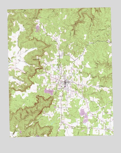
Jamestown, TN USGS Topographic Map
Click on map above to begin viewing in our Map Viewer.

This topographic map contains these locations and features:
Feature Name Type Latitude Longitude GNIS ID View Map
AllardtPopulated PlaceN36.3809°W84.8844°1269300View Map
Allardt Elementary SchoolSchoolN36.3787°W84.8813°1309758View Map
Allardt Fire DepartmentBuildingN36.3809°W84.8820°2654992View Map
Allardt Fire TowerBuildingN36.3827°W84.9052°2654906View Map
Allardt First Baptist ChurchChurchN36.3820°W84.8844°1643383View Map
Allardt Post OfficePost OfficeN36.3819°W84.8850°1650069View Map
Bear BranchStreamN36.4798°W84.9197°1305013View Map
Bear HollowValleyN36.4814°W84.9852°1305020View Map
Buffalo BranchStreamN36.3776°W84.9972°1309757View Map
Buffalo CoveValleyN36.3772°W84.9971°1269395View Map
Campbell HollowValleyN36.4543°W84.9877°1279458View Map
Campbell Hollow BranchStreamN36.4542°W84.9874°1647217View Map
Campbell MountainSummitN36.4531°W84.9652°1279465View Map
Carpenter HollowValleyN36.4563°W84.9875°1279709View Map
Carpenter Hollow BranchStreamN36.4562°W84.9874°1647216View Map
City of AllardtCivilN36.3807°W84.8811°2403081View Map
City of JamestownCivilN36.4319°W84.9340°2404789View Map
Cold SpurRidgeN36.4181°W84.9888°1309750View Map
Commissioner District 1CivilN36.4198°W84.9070°2464230View Map
Commissioner District 2CivilN36.4676°W84.9894°2463918View Map
Crockett CemeteryCemeteryN36.4728°W84.8772°1281643View Map
Crockett CreekStreamN36.4976°W84.9030°1281646View Map
Crooked CreekStreamN36.3909°W84.9116°1281667View Map
Crossroads ChapelChurchN36.4459°W84.9547°1281726View Map
Cumberland GrovePopulated PlaceN36.3845°W84.9249°1647218View Map
David Crockett MineMineN36.4040°W84.9447°1309755View Map
East Jamestown SchoolSchoolN36.4659°W84.8761°1283380View Map
Fentress CountyCivilN36.3805°W84.9325°1639743View Map
Fentress County Ambulance ServiceBuildingN36.4217°W84.9331°2697387View Map
Fentress County Court HouseBuildingN36.4276°W84.9288°1309752View Map
Fentress County CourthouseBuildingN36.4273°W84.9324°1320835View Map
Fentress County Sheriff's DepartmentBuildingN36.4272°W84.9325°2765795View Map
Fentress County Volunteer Fire Department Station 1 JamestownBuildingN36.4262°W84.9319°2654442View Map
Flat SpurRidgeN36.4334°W84.9666°1309749View Map
Gwinn CoveValleyN36.3751°W84.9950°1269614View Map
JamestownPopulated PlaceN36.4276°W84.9319°1289287View Map
Jamestown City CemeteryCemeteryN36.4253°W84.9347°1320841View Map
Jamestown Division (historical)CensusN36.4003°W84.9041°1648688View Map
Jamestown First Baptist ChurchChurchN36.4276°W84.9294°1643381View Map
Jamestown Police DepartmentBuildingN36.4259°W84.9318°2765846View Map
Jamestown Post OfficePost OfficeN36.4284°W84.9316°1650068View Map
Jamestown Regional Medical CenterHospitalN36.4322°W84.9434°1309751View Map
Livingston CemeteryCemeteryN36.4028°W84.9386°1291741View Map
Manson-Wolf River Division (historical)CensusN36.4606°W84.9327°1648689View Map
Miller Spring BranchStreamN36.4806°W84.8758°1293968View Map
Mineral Springs BranchStreamN36.4781°W84.8808°1294040View Map
Old Jamestown ReservoirReservoirN36.4335°W84.8994°1302582View Map
Old Jamestown Reservoir DamDamN36.4317°W84.8983°1302583View Map
Panther BranchStreamN36.4798°W84.9197°1296725View Map
Pine HavenPopulated PlaceN36.4534°W84.9374°1297541View Map
Pine Haven Baptist ChurchChurchN36.4526°W84.9386°1643384View Map
Pine Haven Church of the NazareneChurchN36.4537°W84.9380°1320846View Map
Pine Haven Elementary SchoolSchoolN36.4548°W84.9349°1309748View Map
Rockcastle CoveValleyN36.3775°W84.9969°1309754View Map
Rockcastle CreekStreamN36.3770°W84.9969°1299805View Map
Round Mountain Baptist ChurchChurchN36.4223°W84.8866°1643382View Map
Round Mountain SchoolSchoolN36.4226°W84.8858°1300171View Map
Squirrel FlatPopulated PlaceN36.4906°W84.9694°1314329View Map
Taylor CemeteryCemeteryN36.3876°W84.9366°1272216View Map
The TempleSummitN36.3853°W84.9791°1309756View Map
Waters CemeteryCemeteryN36.3801°W84.9913°1304409View Map
WCLC-AM (Jamestown)TowerN36.4362°W84.9283°1639990View Map
WDEB-AM (Jamestown)TowerN36.4303°W84.9422°1639988View Map
WDEB-FM (Jamestown)TowerN36.4303°W84.9422°1640126View Map
Wispering Winds DamDamN36.4817°W84.9633°1302618View Map
Wispering Winds LakeReservoirN36.4807°W84.9638°1302617View Map
Wolf River Fire TowerBuildingN36.4997°W84.9805°2654684View Map
Wood CemeteryCemeteryN36.4501°W84.9863°1275016View Map
Wright MountainSummitN36.4998°W84.9802°1327430View Map
York Elementary SchoolSchoolN36.4234°W84.9361°1309753View Map
York Institute High SchoolSchoolN36.4442°W84.9380°1652441View Map

Note: Coordinates in the location and feature list above are referenced to NAD83 datum.


Copyright (C) 2008-2024 Ryan Niemi / Sunset Dynamics ... All Rights Reserved