TopoQuest Logo
Do you find TopoQuest useful?
Help keep TopoQuest running and adding new maps/features by donating!
Bitcoin:  19c7KJd3qBynnjoSw5npx9KScwjBe4ifkT
Litecoin:  LXs6TkuXGGXo1vDsWCkWVdjQX94eUKd6ui
Home View Maps Find Maps Find Places Resources & Links


Stockton, Tennessee Topographic Map

USGS Map Title: Stockton, TN
USGS Map MRC: 36084D7
DRG (GeoTIFF) Download: o36084d7.tif


Neighboring USGS Topographic Map Quads:


  Pall Mall, TN  
36084E8
 

  Sharp Place, TN  
36084E7
 

  Barthell SW, TN  
36084E6
 

  Jamestown, TN  
36084D8
 

  Stockton, TN  
36084D7
 

  Honey Creek, TN  
36084D6
 

  Grimsley, TN  
36084C8
 

  Burrville, TN  
36084C7
 

  Rugby, TN  
36084C6


Map MRC Location:

N37°
W85°
N37°
W84°
H8 H7 H6 H5 H4 H3 H2 H1
G8 G7 G6 G5 G4 G3 G2 G1
F8 F7 F6 F5 F4 F3 F2 F1
E8 E7 E6 E5 E4 E3 E2 E1
D8 D7 D6 D5 D4 D3 D2 D1
C8 C7 C6 C5 C4 C3 C2 C1
B8 B7 B6 B5 B4 B3 B2 B1
A8 A7 A6 A5 A4 A3 A2 A1
N36°
W85°
N36°
W84°

Stockton, TN USGS 1:24K Topographic Map Preview:
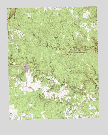
Stockton, TN USGS Topographic Map
Click on map above to begin viewing in our Map Viewer.

This topographic map contains these locations and features:
Feature Name Type Latitude Longitude GNIS ID View Map
Alticrest SchoolSchoolN36.4837°W84.7730°1275641View Map
Armawaithe School (historical)SchoolN36.3756°W84.7799°1320823View Map
Bear BranchStreamN36.3937°W84.7966°1305012View Map
Bole BranchStreamN36.4229°W84.8227°1277898View Map
Boon RidgeRidgeN36.4812°W84.7538°1277975View Map
Booncamp BranchStreamN36.4901°W84.7511°1277976View Map
Briar PointCliffN36.4117°W84.7524°1278313View Map
Campbell BranchStreamN36.3926°W84.7913°1279421View Map
Christian CemeteryCemeteryN36.4245°W84.7580°1280520View Map
Coal Bank HollowValleyN36.4406°W84.8713°1280795View Map
Commissioner District 5CivilN36.4180°W84.7931°2464441View Map
Copley CemeteryCemeteryN36.4437°W84.8549°1281254View Map
Crockett CreekStreamN36.4548°W84.7783°1281645View Map
Crockett RidgeRidgeN36.4690°W84.7974°1281650View Map
East JamestownPopulated PlaceN36.4648°W84.8733°1283379View Map
East Prong Hill CreekStreamN36.4315°W84.8377°1283394View Map
Fentress County Volunteer Fire Department Station 4 ArmathwaiteBuildingN36.3751°W84.7712°2654919View Map
Fentress County Volunteer Fire Department Station 5 East JamestownBuildingN36.4689°W84.8687°2654918View Map
Fletcher BranchStreamN36.4076°W84.7530°1284468View Map
Foster BranchStreamN36.4231°W84.8327°1284690View Map
Fritzsche CreekStreamN36.3978°W84.8491°1284956View Map
Hatfield CreekStreamN36.4534°W84.8061°1287130View Map
Hick CemeteryCemeteryN36.4301°W84.8458°1287532View Map
Jamestown ReservoirReservoirN36.4384°W84.8466°1302584View Map
Jamestown Reservoir DamDamN36.4384°W84.8466°1302585View Map
Lick BranchStreamN36.4226°W84.8130°1291186View Map
Lovely Spring BranchStreamN36.3920°W84.7891°1292154View Map
Lynn BranchStreamN36.3998°W84.8605°1292345View Map
McKinley RidgeRidgeN36.4790°W84.7861°1293369View Map
Mill CreekStreamN36.4065°W84.7719°1293851View Map
Mill Seat CreekStreamN36.4184°W84.7611°1293892View Map
Nichol CreekStreamN36.4373°W84.8672°1295716View Map
Patten BranchStreamN36.3962°W84.8183°1296918View Map
Poplar RidgeRidgeN36.4912°W84.7699°1298216View Map
Potter CemeteryCemeteryN36.3998°W84.7994°1298351View Map
Pumphouse BranchStreamN36.4542°W84.7861°1298672View Map
Rattlesnake BranchStreamN36.4245°W84.8580°1269885View Map
Royal BlueLocaleN36.3926°W84.7502°1307402View Map
Royalston CemeteryCemeteryN36.4737°W84.7616°1300215View Map
Sam BranchStreamN36.4154°W84.7977°1300618View Map
Sharp BranchStreamN36.4948°W84.8677°1301251View Map
Slipshuck RidgeRidgeN36.4248°W84.8352°1270530View Map
Spruce CreekStreamN36.4540°W84.7699°1271156View Map
StocktonPopulated PlaceN36.4054°W84.8227°1314340View Map
Stockton SchoolSchoolN36.4092°W84.8311°1271459View Map
Stone Coal BranchStreamN36.4151°W84.8097°1271486View Map
Tar Kiln RidgeRidgeN36.4237°W84.7891°1272121View Map
Terry CemeteryCemeteryN36.3995°W84.8005°1272338View Map
The NarrowsBendN36.4042°W84.7741°1272418View Map
The WildernessAreaN36.4751°W84.8166°1309759View Map
Thompkin CemeteryCemeteryN36.3978°W84.7610°1272501View Map
West Prong Hill CreekStreamN36.4390°W84.8408°1274220View Map
Yellow CreekStreamN36.4323°W84.8483°1304701View Map

Note: Coordinates in the location and feature list above are referenced to NAD83 datum.


Copyright (C) 2008-2024 Ryan Niemi / Sunset Dynamics ... All Rights Reserved