TopoQuest Logo
Do you find TopoQuest useful?
Help keep TopoQuest running and adding new maps/features by donating!
Bitcoin:  19c7KJd3qBynnjoSw5npx9KScwjBe4ifkT
Litecoin:  LXs6TkuXGGXo1vDsWCkWVdjQX94eUKd6ui
Home View Maps Find Maps Find Places Resources & Links


Jamestown, Arkansas Topographic Map

USGS Map Title: Jamestown, AR
USGS Map MRC: 35091F6
DRG (GeoTIFF) Download: o35091f6.tif


Neighboring USGS Topographic Map Quads:


  Bethesda, AR  
35091G7
 

  Batesville, AR  
35091G6
 

  Sulphur Rock, AR  
35091G5
 

  Concord, AR  
35091F7
 

  Jamestown, AR  
35091F6
 

  Salado, AR  
35091F5
 

  Floral, AR  
35091E7
 

  Pleasant Plains, AR  
35091E6
 

  Huff, AR  
35091E5


Map MRC Location:

N36°
W92°
N36°
W91°
H8 H7 H6 H5 H4 H3 H2 H1
G8 G7 G6 G5 G4 G3 G2 G1
F8 F7 F6 F5 F4 F3 F2 F1
E8 E7 E6 E5 E4 E3 E2 E1
D8 D7 D6 D5 D4 D3 D2 D1
C8 C7 C6 C5 C4 C3 C2 C1
B8 B7 B6 B5 B4 B3 B2 B1
A8 A7 A6 A5 A4 A3 A2 A1
N35°
W92°
N35°
W91°

Jamestown, AR USGS 1:24K Topographic Map Preview:
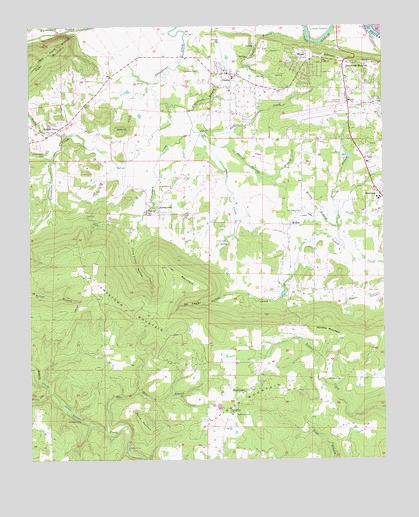
Jamestown, AR USGS Topographic Map
Click on map above to begin viewing in our Map Viewer.

This topographic map contains these locations and features:
Feature Name Type Latitude Longitude GNIS ID View Map
Alderbrook BranchStreamN35.7259°W91.6943°45809View Map
Alderbrook CemeteryCemeteryN35.7373°W91.6907°45810View Map
Allen ChapelChurchN35.7279°W91.6285°45832View Map
Batesville Regional AirportAirportN35.7277°W91.6415°83634View Map
Blue Hole BranchStreamN35.6331°W91.7226°46750View Map
BryantPopulated PlaceN35.7417°W91.6521°57458View Map
Buffalo CreekStreamN35.7209°W91.6929°47155View Map
City of SouthsideCivilN35.7194°W91.6416°2771128View Map
Clearview EstatesPopulated PlaceN35.7373°W91.6501°67991View Map
Cobb MountainSummitN35.6759°W91.6971°57561View Map
Dennison HeightsPopulated PlaceN35.7376°W91.6393°57642View Map
DeshaPopulated PlaceN35.7362°W91.6799°76786View Map
Desha Elementary SchoolSchoolN35.7354°W91.6782°68001View Map
Desha Fire Department Central StationBuildingN35.7322°W91.6672°2116360View Map
Desha Post OfficePost OfficeN35.7376°W91.6801°84413View Map
Desha Volunteer Fire DepartmentBuildingN35.7369°W91.6803°2116361View Map
Desha Volunteer Fire Department Locust Grove StationBuildingN35.7201°W91.7388°2116359View Map
Double BranchStreamN35.6856°W91.6390°48575View Map
Ed Taylor HollowValleyN35.6734°W91.6757°48814View Map
Grady CampLocaleN35.6284°W91.7157°49534View Map
Grassy CreekStreamN35.6440°W91.7435°49567View Map
HutchinsonPopulated PlaceN35.6448°W91.6743°50470View Map
Hutchinson ChurchChurchN35.6379°W91.6793°50472View Map
Hutchinson MountainSummitN35.6434°W91.6751°57962View Map
Inman CemeteryCemeteryN35.6878°W91.6810°50512View Map
Inman CreekStreamN35.7195°W91.6896°50513View Map
JamestownPopulated PlaceN35.6967°W91.7046°57980View Map
Jamestown ChurchChurchN35.7034°W91.7004°50586View Map
Jamestown CreekStreamN35.7273°W91.7015°50587View Map
Jamestown MountainSummitN35.6781°W91.7304°50588View Map
KAAB-AM (Batesville)TowerN35.7445°W91.6393°85051View Map
Kyler CemeteryCemeteryN35.6742°W91.6282°50921View Map
Locust GrovePopulated PlaceN35.7209°W91.7385°51373View Map
Locust Grove CemeteryCemeteryN35.7128°W91.7443°51375View Map
Locust Grove Post OfficePost OfficeN35.7198°W91.6904°84415View Map
McHuePopulated PlaceN35.6929°W91.6582°58150View Map
Morris Stuart LakeReservoirN35.6501°W91.6835°79884View Map
Morris Stuart Lake DamDamN35.6501°W91.6835°79883View Map
Muddy BranchStreamN35.6915°W91.6415°52529View Map
Oak Grove ChurchChurchN35.6481°W91.6454°52913View Map
Oak Valley ChurchChurchN35.6967°W91.6551°52945View Map
Old Clem Place (historical)LocaleN35.6445°W91.7432°68038View Map
Palestine CemeteryCemeteryN35.6381°W91.6782°53132View Map
Piney Log CreekStreamN35.6437°W91.7435°53491View Map
Ramsey HillSummitN35.7390°W91.6296°58458View Map
Ramsey SloughLakeN35.7490°W91.6519°54866View Map
RiverviewPopulated PlaceN35.7420°W91.6560°68046View Map
Rocky CreekStreamN35.7184°W91.7365°54134View Map
Round MountainSummitN35.6348°W91.7088°58538View Map
Rutledge CampLocaleN35.6367°W91.7326°54296View Map
Sheriff Springs BranchStreamN35.7184°W91.6890°54765View Map
Slate HillSummitN35.7201°W91.7168°58633View Map
Southside Fire Station 1BuildingN35.7155°W91.6343°2117153View Map
Southside Fire Station 3BuildingN35.6465°W91.6737°2117155View Map
Southside High SchoolSchoolN35.7004°W91.6261°68055View Map
Southside Middle SchoolSchoolN35.7016°W91.6312°2039087View Map
Strother MountainSummitN35.6626°W91.6454°58700View Map
Taylor BranchStreamN35.7462°W91.6518°55458View Map
Tivis Flynn HollowValleyN35.6940°W91.7115°55583View Map
Township of GreenbrierCivilN35.7202°W91.7418°68766View Map
Township of McHueCivilN35.7077°W91.6505°68772View Map
Township of ReliefCivilN35.6503°W91.7230°68777View Map

Note: Coordinates in the location and feature list above are referenced to NAD83 datum.


Copyright (C) 2008-2025 Ryan Niemi / Sunset Dynamics ... All Rights Reserved