TopoQuest Logo
Do you find TopoQuest useful?
Help keep TopoQuest running and adding new maps/features by donating!
Bitcoin:  19c7KJd3qBynnjoSw5npx9KScwjBe4ifkT
Litecoin:  LXs6TkuXGGXo1vDsWCkWVdjQX94eUKd6ui
Home View Maps Find Maps Find Places Resources & Links


Sulphur Rock, Arkansas Topographic Map

USGS Map Title: Sulphur Rock, AR
USGS Map MRC: 35091G5
DRG (GeoTIFF) Download: o35091g5.tif


Neighboring USGS Topographic Map Quads:


  Sandtown, AR  
35091H6
 

  Cave City, AR  
35091H5
 

  Grange, AR  
35091H4
 

  Batesville, AR  
35091G6
 

  Sulphur Rock, AR  
35091G5
 

  Charlotte, AR  
35091G4
 

  Jamestown, AR  
35091F6
 

  Salado, AR  
35091F5
 

  Newark, AR  
35091F4


Map MRC Location:

N36°
W92°
N36°
W91°
H8 H7 H6 H5 H4 H3 H2 H1
G8 G7 G6 G5 G4 G3 G2 G1
F8 F7 F6 F5 F4 F3 F2 F1
E8 E7 E6 E5 E4 E3 E2 E1
D8 D7 D6 D5 D4 D3 D2 D1
C8 C7 C6 C5 C4 C3 C2 C1
B8 B7 B6 B5 B4 B3 B2 B1
A8 A7 A6 A5 A4 A3 A2 A1
N35°
W92°
N35°
W91°

Sulphur Rock, AR USGS 1:24K Topographic Map Preview:
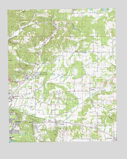
Sulphur Rock, AR USGS Topographic Map
Click on map above to begin viewing in our Map Viewer.

This topographic map contains these locations and features:
Feature Name Type Latitude Longitude GNIS ID View Map
Adler HillSummitN35.8584°W91.6232°57249View Map
Balch AdditionPopulated PlaceN35.7704°W91.5921°67974View Map
Bales MineMineN35.8559°W91.5935°81395View Map
Batesville High SchoolSchoolN35.7547°W91.6240°2039089View Map
Batesville Junior High SchoolSchoolN35.7554°W91.6218°56874View Map
Batesville Senior High SchoolSchoolN35.7542°W91.6237°56873View Map
Bethel CemeteryCemeteryN35.8339°W91.5215°46433View Map
Blue CreekStreamN35.7751°W91.5993°76380View Map
Brewer HillSummitN35.8226°W91.6074°57432View Map
Brewer SchoolSchoolN35.8417°W91.6118°46928View Map
Bryant Woodland HeightsPopulated PlaceN35.7565°W91.6237°67985View Map
Cave Creek ChurchChurchN35.8481°W91.6232°47542View Map
Cave Creek Church of GodChurchN35.8629°W91.5924°56832View Map
Center Hall School (historical)SchoolN35.8326°W91.5307°56805View Map
Christian Golden Rule ChurchChurchN35.7901°W91.5487°56879View Map
City of BatesvilleCivilN35.7687°W91.6226°2403819View Map
College Heights AdditionPopulated PlaceN35.7709°W91.6232°67992View Map
Cooper Cane CreekStreamN35.7692°W91.5143°48007View Map
Corinth Church of GodChurchN35.8742°W91.5479°56878View Map
Davidson HollowValleyN35.7787°W91.5079°48371View Map
Davis HillSummitN35.8609°W91.6076°57627View Map
Deer Lick WoodsWoodsN35.7715°W91.5290°48459View Map
Dunegan ProspectMineN35.8579°W91.5946°81423View Map
Eagle Mountain Magnet Elementary SchoolSchoolN35.7588°W91.6098°2039086View Map
East Batesville Freewill Baptist ChurchChurchN35.7690°W91.6087°68002View Map
Eastwood AdditionPopulated PlaceN35.7640°W91.6210°68003View Map
Ford SpringSpringN35.8144°W91.5741°49158View Map
Full Gospel Fellowship ChurchChurchN35.7717°W91.6199°68012View Map
G A Wilson MineMineN35.8617°W91.6099°81433View Map
GainsboroPopulated PlaceN35.7967°W91.5315°57026View Map
Gateway Vocational-Technical SchoolSchoolN35.7940°W91.6168°56875View Map
Goforth Lake DamDamN35.8567°W91.5451°80951View Map
Goforth MountainSummitN35.8723°W91.6126°57830View Map
Goforth ReservoirReservoirN35.8569°W91.5466°80952View Map
Gravel CreekStreamN35.8045°W91.5826°49584View Map
Gum HollowValleyN35.7737°W91.5107°49716View Map
Haddock CemeteryCemeteryN35.8076°W91.5135°49753View Map
Havison CemeteryCemeteryN35.7806°W91.5146°56872View Map
Henley MineMineN35.8598°W91.6085°81443View Map
Hope Lutheran ChurchChurchN35.7926°W91.6210°56876View Map
Hunt Hollow MineMineN35.8742°W91.6213°81446View Map
J A Reves MineMineN35.8495°W91.6071°81447View Map
Lake Kimberly DamDamN35.8734°W91.5101°80953View Map
Lee Britten LakeReservoirN35.8324°W91.5344°79876View Map
Lee Britten Lake DamDamN35.8334°W91.5335°79875View Map
Lees Chapel CemeteryCemeteryN35.7909°W91.5665°56814View Map
Liberty CemeteryCemeteryN35.8292°W91.5076°56882View Map
Liberty ChurchChurchN35.8298°W91.5071°51106View Map
Lyon CollegeSchoolN35.7776°W91.6243°56871View Map
M W Reves ProspectMineN35.8576°W91.6129°81462View Map
Matheny MineMineN35.8645°W91.5971°81465View Map
Meacham Cave HillSummitN35.8154°W91.6129°58156View Map
Miller CreekStreamN35.8551°W91.5687°52062View Map
Modlin HollowValleyN35.8473°W91.6240°52126View Map
Montgomery SpringSpringN35.7501°W91.5862°52142View Map
MoorefieldPopulated PlaceN35.7684°W91.5704°52170View Map
Moorefield CreekStreamN35.7734°W91.5807°52171View Map
Mount Zion CemeteryCemeteryN35.8009°W91.5987°56877View Map
Moyer MineMineN35.8551°W91.6037°81474View Map
New Hope School (historical)SchoolN35.7884°W91.5137°56824View Map
Northside Fire DepartmentBuildingN35.7920°W91.6112°56881View Map
Northside Fire StationBuildingN35.8162°W91.5977°2116880View Map
O'Flinn ProspectMineN35.8451°W91.6190°81476View Map
Ozark MineMineN35.8734°W91.5982°81477View Map
PfeifferPopulated PlaceN35.8240°W91.5879°58353View Map
Pfeiffer CreekStreamN35.7823°W91.6190°77984View Map
Pfeiffer JunctionLocaleN35.7812°W91.6218°77985View Map
Pfeiffer SchoolSchoolN35.8234°W91.5796°53316View Map
Pleasant Valley Missionary Baptist ChurchChurchN35.7920°W91.5971°78858View Map
Quail ValleyPopulated PlaceN35.7565°W91.5904°68043View Map
R L Knies LakeReservoirN35.8717°W91.5185°79886View Map
R L Knies Lake DamDamN35.8717°W91.5185°79885View Map
Reed SchoolSchoolN35.7987°W91.5979°53971View Map
Rehobeth Baptist Church (historical)ChurchN35.7812°W91.5715°68045View Map
Reobeth CemeteryCemeteryN35.7809°W91.5718°56829View Map
Rogers AdditionPopulated PlaceN35.7773°W91.6182°68047View Map
Saint Clair SpringSpringN35.8484°W91.5751°54317View Map
Sanders CemeteryCemeteryN35.7562°W91.5404°54552View Map
Schlieper MineMineN35.8729°W91.5929°81497View Map
Schlieper SpringSpringN35.8729°W91.5924°54618View Map
Searcy MineMineN35.8670°W91.6124°81498View Map
Searcy SpringSpringN35.8648°W91.6110°81499View Map
SharpPopulated PlaceN35.8137°W91.5357°81947View Map
Sharp United Methodist ChurchChurchN35.8270°W91.5207°78335View Map
Silberstein ProspectMineN35.8559°W91.6054°81505View Map
Stark CemeteryCemeteryN35.7828°W91.5996°56870View Map
Sulphur RockPopulated PlaceN35.7512°W91.5007°58709View Map
The Alter Call ChurchChurchN35.7678°W91.5916°2680016View Map
Town of MoorefieldCivilN35.7672°W91.5708°2406186View Map
Town of Sulphur RockCivilN35.7516°W91.5001°2406680View Map
Township of GainsboroCivilN35.8250°W91.5141°68765View Map
Township of MoorefieldCivilN35.7742°W91.5691°68775View Map
Waits HillSummitN35.7592°W91.5287°58809View Map
Walbert MineMineN35.8431°W91.6160°81525View Map
Watson CreekStreamN35.7848°W91.5451°56111View Map
Weaver's CemeteryCemeteryN35.8609°W91.5712°56880View Map
Weavers CemeteryCemeteryN35.8609°W91.5712°56837View Map
Weavers ChapelChurchN35.8606°W91.5712°56833View Map
Wolford AdditionPopulated PlaceN35.7679°W91.6162°68064View Map
Wood CemeteryCemeteryN35.8006°W91.5004°56835View Map
Woodland Nursing HomeBuildingN35.7723°W91.6190°68065View Map

Note: Coordinates in the location and feature list above are referenced to NAD83 datum.


Copyright (C) 2008-2024 Ryan Niemi / Sunset Dynamics ... All Rights Reserved