TopoQuest Logo
Do you find TopoQuest useful?
Help keep TopoQuest running and adding new maps/features by donating!
Bitcoin:  19c7KJd3qBynnjoSw5npx9KScwjBe4ifkT
Litecoin:  LXs6TkuXGGXo1vDsWCkWVdjQX94eUKd6ui
Home View Maps Find Maps Find Places Resources & Links


Jamesville, North Carolina Topographic Map

USGS Map Title: Jamesville, NC
USGS Map MRC: 35076G8
DRG (GeoTIFF) Download: o35076g8.tif


Neighboring USGS Topographic Map Quads:


  Quitsna, NC  
35077H1
 

  Windsor South, NC  
35076H8
 

  Woodard, NC  
35076H7
 

  Williamston, NC  
35077G1
 

  Jamesville, NC  
35076G8
 

  Plymouth West, NC  
35076G7
 

  Old Ford, NC  
35077F1
 

  Farmlife, NC  
35076F8
 

  Hoke, NC  
35076F7


Map MRC Location:

N36°
W77°
N36°
W76°
H8 H7 H6 H5 H4 H3 H2 H1
G8 G7 G6 G5 G4 G3 G2 G1
F8 F7 F6 F5 F4 F3 F2 F1
E8 E7 E6 E5 E4 E3 E2 E1
D8 D7 D6 D5 D4 D3 D2 D1
C8 C7 C6 C5 C4 C3 C2 C1
B8 B7 B6 B5 B4 B3 B2 B1
A8 A7 A6 A5 A4 A3 A2 A1
N35°
W77°
N35°
W76°

Jamesville, NC USGS 1:24K Topographic Map Preview:
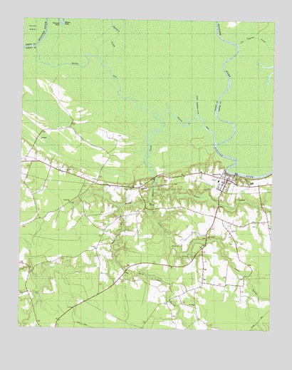
Jamesville, NC USGS Topographic Map
Click on map above to begin viewing in our Map Viewer.

This topographic map contains these locations and features:
Feature Name Type Latitude Longitude GNIS ID View Map
Cedar Branch ChurchChurchN35.7877°W76.9063°982797View Map
Cooper SwampStreamN35.8074°W76.9325°983512View Map
Cut Cypress CreekGutN35.8660°W76.8786°983864View Map
Deep Run SwampStreamN35.8013°W76.9352°984099View Map
Devils GutGutN35.8432°W76.9469°1025283View Map
Fairview ChurchChurchN35.7824°W76.9616°984917View Map
Friends ChurchChurchN35.7902°W76.8944°985424View Map
Gardner CreekStreamN35.8360°W76.9333°985562View Map
Goddard Hill ChurchChurchN35.8010°W76.9747°985755View Map
JamesvillePopulated PlaceN35.8113°W76.8966°1025426View Map
Jamesville Baptist ChurchChurchN35.8087°W76.8992°2506170View Map
Jamesville ChurchChurchN35.7602°W76.9119°987521View Map
Jamesville Community Emergency Medical Services and RescueBuildingN35.8099°W76.8965°2720711View Map
Jamesville Community Volunteer Fire DepartmentBuildingN35.8100°W76.8970°2638487View Map
Jamesville Post OfficePost OfficeN35.8114°W76.9010°2505376View Map
Jamesville Union SchoolSchoolN35.8104°W76.9011°1025976View Map
Jamesville United Methodist ChurchChurchN35.8099°W76.8943°2506171View Map
Kaders EddyBendN35.8727°W76.9800°1025445View Map
Lanier SwampStreamN35.8013°W76.9352°988142View Map
Lower Deadwater CreekStreamN35.8368°W76.9125°989092View Map
Saint James ChurchChurchN35.8132°W76.9772°993914View Map
Siloam ChurchChurchN35.8068°W76.9458°994806View Map
Spellers CreekGutN35.8710°W76.9536°1025723View Map
Tar LandingLocaleN35.8004°W76.9355°1025738View Map
Town of JamesvilleCivilN35.8120°W76.9002°2405905View Map
Township of WilliamsCivilN35.8310°W76.9708°1026928View Map

Note: Coordinates in the location and feature list above are referenced to NAD83 datum.


Copyright (C) 2008-2025 Ryan Niemi / Sunset Dynamics ... All Rights Reserved