TopoQuest Logo
Do you find TopoQuest useful?
Help keep TopoQuest running and adding new maps/features by donating!
Bitcoin:  19c7KJd3qBynnjoSw5npx9KScwjBe4ifkT
Litecoin:  LXs6TkuXGGXo1vDsWCkWVdjQX94eUKd6ui
Home View Maps Find Maps Find Places Resources & Links


Windsor South, North Carolina Topographic Map

USGS Map Title: Windsor South, NC
USGS Map MRC: 35076H8
DRG (GeoTIFF) Download: o35076h8.tif


Neighboring USGS Topographic Map Quads:


  Republican, NC  
36077A1
 

  Windsor North, NC  
36076A8
 

  Merry Hill, NC  
36076A7
 

  Quitsna, NC  
35077H1
 

  Windsor South, NC  
35076H8
 

  Woodard, NC  
35076H7
 

  Williamston, NC  
35077G1
 

  Jamesville, NC  
35076G8
 

  Plymouth West, NC  
35076G7


Map MRC Location:

N36°
W77°
N36°
W76°
H8 H7 H6 H5 H4 H3 H2 H1
G8 G7 G6 G5 G4 G3 G2 G1
F8 F7 F6 F5 F4 F3 F2 F1
E8 E7 E6 E5 E4 E3 E2 E1
D8 D7 D6 D5 D4 D3 D2 D1
C8 C7 C6 C5 C4 C3 C2 C1
B8 B7 B6 B5 B4 B3 B2 B1
A8 A7 A6 A5 A4 A3 A2 A1
N35°
W77°
N35°
W76°

Windsor South, NC USGS 1:24K Topographic Map Preview:
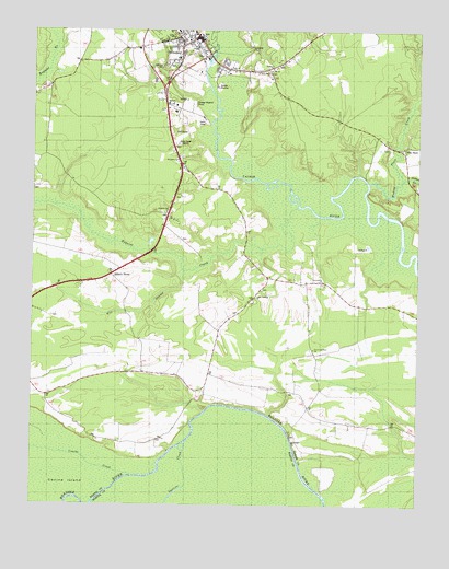
Windsor South, NC USGS Topographic Map
Click on map above to begin viewing in our Map Viewer.

This topographic map contains these locations and features:
Feature Name Type Latitude Longitude GNIS ID View Map
Bertie Ambulance ServiceBuildingN35.9915°W76.9397°2720670View Map
Bertie Correctional InstitutionBuildingN35.9691°W76.9085°2769830View Map
Bertie County Rescue SquadBuildingN35.9990°W76.9457°2720656View Map
Bertie County Sheriff's OfficeBuildingN35.9969°W76.9467°2130847View Map
Bertie Martin Regional JailBuildingN35.9759°W76.9435°2131028View Map
Brian Center Health and Rehabilitation of WindsorBuildingN35.9903°W76.9302°2505843View Map
Cedar LandingLocaleN35.9024°W76.9400°1006444View Map
Cedar Landing ChurchChurchN35.9299°W76.9272°982884View Map
Coastal Medical Transport - WindsorBuildingN35.9957°W76.9523°2720550View Map
Community ChurchChurchN35.9338°W76.9055°983415View Map
Conine CreekStreamN35.8827°W76.9669°983452View Map
Ellis StorePopulated PlaceN35.9693°W76.8794°1025310View Map
Faith ChurchChurchN35.9904°W76.9361°984954View Map
Fork LandingLocaleN35.9599°W76.9308°1006445View Map
Harrells QuarterLocaleN35.8793°W76.9052°1006437View Map
Hillcrest CemeteryCemeteryN35.9910°W76.9566°986806View Map
Howard LandingLocaleN35.9615°W76.8919°1006436View Map
Jordans LandingLocaleN35.8893°W76.9552°1006433View Map
Mill SwampStreamN35.9365°W76.9505°1025543View Map
Millers StorePopulated PlaceN35.9357°W76.9738°1025546View Map
Mooring LandingLocaleN35.8927°W76.9150°1006430View Map
Peace and Glory ChurchChurchN35.9160°W76.9086°991972View Map
Pleasant Oak ChurchChurchN35.9521°W76.9563°992555View Map
Robins LandingLocaleN35.9613°W76.9358°1006425View Map
Roquist CreekStreamN35.9535°W76.9141°1025656View Map
Saint James ChurchChurchN35.9663°W76.9530°993916View Map
Sandy Point ChurchChurchN35.9896°W76.9230°994308View Map
Sutton CreekStreamN35.9607°W76.8800°995730View Map
Three Rivers Health and Rehabilitation CenterBuildingN35.9867°W76.9290°2506022View Map
Thunderbolt LandingLocaleN35.9507°W76.8802°1006421View Map
Town of WindsorCivilN35.9930°W76.9399°2406899View Map
Township of WindsorCivilN35.9713°W76.9223°1026419View Map
Vidant Bertie HospitalHospitalN35.9887°W76.9282°2094858View Map
Wading Place CreekStreamN35.9602°W76.8911°1025770View Map
WBTE-AM (Windsor)TowerN35.9668°W76.9480°1018523View Map
WindsorPopulated PlaceN35.9985°W76.9461°1023279View Map
Windsor ChurchChurchN35.9902°W76.9222°997477View Map
Windsor Police DepartmentBuildingN35.9979°W76.9458°2130925View Map
Windsor Post OfficePost OfficeN35.9991°W76.9474°2774147View Map

Note: Coordinates in the location and feature list above are referenced to NAD83 datum.


Copyright (C) 2008-2025 Ryan Niemi / Sunset Dynamics ... All Rights Reserved