TopoQuest Logo
Do you find TopoQuest useful?
Help keep TopoQuest running and adding new maps/features by donating!
Bitcoin:  19c7KJd3qBynnjoSw5npx9KScwjBe4ifkT
Litecoin:  LXs6TkuXGGXo1vDsWCkWVdjQX94eUKd6ui
Home View Maps Find Maps Find Places Resources & Links


Quitsna, North Carolina Topographic Map

USGS Map Title: Quitsna, NC
USGS Map MRC: 35077H1
DRG (GeoTIFF) Download: o35077h1.tif


Neighboring USGS Topographic Map Quads:


  Lewiston Woodville, NC  
36077A2
 

  Republican, NC  
36077A1
 

  Windsor North, NC  
36076A8
 

  Hamilton, NC  
35077H2
 

  Quitsna, NC  
35077H1
 

  Windsor South, NC  
35076H8
 

  Robersonville East, NC  
35077G2
 

  Williamston, NC  
35077G1
 

  Jamesville, NC  
35076G8


Map MRC Location:

N36°
W78°
N36°
W77°
H8 H7 H6 H5 H4 H3 H2 H1
G8 G7 G6 G5 G4 G3 G2 G1
F8 F7 F6 F5 F4 F3 F2 F1
E8 E7 E6 E5 E4 E3 E2 E1
D8 D7 D6 D5 D4 D3 D2 D1
C8 C7 C6 C5 C4 C3 C2 C1
B8 B7 B6 B5 B4 B3 B2 B1
A8 A7 A6 A5 A4 A3 A2 A1
N35°
W78°
N35°
W77°

Quitsna, NC USGS 1:24K Topographic Map Preview:
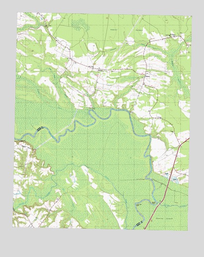
Quitsna, NC USGS Topographic Map
Click on map above to begin viewing in our Map Viewer.

This topographic map contains these locations and features:
Feature Name Type Latitude Longitude GNIS ID View Map
Beacon Light ChurchChurchN35.9879°W77.0144°1003853View Map
Blue Jay Volunteer Fire CompanyBuildingN35.9997°W77.1085°2638637View Map
Choowatic CreekStreamN35.9682°W77.0136°1023905View Map
Conine BendBendN35.8907°W77.0233°1023919View Map
Conine IslandIslandN35.8782°W77.0058°1019755View Map
Coniott CreekStreamN35.9443°W77.0725°983453View Map
Coniott LandingLocaleN35.9454°W77.0705°1023920View Map
Conoho CreekStreamN35.8757°W77.0444°1023921View Map
Frog Level SwampSwampN35.9429°W77.0797°1023986View Map
Frying Pan BendBendN35.8904°W77.0372°1023987View Map
GrabtownPopulated PlaceN35.9571°W77.0330°1023993View Map
Indian Woods ChurchChurchN35.9682°W77.0697°1003854View Map
Macedonia ChurchChurchN35.9885°W77.0122°1003852View Map
Mill BranchStreamN35.9004°W77.0936°1024149View Map
Old Mill LandingLocaleN35.9324°W77.0263°1021735View Map
Poplar PointCapeN35.9235°W77.1205°1024490View Map
Poplar Point LandingLocaleN35.9252°W77.1205°1024237View Map
QuitsnaPopulated PlaceN35.9699°W77.0672°1022128View Map
Quitsna LandingLocaleN35.9432°W77.0411°1022129View Map
Saint Francis ChurchChurchN35.9404°W77.0202°1003855View Map
Siloam ChurchChurchN35.9324°W77.0113°1003856View Map
Spellers Ferry LandingLocaleN35.9149°W77.0250°1022731View Map
Township of Indian WoodsCivilN35.9758°W77.0590°1026413View Map

Note: Coordinates in the location and feature list above are referenced to NAD83 datum.


Copyright (C) 2008-2025 Ryan Niemi / Sunset Dynamics ... All Rights Reserved