TopoQuest Logo
Do you find TopoQuest useful?
Help keep TopoQuest running and adding new maps/features by donating!
Bitcoin:  19c7KJd3qBynnjoSw5npx9KScwjBe4ifkT
Litecoin:  LXs6TkuXGGXo1vDsWCkWVdjQX94eUKd6ui
Home View Maps Find Maps Find Places Resources & Links


Baldwyn, Mississippi Topographic Map

USGS Map Title: Baldwyn, MS
USGS Map MRC: 34088E6
DRG (GeoTIFF) Download: o34088e6.tif


Neighboring USGS Topographic Map Quads:


  Dumas, MS  
34088F7
 

  Jumpertown, MS  
34088F6
 

  Booneville, MS  
34088F5
 

  Pleasant Ridge, MS  
34088E7
 

  Baldwyn, MS  
34088E6
 

  Wheeler, MS  
34088E5
 

  Ellistown, MS  
34088D7
 

  Guntown, MS  
34088D6
 

  Ratliff, MS  
34088D5


Map MRC Location:

N35°
W89°
N35°
W88°
H8 H7 H6 H5 H4 H3 H2 H1
G8 G7 G6 G5 G4 G3 G2 G1
F8 F7 F6 F5 F4 F3 F2 F1
E8 E7 E6 E5 E4 E3 E2 E1
D8 D7 D6 D5 D4 D3 D2 D1
C8 C7 C6 C5 C4 C3 C2 C1
B8 B7 B6 B5 B4 B3 B2 B1
A8 A7 A6 A5 A4 A3 A2 A1
N34°
W89°
N34°
W88°

Baldwyn, MS USGS 1:24K Topographic Map Preview:
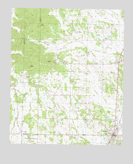
Baldwyn, MS USGS Topographic Map
Click on map above to begin viewing in our Map Viewer.

This topographic map contains these locations and features:
Feature Name Type Latitude Longitude GNIS ID View Map
Asbury CemeteryCemeteryN34.5595°W88.6473°706124View Map
Asbury ChurchChurchN34.5598°W88.6478°666387View Map
BaldwynPopulated PlaceN34.5095°W88.6353°666483View Map
Baldwyn Church of ChristChurchN34.5107°W88.6348°706125View Map
Baldwyn Elementary SchoolSchoolN34.5143°W88.6328°706126View Map
Baldwyn Fire DepartmentBuildingN34.5087°W88.6335°2665928View Map
Baldwyn High SchoolSchoolN34.5154°W88.6312°706127View Map
Baldwyn HospitalHospitalN34.5009°W88.6428°708958View Map
Baldwyn Middle SchoolSchoolN34.5043°W88.6253°708959View Map
Baldwyn Police DepartmentBuildingN34.5235°W88.6329°2754210View Map
Baldwyn Post OfficePost OfficeN34.5095°W88.6350°2768596View Map
Baldwyn Presbyterian ChurchChurchN34.5087°W88.6345°686935View Map
BethanyPopulated PlaceN34.5054°W88.7292°666858View Map
Bethany CemeteryCemeteryN34.5051°W88.7281°708963View Map
Bethany Presbyterian ChurchChurchN34.5390°W88.7287°708964View Map
Bethel ChurchChurchN34.5004°W88.7228°666957View Map
Booneville/Baldwyn AirportAirportN34.5935°W88.6486°680433View Map
Brices Cross Roads National Battlefield SiteParkN34.5061°W88.7289°667556View Map
Brices Crossroads National Battlefield CemeteryCemeteryN34.5070°W88.7284°708969View Map
Carrollville (historical)LocaleN34.5270°W88.6584°706146View Map
Carrollville CemeteryCemeteryN34.5236°W88.6564°709858View Map
City of BaldwynCivilN34.5071°W88.6416°2403150View Map
First Baptist ChurchChurchN34.5029°W88.6387°686991View Map
First United Methodist ChurchChurchN34.5104°W88.6359°683638View Map
FrankstownPopulated PlaceN34.5765°W88.6298°670168View Map
GeevillePopulated PlaceN34.5762°W88.6909°670350View Map
Geeville MountainSummitN34.5762°W88.7045°670351View Map
Geeville School (historical)SchoolN34.5734°W88.7014°706164View Map
Ingram CemeteryCemeteryN34.5231°W88.6923°706168View Map
Ingram ChurchChurchN34.5229°W88.6923°671710View Map
Ingram Volunteer Fire DepartmentBuildingN34.5232°W88.6896°2665969View Map
Kitchen MountainSummitN34.6093°W88.7192°672195View Map
LebanonPopulated PlaceN34.5565°W88.7334°706173View Map
Lebanon CemeteryCemeteryN34.5604°W88.7312°706174View Map
Lebanon ChurchChurchN34.5615°W88.7314°672358View Map
Lebanon MountainSummitN34.5715°W88.7289°672360View Map
Little Wolf CreekStreamN34.6093°W88.6306°672711View Map
Maiden School (historical)SchoolN34.5376°W88.6739°683652View Map
Mount Nebo Christian Methodist Episcopal ChurchChurchN34.5004°W88.6298°690964View Map
Mount Olive CemeteryCemeteryN34.5737°W88.7003°706187View Map
Mount Olive ChurchChurchN34.5748°W88.7003°674165View Map
Mount Olive ChurchChurchN34.5829°W88.6662°674166View Map
Oak Hill CemeteryCemeteryN34.6198°W88.6750°706195View Map
Oak Hill ChurchChurchN34.6207°W88.6751°675081View Map
Oak Hill School (historical)SchoolN34.6237°W88.6823°683656View Map
Old Calvary CemeteryCemeteryN34.5241°W88.6569°2701840View Map
Osborne Creek ChurchChurchN34.6240°W88.6251°675318View Map
Osborne School (historical)SchoolN34.6229°W88.6253°683657View Map
Prentiss County Memorial GardensCemeteryN34.5662°W88.6325°691604View Map
Prentiss School (historical)SchoolN34.5395°W88.7028°683666View Map
Ruben ChapelChurchN34.5965°W88.6526°676941View Map
Rubens Chapel CemeteryCemeteryN34.5965°W88.6531°706206View Map
Sheppard CemeteryCemeteryN34.5581°W88.6820°677649View Map
Stevenson School (historical)SchoolN34.5301°W88.7092°683675View Map
Tabernacle ChurchChurchN34.5418°W88.6317°678535View Map
Tabernacle School (historical)SchoolN34.5520°W88.6453°683677View Map
Tippah HillsSummitN34.6109°W88.7303°678772View Map
Yanco (historical)LocaleN34.6154°W88.7264°683557View Map

Note: Coordinates in the location and feature list above are referenced to NAD83 datum.


Copyright (C) 2008-2024 Ryan Niemi / Sunset Dynamics ... All Rights Reserved