TopoQuest Logo
Do you find TopoQuest useful?
Help keep TopoQuest running and adding new maps/features by donating!
Bitcoin:  19c7KJd3qBynnjoSw5npx9KScwjBe4ifkT
Litecoin:  LXs6TkuXGGXo1vDsWCkWVdjQX94eUKd6ui
Home View Maps Find Maps Find Places Resources & Links


Ratliff, Mississippi Topographic Map

USGS Map Title: Ratliff, MS
USGS Map MRC: 34088D5
DRG (GeoTIFF) Download: o34088d5.tif


Neighboring USGS Topographic Map Quads:


  Baldwyn, MS  
34088E6
 

  Wheeler, MS  
34088E5
 

  Marietta, MS  
34088E4
 

  Guntown, MS  
34088D6
 

  Ratliff, MS  
34088D5
 

  Kirkville, MS  
34088D4
 

  Tupelo, MS  
34088C6
 

  Mooreville, MS  
34088C5
 

  Fulton, MS  
34088C4


Map MRC Location:

N35°
W89°
N35°
W88°
H8 H7 H6 H5 H4 H3 H2 H1
G8 G7 G6 G5 G4 G3 G2 G1
F8 F7 F6 F5 F4 F3 F2 F1
E8 E7 E6 E5 E4 E3 E2 E1
D8 D7 D6 D5 D4 D3 D2 D1
C8 C7 C6 C5 C4 C3 C2 C1
B8 B7 B6 B5 B4 B3 B2 B1
A8 A7 A6 A5 A4 A3 A2 A1
N34°
W89°
N34°
W88°

Ratliff, MS USGS 1:24K Topographic Map Preview:
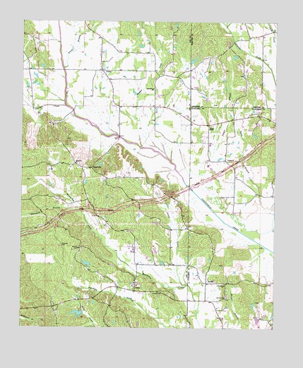
Ratliff, MS USGS Topographic Map
Click on map above to begin viewing in our Map Viewer.

This topographic map contains these locations and features:
Feature Name Type Latitude Longitude GNIS ID View Map
Carnes School (historical)SchoolN34.4718°W88.5601°686962View Map
ChapelvillePopulated PlaceN34.4401°W88.5909°668340View Map
Church of GodChurchN34.3890°W88.5559°668475View Map
Dugger CreekStreamN34.4440°W88.5523°669487View Map
East Mount Zion ChurchChurchN34.4726°W88.5601°669595View Map
Franklin Nichols Pond DamDamN34.3834°W88.5034°682618View Map
Franklin Nichols Pond DamDamN34.3868°W88.5050°682621View Map
Friendship CemeteryCemeteryN34.4418°W88.6000°706755View Map
Friendship ChurchChurchN34.4420°W88.5987°670245View Map
Horton-Bailey CemeteryCemeteryN34.4620°W88.6153°706761View Map
New Dawn ChurchChurchN34.4584°W88.5009°674610View Map
Oak Grove CemeteryCemeteryN34.3907°W88.5195°706261View Map
Oak Grove ChurchChurchN34.3870°W88.5242°675058View Map
Oak Grove ChurchChurchN34.3923°W88.5245°675059View Map
Okeelala CreekStreamN34.4654°W88.6031°675152View Map
Old Friendship CemeteryCemeteryN34.4418°W88.5981°706780View Map
Palestine ChurchChurchN34.4432°W88.5234°675406View Map
Palestine School (historical)SchoolN34.4437°W88.5251°683703View Map
Parkers ChapelChurchN34.4565°W88.5326°675464View Map
Penny CreekStreamN34.3929°W88.5431°675595View Map
Peterson CemeteryCemeteryN34.4087°W88.6048°675656View Map
Plumorchard BranchStreamN34.4982°W88.5245°676157View Map
Pratt School (historical)SchoolN34.4790°W88.5856°706797View Map
PrattsPopulated PlaceN34.4801°W88.5853°676317View Map
Pratts CemeteryCemeteryN34.4779°W88.5864°706798View Map
Pratts ChurchChurchN34.4798°W88.5862°706799View Map
Pritchard Lake DamDamN34.4734°W88.5717°682659View Map
RatliffPopulated PlaceN34.3934°W88.5337°676478View Map
Red Hill CemeteryCemeteryN34.4076°W88.5970°676531View Map
Red Hill School (historical)SchoolN34.4079°W88.5964°684568View Map
Silver BranchStreamN34.4807°W88.6048°677789View Map
South Prentiss ChurchChurchN34.4948°W88.5134°678009View Map
South Prentiss School (historical)SchoolN34.4948°W88.5120°683674View Map
Supervisor District 1CivilN34.3791°W88.6166°711953View Map
Tennelue CemeteryCemeteryN34.4723°W88.6212°706814View Map
Tennie Lou Church (historical)ChurchN34.4726°W88.6203°684600View Map
Threemile BranchStreamN34.4229°W88.5959°678738View Map
UnityPopulated PlaceN34.3901°W88.5689°679129View Map
Unity CemeteryCemeteryN34.3926°W88.5695°706822View Map
Unity ChurchChurchN34.3934°W88.5687°684617View Map
Whitley School (historical)SchoolN34.4148°W88.5517°684630View Map
Yeager BranchStreamN34.4082°W88.5020°679929View Map

Note: Coordinates in the location and feature list above are referenced to NAD83 datum.


Copyright (C) 2008-2024 Ryan Niemi / Sunset Dynamics ... All Rights Reserved