TopoQuest Logo
Do you find TopoQuest useful?
Help keep TopoQuest running and adding new maps/features by donating!
Bitcoin:  19c7KJd3qBynnjoSw5npx9KScwjBe4ifkT
Litecoin:  LXs6TkuXGGXo1vDsWCkWVdjQX94eUKd6ui
Home View Maps Find Maps Find Places Resources & Links


Jasper West, Texas Topographic Map

USGS Map Title: Jasper West, TX
USGS Map MRC: 30094H1
DRG (GeoTIFF) Download: o30094h1.tif


Neighboring USGS Topographic Map Quads:


  Ebenezer, TX  
31094A2
 

  McGee Bend, TX  
31094A1
 

  Harrisburg, TX  
31093A8
 

  Pace Hill, TX  
30094H2
 

  Jasper West, TX  
30094H1
 

  Jasper East, TX  
30093H8
 

  Town Bluff, TX  
30094G2
 

  Beech Grove, TX  
30094G1
 

  Roganville, TX  
30093G8


Map MRC Location:

N31°
W95°
N31°
W94°
H8 H7 H6 H5 H4 H3 H2 H1
G8 G7 G6 G5 G4 G3 G2 G1
F8 F7 F6 F5 F4 F3 F2 F1
E8 E7 E6 E5 E4 E3 E2 E1
D8 D7 D6 D5 D4 D3 D2 D1
C8 C7 C6 C5 C4 C3 C2 C1
B8 B7 B6 B5 B4 B3 B2 B1
A8 A7 A6 A5 A4 A3 A2 A1
N30°
W95°
N30°
W94°

Jasper West, TX USGS 1:24K Topographic Map Preview:
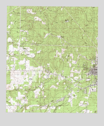
Jasper West, TX USGS Topographic Map
Click on map above to begin viewing in our Map Viewer.

This topographic map contains these locations and features:
Feature Name Type Latitude Longitude GNIS ID View Map
Adams Memorial ChurchChurchN30.8871°W94.0127°1350876View Map
Beech Grove SchoolSchoolN30.9202°W94.0646°1351785View Map
Beech Grove SchoolSchoolN30.9252°W94.1196°1351786View Map
Blue Spring BranchStreamN30.9533°W94.0144°1352493View Map
Boggy BranchStreamN30.9141°W94.0432°1352566View Map
Brooks PondLakeN30.9435°W94.0955°1352943View Map
Brown BranchStreamN30.9460°W94.0044°1352958View Map
Bulldog FieldParkN30.9005°W94.0102°2028145View Map
Byerly CemeteryCemeteryN30.9077°W94.0744°1829131View Map
Campground CemeteryCemeteryN30.9074°W94.0738°1353704View Map
CHRISTUS Jasper Memorial HospitalHospitalN30.9080°W94.0095°2015796View Map
Colonel Randolph C Doom HouseBuildingN30.9238°W94.1244°2031385View Map
Coon BranchStreamN30.9330°W94.0307°1354921View Map
Coon CreekStreamN30.9130°W94.0213°1370144View Map
CurtisPopulated PlaceN30.9213°W94.0646°1379622View Map
Deep East Texas Council of GovernmentsBuildingN30.9083°W94.0155°2630592View Map
Dixie Community ChurchChurchN30.9321°W94.1244°1381768View Map
Flournoy LakeLakeN30.9235°W94.0149°1357501View Map
Gilgal CemeteryCemeteryN30.9274°W94.0182°1358028View Map
Gillgal ChurchChurchN30.9344°W94.0388°1358024View Map
Good CemeteryCemeteryN30.9444°W94.0088°1358145View Map
Goodman BranchStreamN30.9741°W94.1132°1358154View Map
Graham ChurchChurchN30.9588°W94.0980°1358246View Map
Hadnot CemeteryCemeteryN30.9408°W94.0755°1358617View Map
Hall CemeteryCemeteryN30.9733°W94.1180°1358666View Map
Hancock CemeteryCemeteryN30.9771°W94.0935°1358717View Map
Indian CreekStreamN30.9791°W94.0613°1380954View Map
Jasper City HallBuildingN30.9166°W94.0008°2753244View Map
Jasper County Airport-Bell FieldAirportN30.8916°W94.0361°1384812View Map
Jasper County Constable's Office Precinct 2BuildingN30.9213°W94.0000°2751326View Map
Jasper DivisionCivilN30.9742°W94.0601°1938865View Map
Jasper Middle SchoolSchoolN30.9213°W94.0085°2006218View Map
Jasper Police DepartmentBuildingN30.9155°W94.0008°2751153View Map
Jasper Post OfficePost OfficeN30.9217°W94.0028°2732256View Map
Jasper Volunteer Fire Department Station 2BuildingN30.8970°W94.0326°2655396View Map
Lanier CemeteryCemeteryN30.8799°W94.1052°1360944View Map
Linsey LakeReservoirN30.9435°W94.0819°1861995View Map
Linsey Lake DamDamN30.9435°W94.0819°1861994View Map
Little Hope CemeteryCemeteryN30.9024°W94.1113°1829132View Map
Lone Star ChurchChurchN30.9021°W94.0269°1361666View Map
Med Trans Southeast Texas Air Rescue 2BuildingN30.9073°W94.0125°2721017View Map
Moore Chapel ChurchChurchN30.9113°W94.0016°2020775View Map
Moore ChurchChurchN30.9119°W94.0646°1363104View Map
Morgan-Lindsey LakesReservoirN30.9828°W94.0422°1363149View Map
Nazarene ChurchChurchN30.9327°W94.0019°2020776View Map
Nedville ChurchChurchN30.9258°W94.1130°1363635View Map
Needle Grove ChurchChurchN30.9249°W94.1180°1363637View Map
New Hope ChurchChurchN30.9024°W94.1085°1363731View Map
Neyland CreekStreamN30.9152°W94.0335°1363871View Map
Parnell Elementary SchoolSchoolN30.9213°W94.0116°2007189View Map
Pattons PondLakeN30.9415°W94.0423°1364892View Map
Pattons Pond DamDamN30.9385°W94.0419°1861996View Map
Peach Tree ChurchChurchN30.9530°W94.1010°1364930View Map
Ryalis CemeteryCemeteryN30.9110°W94.0441°1367058View Map
Sandy Creek ParkParkN30.9188°W94.0021°2029346View Map
Sunflower ChurchChurchN30.9569°W94.0777°1369399View Map
Texas Department of Public Safety - Highway Patrol OfficeBuildingN30.8981°W94.0356°2751529View Map
Trotti CemeteryCemeteryN30.9180°W94.0221°1370143View Map
Watts - Fuller CemeteryCemeteryN30.9971°W94.0710°1370951View Map
West Lake ChurchChurchN30.9627°W94.0507°1371169View Map
White BranchStreamN30.9713°W94.1160°1371352View Map
Yates CemeteryCemeteryN30.9549°W94.1171°1372018View Map

Note: Coordinates in the location and feature list above are referenced to NAD83 datum.


Copyright (C) 2008-2024 Ryan Niemi / Sunset Dynamics ... All Rights Reserved