TopoQuest Logo
Do you find TopoQuest useful?
Help keep TopoQuest running and adding new maps/features by donating!
Bitcoin:  19c7KJd3qBynnjoSw5npx9KScwjBe4ifkT
Litecoin:  LXs6TkuXGGXo1vDsWCkWVdjQX94eUKd6ui
Home View Maps Find Maps Find Places Resources & Links


Pace Hill, Texas Topographic Map

USGS Map Title: Pace Hill, TX
USGS Map MRC: 30094H2
DRG (GeoTIFF) Download: o30094h2.tif


Neighboring USGS Topographic Map Quads:


  Boykin Spring, TX  
31094A3
 

  Ebenezer, TX  
31094A2
 

  McGee Bend, TX  
31094A1
 

  Boggy Lake, TX  
30094H3
 

  Pace Hill, TX  
30094H2
 

  Jasper West, TX  
30094H1
 

  Birdwell Lake, TX  
30094G3
 

  Town Bluff, TX  
30094G2
 

  Beech Grove, TX  
30094G1


Map MRC Location:

N31°
W95°
N31°
W94°
H8 H7 H6 H5 H4 H3 H2 H1
G8 G7 G6 G5 G4 G3 G2 G1
F8 F7 F6 F5 F4 F3 F2 F1
E8 E7 E6 E5 E4 E3 E2 E1
D8 D7 D6 D5 D4 D3 D2 D1
C8 C7 C6 C5 C4 C3 C2 C1
B8 B7 B6 B5 B4 B3 B2 B1
A8 A7 A6 A5 A4 A3 A2 A1
N30°
W95°
N30°
W94°

Pace Hill, TX USGS 1:24K Topographic Map Preview:
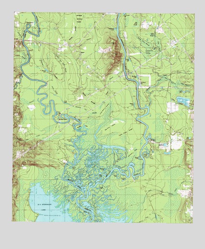
Pace Hill, TX USGS Topographic Map
Click on map above to begin viewing in our Map Viewer.

This topographic map contains these locations and features:
Feature Name Type Latitude Longitude GNIS ID View Map
Adams LakeLakeN30.9465°W94.1663°1381292View Map
Andrew Smyth HouseBuildingN30.9355°W94.1444°2031572View Map
Angelina RiverStreamN30.8946°W94.1977°1383018View Map
Angelina River Volunteer Fire DepartmentBuildingN30.9926°W94.1481°2655367View Map
Barrow LakeLakeN30.9655°W94.2273°1381358View Map
Bee Tree SwampSwampN30.9238°W94.1898°1381381View Map
Bevelport ReservoirReservoirN30.9219°W94.1447°1381411View Map
Bevelport Townsite Historical MonumentParkN30.9244°W94.1549°1381412View Map
BevilportPopulated PlaceN30.9233°W94.1552°1383669View Map
Big Boyd LakeLakeN30.9619°W94.1643°1381416View Map
Big EddyLakeN30.9371°W94.2074°1381425View Map
Big Pine IslandIslandN30.9291°W94.1849°1381430View Map
Boggy BranchStreamN30.9541°W94.1835°1381474View Map
Buster LakeLakeN30.9133°W94.1627°1381559View Map
Dallas BranchStreamN30.8919°W94.1374°1383074View Map
Deep SloughStreamN30.9488°W94.2163°1381753View Map
Devils SloughStreamN30.9494°W94.1982°1381757View Map
Dies LakeLakeN30.9261°W94.1277°1381763View Map
Doctor Steven H Everitt Historical MonumentParkN30.9135°W94.1255°1381773View Map
Ellis Pond SloughSwampN30.9923°W94.1654°1381839View Map
Farrell CemeteryCemeteryN30.9183°W94.2399°1381863View Map
Flat BranchStreamN30.9780°W94.2099°1381875View Map
Fox LandingPopulated PlaceN30.9910°W94.2380°1383667View Map
Frank Camp RidgeRidgeN30.9266°W94.1702°1381894View Map
Grass Pond SloughSwampN30.9874°W94.1546°1381938View Map
Grimes LakeLakeN30.9075°W94.2096°1381949View Map
Gum SloughSwampN30.9796°W94.1495°1381952View Map
Hamilton LakeLakeN30.8996°W94.1727°1381962View Map
HomerPopulated PlaceN30.9766°W94.2044°1383668View Map
Homer ChurchChurchN30.9730°W94.2044°1382019View Map
Hopson Mill CreekStreamN30.9346°W94.2194°1382028View Map
Horse LakeLakeN30.8952°W94.1902°1382031View Map
Horseshoe LakeLakeN30.9911°W94.1803°1382032View Map
Huddley LakesLakeN30.9319°W94.1996°1382042View Map
Indian CreekStreamN30.9438°W94.1560°1382059View Map
Jasper State Fish HatcheryLocaleN30.9474°W94.1282°1384582View Map
Jim Goode LakeLakeN30.9998°W94.1740°1383114View Map
Johns BranchStreamN30.9466°W94.2313°1383115View Map
Johnson FlatsFlatN30.9149°W94.1702°1382087View Map
Kelly BranchStreamN30.8877°W94.1630°1382100View Map
Lindsey BranchStreamN30.9721°W94.2396°1382158View Map
Lingo LakeLakeN30.9538°W94.1312°1382159View Map
Lingo Lake DamDamN30.9535°W94.1335°1861998View Map
Little Boyd LakeLakeN30.9587°W94.1632°1382162View Map
Little Pine IslandIslandN30.9402°W94.1857°1382181View Map
Long LakeLakeN30.9460°W94.2135°1382196View Map
Louis CreekStreamN30.9613°W94.1441°1383128View Map
Lynch HillSummitN30.9827°W94.1788°1382213View Map
May Haw Pond SloughStreamN30.9419°W94.2071°1382244View Map
Moon LakeLakeN30.9027°W94.1771°1382319View Map
Mulberry Flat SloughGutN30.9430°W94.2077°1382364View Map
Neyland LakeLakeN30.9066°W94.1855°1382396View Map
Old River LakesLakeN30.9388°W94.2135°1382431View Map
Old River Woodland TrailTrailN30.9155°W94.1580°2033320View Map
Overton LakeReservoirN30.9233°W94.2090°1343371View Map
Ox Lot LakeLakeN30.9244°W94.2091°1382445View Map
Pace HillSummitN30.9755°W94.1794°1382447View Map
Pamplin CreekStreamN30.9635°W94.2435°1382452View Map
Persimmon Pond SloughSwampN30.9763°W94.1562°1382483View Map
Pine WoodsWoodsN30.9385°W94.1988°1382518View Map
Pool BranchStreamN30.9605°W94.1449°1382550View Map
Potato Pond SloughSwampN30.9825°W94.1597°1382561View Map
Prater LakeLakeN30.9727°W94.1701°1382569View Map
Primrose SloughStreamN30.9491°W94.2163°1382573View Map
Rawls CemeteryCemeteryN30.9191°W94.2316°1382597View Map
Rocky CreekStreamN30.9835°W94.2435°1382642View Map
Seale CemeteryCemeteryN30.9446°W94.1252°1382738View Map
Shelby LakeLakeN30.9145°W94.1580°1382752View Map
Smith FerryLocaleN30.9796°W94.2424°1382778View Map
Spring CreekStreamN30.8752°W94.1641°1382794View Map
State Wildlife Scientific AreaParkN30.9274°W94.1844°2029332View Map
State Wildlife Scientific AreaParkN30.9258°W94.2110°2029333View Map
TGP 32 HeliportAirportN30.9844°W94.1377°1386952View Map
Tub LakeLakeN30.9374°W94.2202°1382882View Map
Wash LakeLakeN30.9502°W94.1849°1382923View Map
Water HoleLakeN30.9035°W94.1869°1382924View Map
Williams CreekStreamN30.9505°W94.1546°1382971View Map
Yates BranchStreamN30.9577°W94.1371°1372016View Map

Note: Coordinates in the location and feature list above are referenced to NAD83 datum.


Copyright (C) 2008-2024 Ryan Niemi / Sunset Dynamics ... All Rights Reserved