TopoQuest Logo
Do you find TopoQuest useful?
Help keep TopoQuest running and adding new maps/features by donating!
Bitcoin:  19c7KJd3qBynnjoSw5npx9KScwjBe4ifkT
Litecoin:  LXs6TkuXGGXo1vDsWCkWVdjQX94eUKd6ui
Home View Maps Find Maps Find Places Resources & Links


Jeannette, Mississippi Topographic Map

USGS Map Title: Jeannette, MS
USGS Map MRC: 31091D2
DRG (GeoTIFF) Download: o31091d2.tif


Neighboring USGS Topographic Map Quads:


  Washington, MS  
31091E3
 

  Cranfield, MS  
31091E2
 

  Roxie, MS  
31091E1
 

  Kingston, MS  
31091D3
 

  Jeannette, MS  
31091D2
 

  Knoxville, MS  
31091D1
 

  Doloroso, MS  
31091C3
 

  Garden City, MS  
31091C2
 

  Crosby, MS  
31091C1


Map MRC Location:

N32°
W92°
N32°
W91°
H8 H7 H6 H5 H4 H3 H2 H1
G8 G7 G6 G5 G4 G3 G2 G1
F8 F7 F6 F5 F4 F3 F2 F1
E8 E7 E6 E5 E4 E3 E2 E1
D8 D7 D6 D5 D4 D3 D2 D1
C8 C7 C6 C5 C4 C3 C2 C1
B8 B7 B6 B5 B4 B3 B2 B1
A8 A7 A6 A5 A4 A3 A2 A1
N31°
W92°
N31°
W91°

Jeannette, MS USGS 1:24K Topographic Map Preview:
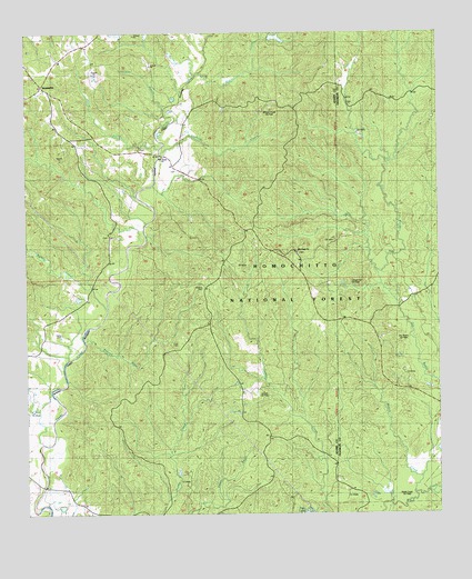
Jeannette, MS USGS Topographic Map
Click on map above to begin viewing in our Map Viewer.

This topographic map contains these locations and features:
Feature Name Type Latitude Longitude GNIS ID View Map
Bailey CreekStreamN31.3810°W91.1343°692439View Map
Beach CemeteryCemeteryN31.4813°W91.1507°707556View Map
Carter CemeteryCemeteryN31.4224°W91.2398°692846View Map
Cooper Hill Oil FieldOilfieldN31.4793°W91.1918°705170View Map
Cory CemeteryCemeteryN31.4202°W91.2045°692980View Map
Courtland Oil FieldOilfieldN31.3807°W91.2293°705171View Map
Dry Bayou Oil FieldOilfieldN31.4199°W91.1446°693112View Map
Hoggatt BranchStreamN31.4807°W91.2087°693496View Map
Holmes CemeteryCemeteryN31.4343°W91.1968°693511View Map
JeannettePopulated PlaceN31.4866°W91.2448°693605View Map
Leesdale Lookout TowerTowerN31.4768°W91.1704°711265View Map
Leesdale Tower Oil FieldOilfieldN31.4741°W91.1496°705583View Map
Levees Oil FieldOilfieldN31.4052°W91.1868°693714View Map
Locust Hill Oil FieldOilfieldN31.4360°W91.1609°693805View Map
Moorland Oil FieldOilfieldN31.4057°W91.2473°705177View Map
Mount Plain ChurchChurchN31.4477°W91.2254°694090View Map
Natchez Coravel PitsFlatN31.4913°W91.2407°705649View Map
New Hope ChurchChurchN31.4435°W91.1696°694171View Map
North Pelucid Bayou Oil FieldOilfieldN31.4307°W91.2015°705179View Map
Odum BayouStreamN31.4704°W91.2107°694249View Map
Pellucid BayouStreamN31.4210°W91.2329°694337View Map
Pellucid Bayou Oil FieldOilfieldN31.4182°W91.2029°705180View Map
Pine Grove ChurchChurchN31.4679°W91.2101°694380View Map
Pipes Lake DamDamN31.4885°W91.1751°695395View Map
Pipes Lake Recreation AreaParkN31.3763°W91.1648°711535View Map
Pretty Creek Oil FieldOilfieldN31.3918°W91.2182°705181View Map
Sandy Creek State Creek Wildlife Management AreaParkN31.4002°W91.2168°705185View Map
South Jeannette Oil FieldOilfieldN31.4779°W91.2418°705187View Map
Supervisor District 3CivilN31.4772°W91.2349°711761View Map
Swafford BranchStreamN31.4685°W91.2107°694911View Map
Turkey CreekStreamN31.4288°W91.2259°695019View Map
Webb Carter Junior Lake DamDamN31.3868°W91.2484°695374View Map
Wells Creek Oil FieldOilfieldN31.3782°W91.1462°695117View Map
West Deerfield Oil FieldOilfieldN31.3754°W91.2140°705193View Map
West Locust Hill Oil FieldOilfieldN31.4363°W91.1862°705194View Map
Whites CreekStreamN31.4902°W91.1993°695161View Map
Whites Creek Oil FieldOilfieldN31.4793°W91.1765°705294View Map

Note: Coordinates in the location and feature list above are referenced to NAD83 datum.


Copyright (C) 2008-2024 Ryan Niemi / Sunset Dynamics ... All Rights Reserved