TopoQuest Logo
Do you find TopoQuest useful?
Help keep TopoQuest running and adding new maps/features by donating!
Bitcoin:  19c7KJd3qBynnjoSw5npx9KScwjBe4ifkT
Litecoin:  LXs6TkuXGGXo1vDsWCkWVdjQX94eUKd6ui
Home View Maps Find Maps Find Places Resources & Links


Jefferson NE, South Carolina Topographic Map

USGS Map Title: Jefferson NE, SC
USGS Map MRC: 34080F3
DRG (GeoTIFF) Download: o34080f3.tif


Neighboring USGS Topographic Map Quads:


  Pageland, SC  
34080G4
 

  Hornsboro, SC  
34080G3
 

  Mount Croghan, SC  
34080G2
 

  Jefferson, SC  
34080F4
 

  Jefferson NE, SC  
34080F3
 

  Ruby, SC  
34080F2
 

  Mount Pisgah, SC  
34080E4
 

  Angelus, SC  
34080E3
 

  Middendorf, SC  
34080E2


Map MRC Location:

N35°
W81°
N35°
W80°
H8 H7 H6 H5 H4 H3 H2 H1
G8 G7 G6 G5 G4 G3 G2 G1
F8 F7 F6 F5 F4 F3 F2 F1
E8 E7 E6 E5 E4 E3 E2 E1
D8 D7 D6 D5 D4 D3 D2 D1
C8 C7 C6 C5 C4 C3 C2 C1
B8 B7 B6 B5 B4 B3 B2 B1
A8 A7 A6 A5 A4 A3 A2 A1
N34°
W81°
N34°
W80°

Jefferson NE, SC USGS 1:24K Topographic Map Preview:
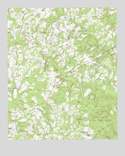
Jefferson NE, SC USGS Topographic Map
Click on map above to begin viewing in our Map Viewer.

This topographic map contains these locations and features:
Feature Name Type Latitude Longitude GNIS ID View Map
Antioch Church (historical)ChurchN34.6354°W80.2659°1235581View Map
Antioch School (historical)SchoolN34.6357°W80.2656°1235583View Map
Bethlehem ChurchChurchN34.7265°W80.3353°1220619View Map
Big BranchStreamN34.6757°W80.2728°1220678View Map
Big BranchStreamN34.7115°W80.3267°1220679View Map
Big Ruddy BranchStreamN34.6879°W80.3117°1220727View Map
Black Creek ChurchChurchN34.6932°W80.3076°1220771View Map
Black Creek School (historical)SchoolN34.6932°W80.3070°1235596View Map
Black Creek School (historical)SchoolN34.6885°W80.2528°1235597View Map
Bogey BranchStreamN34.7204°W80.3426°1220850View Map
Canal BranchStreamN34.6799°W80.3690°1221300View Map
Cattail BranchStreamN34.7418°W80.3717°1221410View Map
Center Grove Church (historical)ChurchN34.6913°W80.3615°1235612View Map
Center Grove School (historical)SchoolN34.7007°W80.3387°1235613View Map
Center School (historical)SchoolN34.7482°W80.2876°1235615View Map
Clark Mill BranchStreamN34.6646°W80.3653°1221610View Map
Clark School (historical)SchoolN34.6565°W80.3373°1244033View Map
Cotton Patch BranchStreamN34.6918°W80.3159°1221769View Map
Crawford Pond Dam D-1824DamN34.6635°W80.2915°1240007View Map
Cross of Calvary ChurchChurchN34.6524°W80.2892°1247431View Map
Dismal Spring BranchStreamN34.6518°W80.2595°1222029View Map
Dry BranchStreamN34.6638°W80.3676°1222102View Map
Evans MillPopulated PlaceN34.7268°W80.3501°1227896View Map
Fairview CemeteryCemeteryN34.7002°W80.2748°1248734View Map
Fairview ChurchChurchN34.6999°W80.2748°1247714View Map
Fork Creek CemeteryCemeteryN34.6340°W80.3742°1222490View Map
Fork Creek ChurchChurchN34.6340°W80.3742°1247798View Map
Fox BranchStreamN34.6346°W80.2998°1222530View Map
Graves MillpondReservoirN34.7388°W80.3037°1222836View Map
Gum BranchStreamN34.6677°W80.3637°1245859View Map
Hebron HillSummitN34.6607°W80.2951°1231372View Map
Horsepen BranchStreamN34.6799°W80.2965°1223339View Map
Hurricane BranchStreamN34.6790°W80.2915°1223407View Map
Jefferson DivisionCivilN34.6444°W80.3360°1938310View Map
Joplin BranchStreamN34.6779°W80.2806°1223652View Map
Joplin Mill BranchStreamN34.6749°W80.2706°1223653View Map
Jordan Mill (historical)LocaleN34.7046°W80.2523°1235687View Map
Jordans PondReservoirN34.7407°W80.3061°1237547View Map
Jumping HillsSummitN34.6960°W80.3320°1231440View Map
Knight Mill Pond Dam D-3176DamN34.6302°W80.3281°1240009View Map
Leaird Pond Dam D-3179DamN34.6618°W80.3165°1240006View Map
Little Ruddy BranchStreamN34.6863°W80.3090°1224047View Map
Long BranchStreamN34.6346°W80.3256°1224135View Map
Long Branch Baptist ChurchChurchN34.6543°W80.3409°1246459View Map
Long Branch CemeteryCemeteryN34.6542°W80.3415°1248735View Map
Mangum BranchStreamN34.7318°W80.3570°1224291View Map
Martin BranchStreamN34.7140°W80.2703°1224337View Map
Martin Pond Dam D-3178DamN34.7118°W80.2815°1240008View Map
McLeod Pond Dam D-3175DamN34.6702°W80.3565°1240011View Map
McMillan Mill (historical)LocaleN34.6740°W80.3667°1235709View Map
Meadow BranchStreamN34.6688°W80.2751°1224433View Map
Meeting House Pond Dam D-1825DamN34.6335°W80.3681°1240010View Map
Nicy Grove ChurchChurchN34.7007°W80.3370°1249871View Map
Oak Grove ChurchChurchN34.6332°W80.3598°1225107View Map
Old Mount Olive CemeteryCemeteryN34.7185°W80.3060°1225204View Map
Pageland AirportAirportN34.7421°W80.3465°1251949View Map
Panther BranchStreamN34.7010°W80.3240°1225285View Map
Peddler BranchStreamN34.7332°W80.2928°1225336View Map
Piney Grove Baptist ChurchChurchN34.7418°W80.2726°1250133View Map
Piney Grove Church (historical)ChurchN34.7443°W80.2881°1235747View Map
Rimes MillpondLakeN34.7045°W80.2540°1225888View Map
Road Branch ChurchChurchN34.6743°W80.3187°1225906View Map
Road Branch School (historical)SchoolN34.6735°W80.3184°1244035View Map
Rocky BranchStreamN34.7129°W80.3292°1225966View Map
Rocky Creek ChurchChurchN34.6446°W80.2945°1225978View Map
Rogers Pond Dam D-1828DamN34.7135°W80.3365°1239950View Map
Sandhill Volunteer Fire Department Station 1BuildingN34.6402°W80.3461°2578541View Map
Sandhill Volunteer Fire Department Station 4BuildingN34.6918°W80.2952°2578729View Map
Shady Slash BranchStreamN34.6940°W80.3634°1226526View Map
Silver RunStreamN34.6877°W80.3120°1226622View Map
South Carolina Noname 13044 D-3177 DamDamN34.7385°W80.3031°1237546View Map
Stancil LakesLakeN34.6935°W80.2720°1226861View Map
Steen Mill (historical)LocaleN34.7279°W80.2867°1235778View Map
Steen MillpondLakeN34.7287°W80.2876°1226881View Map
Still BranchStreamN34.6840°W80.3065°1226888View Map
Swamp BranchStreamN34.6382°W80.2923°1226986View Map
Sycamore PondReservoirN34.6296°W80.2802°1227008View Map
Sycamore Pond Dam D-3180DamN34.6285°W80.2815°1240004View Map
Tan Trough BranchStreamN34.6993°W80.3240°1227025View Map
Welshs Mill (historical)LocaleN34.7127°W80.2651°1235796View Map
Zion CemeteryCemeteryN34.7457°W80.3587°1248749View Map
Zion ChurchChurchN34.7468°W80.3590°1227759View Map
Zion School (historical)SchoolN34.7471°W80.3590°1235810View Map

Note: Coordinates in the location and feature list above are referenced to NAD83 datum.


Copyright (C) 2008-2024 Ryan Niemi / Sunset Dynamics ... All Rights Reserved