TopoQuest Logo
Do you find TopoQuest useful?
Help keep TopoQuest running and adding new maps/features by donating!
Bitcoin:  19c7KJd3qBynnjoSw5npx9KScwjBe4ifkT
Litecoin:  LXs6TkuXGGXo1vDsWCkWVdjQX94eUKd6ui
Home View Maps Find Maps Find Places Resources & Links


Mount Croghan, South Carolina Topographic Map

USGS Map Title: Mount Croghan, SC
USGS Map MRC: 34080G2
DRG (GeoTIFF) Download: o34080g2.tif


Neighboring USGS Topographic Map Quads:


  Marshville, NC  
34080H3
 

  Russellville, NC  
34080H2
 

  Wadesboro, NC  
34080H1
 

  Hornsboro, SC  
34080G3
 

  Mount Croghan, SC  
34080G2
 

  Morven West, NC  
34080G1
 

  Jefferson NE, SC  
34080F3
 

  Ruby, SC  
34080F2
 

  Chesterfield, SC  
34080F1


Map MRC Location:

N35°
W81°
N35°
W80°
H8 H7 H6 H5 H4 H3 H2 H1
G8 G7 G6 G5 G4 G3 G2 G1
F8 F7 F6 F5 F4 F3 F2 F1
E8 E7 E6 E5 E4 E3 E2 E1
D8 D7 D6 D5 D4 D3 D2 D1
C8 C7 C6 C5 C4 C3 C2 C1
B8 B7 B6 B5 B4 B3 B2 B1
A8 A7 A6 A5 A4 A3 A2 A1
N34°
W81°
N34°
W80°

Mount Croghan, SC USGS 1:24K Topographic Map Preview:
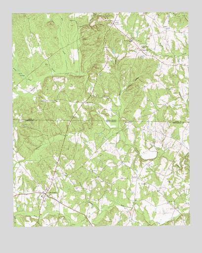
Mount Croghan, SC USGS Topographic Map
Click on map above to begin viewing in our Map Viewer.

This topographic map contains these locations and features:
Feature Name Type Latitude Longitude GNIS ID View Map
Bell CreekStreamN34.8402°W80.2112°980935View Map
Boles CreekStreamN34.8354°W80.2301°981693View Map
Buck SwampSwampN34.8407°W80.2447°982121View Map
Cedar CreekStreamN34.7879°W80.1267°982813View Map
Cedar Creek ChurchChurchN34.8299°W80.1395°982822View Map
Concordia Farms LakeReservoirN34.8524°W80.1777°998159View Map
Concordia Farms Lake DamDamN34.8518°W80.1765°998158View Map
Crews BranchStreamN34.7515°W80.1473°1247423View Map
Davidson Grove Baptist ChurchChurchN34.7640°W80.1401°1247497View Map
Davidson Grove School (historical)SchoolN34.7504°W80.1390°1235639View Map
Deadfall CreekStreamN34.8077°W80.1748°984029View Map
Deep CreekPopulated PlaceN34.8529°W80.1587°1006173View Map
Deep Creek ChurchChurchN34.8549°W80.1573°984064View Map
Deep Creek Church CemeteryCemeteryN34.8550°W80.1582°2778990View Map
Ebenezer CemeteryCemeteryN34.7604°W80.1342°1248732View Map
Ebenezer ChurchChurchN34.7602°W80.1348°1247625View Map
Elizabeth Baptist ChurchChurchN34.7804°W80.2126°1247655View Map
Elizabeth CemeteryCemeteryN34.7807°W80.2128°1248733View Map
Griggs CemeteryCemeteryN34.7760°W80.1379°1222911View Map
Grindstone CreekStreamN34.8652°W80.2034°986162View Map
Gulledge Volunteer Fire DepartmentBuildingN34.8664°W80.1431°2638656View Map
Gulpins BranchStreamN34.7610°W80.1837°1222941View Map
Jenning BranchStreamN34.7510°W80.2090°1223541View Map
Lick BranchStreamN34.8504°W80.1437°988438View Map
Littles QuartersPopulated PlaceN34.8227°W80.1992°1006281View Map
Long PinePopulated PlaceN34.8240°W80.2256°988978View Map
Long Pine ChurchChurchN34.8238°W80.2203°988979View Map
Long Pine Church CemeteryCemeteryN34.8236°W80.2198°2778991View Map
LowrysPopulated PlaceN34.8688°W80.1781°989111View Map
May BranchStreamN34.8396°W80.2153°989496View Map
MaysvillePopulated PlaceN34.8110°W80.1667°1227945View Map
Mill BranchStreamN34.7577°W80.2473°1224524View Map
Mill CreekStreamN34.7524°W80.1967°1246666View Map
Mount CroghanPopulated PlaceN34.7699°W80.2278°1249566View Map
Mount Croghan Baptist ChurchChurchN34.7688°W80.2237°1235719View Map
Mount Croghan CemeteryCemeteryN34.7689°W80.2242°1248736View Map
Mount Croghan Station (historical)LocaleN34.7596°W80.2312°1235720View Map
Muddy BranchStreamN34.7952°W80.1448°1235727View Map
Rhoddy CreekStreamN34.8202°W80.1731°993261View Map
Ruby - Mount Croghan Fire Department Station 2BuildingN34.7685°W80.2255°2578644View Map
Shaw CreekStreamN34.8385°W80.2017°994602View Map
ShoatesPopulated PlaceN34.8654°W80.1406°1006370View Map
Stillhouse BranchStreamN34.8288°W80.1726°995516View Map
Talton BranchStreamN34.7968°W80.1651°1235784View Map
Thompson Creek Baptist ChurchChurchN34.7752°W80.1567°1251158View Map
Thompsons Creek CemeteryCemeteryN34.7757°W80.1573°1248745View Map
Timmonsville Baptist ChurchChurchN34.7827°W80.1942°1251176View Map
Timmonsville School (historical)SchoolN34.7868°W80.1712°1235788View Map
Town of Mount CroghanCivilN34.7697°W80.2264°2406205View Map
Township of White StoreCivilN34.8721°W80.2481°1026378View Map
Wamble Hill Church (historical)ChurchN34.7504°W80.1273°1244039View Map
West Deep Creek ChurchChurchN34.8593°W80.1648°997003View Map
West Deep Creek Church CemeteryCemeteryN34.8596°W80.1643°2778989View Map
West Deep Creek SchoolSchoolN34.8585°W80.1656°997004View Map
WexfordPopulated PlaceN34.7782°W80.1615°1227513View Map
Wexford School (historical)SchoolN34.7777°W80.1623°1235800View Map

Note: Coordinates in the location and feature list above are referenced to NAD83 datum.


Copyright (C) 2008-2025 Ryan Niemi / Sunset Dynamics ... All Rights Reserved