TopoQuest Logo
Do you find TopoQuest useful?
Help keep TopoQuest running and adding new maps/features by donating!
Bitcoin:  19c7KJd3qBynnjoSw5npx9KScwjBe4ifkT
Litecoin:  LXs6TkuXGGXo1vDsWCkWVdjQX94eUKd6ui
Home View Maps Find Maps Find Places Resources & Links


Jeffersonton, Virginia Topographic Map

USGS Map Title: Jeffersonton, VA
USGS Map MRC: 38077F8
DRG (GeoTIFF) Download: o38077f8.tif


Neighboring USGS Topographic Map Quads:


  Flint Hill, VA  
38078G1
 

  Orlean, VA  
38077G8
 

  Marshall, VA  
38077G7
 

  Massies Corner, VA  
38078F1
 

  Jeffersonton, VA  
38077F8
 

  Warrenton, VA  
38077F7
 

  Castleton, VA  
38078E1
 

  Brandy Station, VA  
38077E8
 

  Remington, VA  
38077E7


Map MRC Location:

N39°
W78°
N39°
W77°
H8 H7 H6 H5 H4 H3 H2 H1
G8 G7 G6 G5 G4 G3 G2 G1
F8 F7 F6 F5 F4 F3 F2 F1
E8 E7 E6 E5 E4 E3 E2 E1
D8 D7 D6 D5 D4 D3 D2 D1
C8 C7 C6 C5 C4 C3 C2 C1
B8 B7 B6 B5 B4 B3 B2 B1
A8 A7 A6 A5 A4 A3 A2 A1
N38°
W78°
N38°
W77°

Jeffersonton, VA USGS 1:24K Topographic Map Preview:
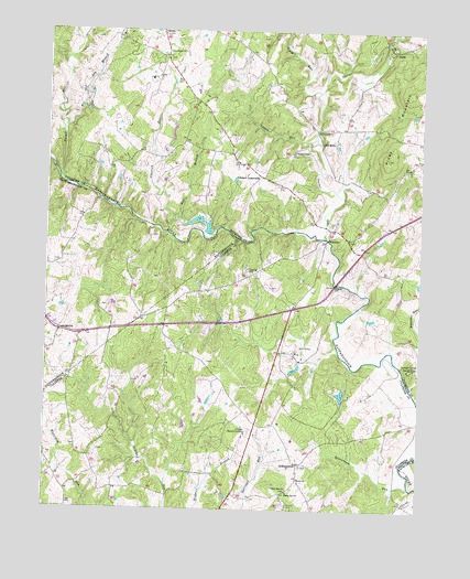
Jeffersonton, VA USGS Topographic Map
Click on map above to begin viewing in our Map Viewer.

This topographic map contains these locations and features:
Feature Name Type Latitude Longitude GNIS ID View Map
AmissvillePopulated PlaceN38.6715°W77.9956°1477071View Map
Amissville Post OfficePost OfficeN38.6684°W77.9960°2766331View Map
Beaverdam RunStreamN38.6315°W77.8778°1462970View Map
Bee BranchStreamN38.7021°W77.9550°1462992View Map
Black HillSummitN38.6385°W77.9514°1500868View Map
Carter RunStreamN38.6960°W77.9061°1464488View Map
Carter Run Church (historical)ChurchN38.7076°W77.8869°1749356View Map
Cliff MillsPopulated PlaceN38.7210°W77.9083°1495398View Map
Corbin School (historical)SchoolN38.6360°W77.9975°1497825View Map
Countryside EstatesPopulated PlaceN38.6323°W77.9200°1497826View Map
Deerfield EstatesPopulated PlaceN38.6440°W77.9433°1497844View Map
DudiePopulated PlaceN38.7451°W77.8842°1477280View Map
ErinbrookPopulated PlaceN38.6807°W77.9486°1497850View Map
Fauquier Springs Country ClubLocaleN38.6618°W77.8786°1491146View Map
First Baptist ChurchChurchN38.6957°W77.8989°1749368View Map
First Baptist ChurchChurchN38.6960°W77.8992°1749370View Map
Fox Acres AirportAirportN38.7229°W77.9003°1498843View Map
Glascock RunStreamN38.6968°W77.9433°1467132View Map
Glascock Run DamDamN38.6968°W77.9464°1489733View Map
Harts CrossroadsLocaleN38.6926°W77.8944°1749380View Map
Hillcrest Memory GardensCemeteryN38.6451°W77.9311°1468054View Map
JeffersontonPopulated PlaceN38.6371°W77.9150°1477444View Map
Jeffersonton Baptist ChurchChurchN38.6365°W77.9139°1497863View Map
Jeffersonton Post OfficePost OfficeN38.6335°W77.9144°2766230View Map
Johnson DamDamN38.7168°W77.9947°1489698View Map
Johnson PondReservoirN38.7168°W77.9947°1489699View Map
Locust RunStreamN38.7223°W77.9100°1469733View Map
MageePopulated PlaceN38.6837°W77.9303°1497870View Map
Miller LakeReservoirN38.7148°W77.8793°1489534View Map
Mission Church (historical)ChurchN38.6754°W77.9672°1497875View Map
Negro RunStreamN38.6682°W77.9025°1497882View Map
Old CondePopulated PlaceN38.7418°W77.9283°1749405View Map
Orlean Methodist Episcopal ChurchChurchN38.7487°W77.9611°1749407View Map
Palmers CrossroadsPopulated PlaceN38.7123°W77.9283°1496058View Map
Piney MountainSummitN38.7171°W77.8861°1472409View Map
Piney Mountain School (historical)SchoolN38.7248°W77.9031°1749414View Map
Providence ChurchChurchN38.7446°W77.9597°1472838View Map
Rising Zion ChurchChurchN38.6296°W77.9181°1473256View Map
South ChurchChurchN38.6332°W77.9147°1474845View Map
South RunStreamN38.7343°W77.9089°1474899View Map
South WalesPopulated PlaceN38.6637°W77.9256°1497907View Map
South Wales Country Club DamDamN38.6635°W77.9164°1489526View Map
South Wales Country Club LakeReservoirN38.6619°W77.9165°1489527View Map
South Wales Golf CourseLocaleN38.6676°W77.9125°1497908View Map
Thumb RunStreamN38.7118°W77.9961°1475697View Map
Upper Zion ChurchChurchN38.6307°W77.9183°1476123View Map
WaterlooPopulated PlaceN38.6960°W77.9061°1496378View Map
Waterloo BridgeBridgeN38.6960°W77.9061°1749447View Map
Waterloo School (historical)SchoolN38.6960°W77.8992°1749448View Map
Wesley ChapelChurchN38.7187°W77.9172°1476459View Map
Wet and Dry BranchStreamN38.7248°W77.9942°1476539View Map

Note: Coordinates in the location and feature list above are referenced to NAD83 datum.


Copyright (C) 2008-2024 Ryan Niemi / Sunset Dynamics ... All Rights Reserved