TopoQuest Logo
Do you find TopoQuest useful?
Help keep TopoQuest running and adding new maps/features by donating!
Bitcoin:  19c7KJd3qBynnjoSw5npx9KScwjBe4ifkT
Litecoin:  LXs6TkuXGGXo1vDsWCkWVdjQX94eUKd6ui
Home View Maps Find Maps Find Places Resources & Links


Marshall, Virginia Topographic Map

USGS Map Title: Marshall, VA
USGS Map MRC: 38077G7
DRG (GeoTIFF) Download: o38077g7.tif


Neighboring USGS Topographic Map Quads:


  Upperville, VA  
38077H8
 

  Rectortown, VA  
38077H7
 

  Middleburg, VA  
38077H6
 

  Orlean, VA  
38077G8
 

  Marshall, VA  
38077G7
 

  Thoroughfare Gap, VA  
38077G6
 

  Jeffersonton, VA  
38077F8
 

  Warrenton, VA  
38077F7
 

  Catlett, VA  
38077F6


Map MRC Location:

N39°
W78°
N39°
W77°
H8 H7 H6 H5 H4 H3 H2 H1
G8 G7 G6 G5 G4 G3 G2 G1
F8 F7 F6 F5 F4 F3 F2 F1
E8 E7 E6 E5 E4 E3 E2 E1
D8 D7 D6 D5 D4 D3 D2 D1
C8 C7 C6 C5 C4 C3 C2 C1
B8 B7 B6 B5 B4 B3 B2 B1
A8 A7 A6 A5 A4 A3 A2 A1
N38°
W78°
N38°
W77°

Marshall, VA USGS 1:24K Topographic Map Preview:
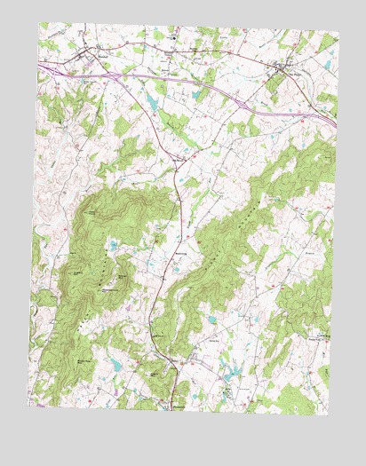
Marshall, VA USGS Topographic Map
Click on map above to begin viewing in our Map Viewer.

This topographic map contains these locations and features:
Feature Name Type Latitude Longitude GNIS ID View Map
AirliePopulated PlaceN38.7571°W77.7917°1495186View Map
Airlie AirportAirportN38.7572°W77.7875°1498837View Map
Airlie DamDamN38.7601°W77.7914°1489719View Map
Airlie LakeReservoirN38.7630°W77.7900°1489720View Map
Bellevue Farms Dam Number ThreeDamN38.7751°W77.8497°1489734View Map
BelvoirPopulated PlaceN38.8596°W77.8203°1495258View Map
Belvoir Assembly of God ChurchChurchN38.8634°W77.8200°1749345View Map
Belvoir Farm DamDamN38.8551°W77.8064°1489737View Map
Belvoir Farm LakeReservoirN38.8551°W77.8064°1489738View Map
BethelPopulated PlaceN38.7662°W77.8158°1495262View Map
Bethel Church (historical)ChurchN38.7718°W77.8053°1749346View Map
Bethel School (historical)SchoolN38.7629°W77.8311°1749347View Map
Bethel United Methodist ChurchChurchN38.7684°W77.8078°1749348View Map
Bowmans DamDamN38.8484°W77.8264°1489700View Map
Bowmans PondReservoirN38.8501°W77.8267°1489701View Map
Brookes CornerPopulated PlaceN38.8668°W77.8189°1495304View Map
Bunker HillPopulated PlaceN38.8671°W77.8069°1749352View Map
Bunker HillSummitN38.8662°W77.8094°1495335View Map
EdwardsvillePopulated PlaceN38.8346°W77.8078°1749364View Map
England MountainSummitN38.7937°W77.8578°1466303View Map
Enon ChurchChurchN38.8001°W77.8594°1466318View Map
First Baptist ChurchChurchN38.8657°W77.7708°1749369View Map
FletchervillePopulated PlaceN38.7512°W77.8150°1495545View Map
Foster ForkPopulated PlaceN38.7748°W77.7533°1495560View Map
Foster Hill School (historical)SchoolN38.8726°W77.7661°1749371View Map
Fox DamDamN38.7801°W77.7980°1489721View Map
Fox PondReservoirN38.7802°W77.7992°1489722View Map
Frye HouseBuildingN38.8665°W77.8547°1749373View Map
Grace Episcopal ChurchChurchN38.8621°W77.7761°1749376View Map
Great Meadow ParkParkN38.8290°W77.8125°1749377View Map
Groomes CrossroadsLocaleN38.7515°W77.7836°1749378View Map
Halls PointSummitN38.8137°W77.8522°1467675View Map
Horner RunStreamN38.8093°W77.8703°1468249View Map
Interchange 27CrossingN38.8593°W77.8678°1749385View Map
Interchange 28CrossingN38.8584°W77.8442°1749386View Map
Interchange 31CrossingN38.8501°W77.7894°1749387View Map
Johnsons DamDamN38.7618°W77.8364°1489717View Map
Johnsons PondReservoirN38.7644°W77.8382°1489718View Map
Little Zion ChurchChurchN38.7743°W77.8236°1469702View Map
Littte Graces PreschoolSchoolN38.8621°W77.7760°2465508View Map
MarshallPopulated PlaceN38.8648°W77.8578°1495902View Map
Marshall Census Designated PlaceCensusN38.8661°W77.8452°2584876View Map
Marshall Methodist Episcopal ChurchChurchN38.8634°W77.8594°1749393View Map
Marshall Middle SchoolSchoolN38.8735°W77.8174°1749392View Map
Marshall Post OfficePost OfficeN38.8649°W77.8569°1749394View Map
Marshall Vocational SchoolSchoolN38.8687°W77.8553°1749395View Map
Marshall Volunteer Fire Department Company 3BuildingN38.8669°W77.8554°2075394View Map
Marshall Volunteer Rescue SquadBuildingN38.8622°W77.8639°2075400View Map
Marshall Volunteer Rescue Squad Company 9BuildingN38.8622°W77.8639°2331768View Map
MeadowvillePopulated PlaceN38.7982°W77.8153°1495927View Map
Merry Oak DamDamN38.8018°W77.8414°1489735View Map
Merry Oak LakeReservoirN38.8032°W77.8410°1489736View Map
Old TavernPopulated PlaceN38.8315°W77.8119°1496047View Map
Piedmont HeightsPopulated PlaceN38.8718°W77.8581°1749411View Map
Pignut MountainSummitN38.7934°W77.8019°1496081View Map
Piney BranchStreamN38.8332°W77.8022°1472383View Map
Prickly Pear MountainSummitN38.7648°W77.8553°1496115View Map
Public School Number 18 (historical)SchoolN38.8696°W77.8317°1749416View Map
Rappahannock MountainSummitN38.7887°W77.8455°1472986View Map
Road IslandLocaleN38.7629°W77.8122°1749417View Map
RosstownPopulated PlaceN38.8668°W77.8453°1749420View Map
Saint Marks United Methodist ChurchChurchN38.8607°W77.7725°1749423View Map
Salem Baptist ChurchChurchN38.8662°W77.8456°1749426View Map
Salem StationLocaleN38.8673°W77.8494°1749427View Map
Scott DistrictCivilN38.8636°W77.7626°1927490View Map
Second Mount Morris ChurchChurchN38.7748°W77.7508°1474146View Map
Stephensons HillSummitN38.8593°W77.8603°1749430View Map
Taylors Church (historical)ChurchN38.7573°W77.8142°1749431View Map
The John Marshall LibraryBuildingN38.8687°W77.8553°2043110View Map
The Meadows AirportAirportN38.7725°W77.7960°1498838View Map
The PlainsPopulated PlaceN38.8621°W77.7739°1496309View Map
The Plains Baptist ChurchChurchN38.8593°W77.7769°1749432View Map
The Plains Post OfficePost OfficeN38.8615°W77.7753°1749433View Map
The Plains Volunteer Fire and Rescue Company 4BuildingN38.8627°W77.7727°2075395View Map
Town of The PlainsCivilN38.8620°W77.7745°2391443View Map
W G Coleman Elementary SchoolSchoolN38.8710°W77.8184°1465090View Map
Wakefield SchoolSchoolN38.8551°W77.7752°2465343View Map
Walkers CornerLocaleN38.8446°W77.8275°1749438View Map
Waters MountainSummitN38.7615°W77.8247°1476376View Map
Watery MountainsRangeN38.7840°W77.8480°1476378View Map
WavelandBuildingN38.8307°W77.8567°1749450View Map
Wheatland (historical)BuildingN38.8096°W77.8594°1749451View Map
Wildcat MountainSummitN38.7923°W77.8389°1496420View Map
Willow DamDamN38.8634°W77.7547°1489739View Map
Willow LakeReservoirN38.8639°W77.7543°1489740View Map
WMJR-FM (Warrenton)TowerN38.7926°W77.8389°1499011View Map

Note: Coordinates in the location and feature list above are referenced to NAD83 datum.


Copyright (C) 2008-2024 Ryan Niemi / Sunset Dynamics ... All Rights Reserved