TopoQuest Logo
Do you find TopoQuest useful?
Help keep TopoQuest running and adding new maps/features by donating!
Bitcoin:  19c7KJd3qBynnjoSw5npx9KScwjBe4ifkT
Litecoin:  LXs6TkuXGGXo1vDsWCkWVdjQX94eUKd6ui
Home View Maps Find Maps Find Places Resources & Links


Jemez Pueblo, New Mexico Topographic Map

USGS Map Title: Jemez Pueblo, NM
USGS Map MRC: 35106E6
DRG (GeoTIFF) Download: o35106e6.tif


Neighboring USGS Topographic Map Quads:


  Gilman, NM  
35106F7
 

  Ponderosa, NM  
35106F6
 

  Bear Springs Peak, NM  
35106F5
 

  San Ysidro, NM  
35106E7
 

  Jemez Pueblo, NM  
35106E6
 

  Loma Creston, NM  
35106E5
 

  Cerro Conejo, NM  
35106D7
 

  Bernalillo NW, NM  
35106D6
 

  Santa Ana Pueblo, NM  
35106D5


Map MRC Location:

N36°
W107°
N36°
W106°
H8 H7 H6 H5 H4 H3 H2 H1
G8 G7 G6 G5 G4 G3 G2 G1
F8 F7 F6 F5 F4 F3 F2 F1
E8 E7 E6 E5 E4 E3 E2 E1
D8 D7 D6 D5 D4 D3 D2 D1
C8 C7 C6 C5 C4 C3 C2 C1
B8 B7 B6 B5 B4 B3 B2 B1
A8 A7 A6 A5 A4 A3 A2 A1
N35°
W107°
N35°
W106°

Jemez Pueblo, NM USGS 1:24K Topographic Map Preview:
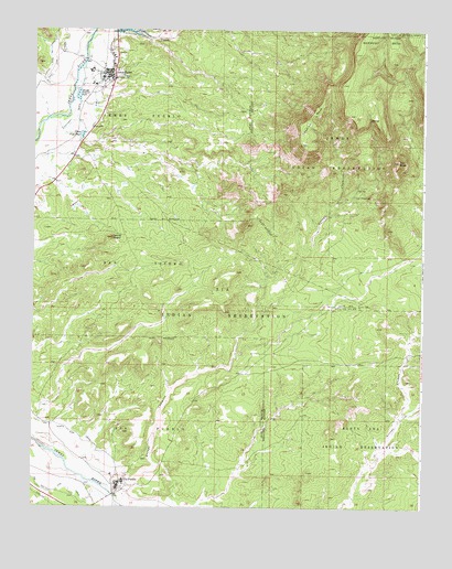
Jemez Pueblo, NM USGS Topographic Map
Click on map above to begin viewing in our Map Viewer.

This topographic map contains these locations and features:
Feature Name Type Latitude Longitude GNIS ID View Map
12345 'Proposed' Water WellWellN35.5083°W106.7167°921921View Map
4 IRR Water WellWellN35.6111°W106.7389°921895View Map
Anthony Pecos DitchCanalN35.6025°W106.7361°903201View Map
Arroyo ChamisaArroyoN35.5014°W106.7214°918050View Map
Cerrito NegroSummitN35.5703°W106.7250°918129View Map
Chamisa MesaSummitN35.6025°W106.6589°905020View Map
Community Presbyterian ChurchChurchN35.6139°W106.7259°920548View Map
Dug Water WellWellN35.5125°W106.7150°921924View Map
East Side CanalCanalN35.6231°W106.7245°918171View Map
Indian SpringsMineN35.6084°W106.7256°915604View Map
Jemez Day SchoolSchoolN35.6139°W106.7259°934176View Map
Jemez Mountains Historical MarkerParkN35.6139°W106.7259°932317View Map
Jemez PuebloCivilN35.6077°W106.7423°916031View Map
Jemez PuebloPopulated PlaceN35.6139°W106.7259°928742View Map
Jemez Pueblo Census Designated PlaceCensusN35.6066°W106.7333°2408443View Map
Jemez Pueblo Community LibraryBuildingN35.6025°W106.7100°930515View Map
Jemez Pueblo Emergency Medical ServicesBuildingN35.6030°W106.7287°2657674View Map
Jemez Pueblo GrantCivilN35.6125°W106.7356°918207View Map
Jemez Pueblo Post OfficePost OfficeN35.6085°W106.7263°938065View Map
Jemez Valley Elementary SchoolSchoolN35.6139°W106.7259°933846View Map
Jemez Valley Middle SchoolSchoolN35.6139°W106.7259°934208View Map
Ko-ah'-sai-ya RuinLocaleN35.5070°W106.7203°936046View Map
Ojo ChamisaSpringN35.5816°W106.6471°915871View Map
Pico ButteSummitN35.5906°W106.6331°909615View Map
Pueblo of Jemez Historical MarkerParkN35.6139°W106.7259°931647View Map
RWP-7 Water WellWellN35.5117°W106.7128°921922View Map
RWP-9 Water WellWellN35.5520°W106.7261°921916View Map
San Diego Elem/Mid Mission SchoolSchoolN35.6139°W106.7259°934175View Map
San Ysidro PitMineN35.5903°W106.7389°916352View Map
Sheep Fish PondLakeN35.5974°W106.7349°910991View Map
Stockwell1 Water WellWellN35.5925°W106.7153°921897View Map
Vallecito CreekStreamN35.6236°W106.7314°928837View Map
West Side CanalCanalN35.6175°W106.7448°918406View Map
West Side LateralCanalN35.6173°W106.7434°918407View Map
Zia 16 Water WellWellN35.5709°W106.7423°921908View Map
ZIA 9A Water WellWellN35.5520°W106.7164°921915View Map
Zia Day SchoolSchoolN35.5070°W106.7203°934174View Map
Zia North Side CanalCanalN35.5181°W106.7336°912546View Map
ZIA PS 2 Water WellWellN35.5123°W106.7148°921923View Map
Zia PuebloPopulated PlaceN35.5070°W106.7203°928840View Map
Zia PuebloCivilN35.5025°W106.7087°1934347View Map
Zia Pueblo Census Designated PlaceCensusN35.5200°W106.7149°2409646View Map
Zia Pueblo GrantCivilN35.5206°W106.7145°912547View Map
Zia Pueblo Volunteer Fire DepartmentBuildingN35.5100°W106.7227°2657793View Map
Zia South Side CanalCanalN35.5039°W106.7364°912549View Map
ZIA-13 Water WellWellN35.5486°W106.6495°921914View Map

Note: Coordinates in the location and feature list above are referenced to NAD83 datum.


Copyright (C) 2008-2025 Ryan Niemi / Sunset Dynamics ... All Rights Reserved