TopoQuest Logo
Do you find TopoQuest useful?
Help keep TopoQuest running and adding new maps/features by donating!
Bitcoin:  19c7KJd3qBynnjoSw5npx9KScwjBe4ifkT
Litecoin:  LXs6TkuXGGXo1vDsWCkWVdjQX94eUKd6ui
Home View Maps Find Maps Find Places Resources & Links


Jericho, Arkansas Topographic Map

USGS Map Title: Jericho, AR
USGS Map MRC: 35090C2
DRG (GeoTIFF) Download: o35090c2.tif


Neighboring USGS Topographic Map Quads:


  Tyronza, AR  
35090D3
 

  Frenchmans Bayou, AR  
35090D2
 

  Pecan Point, AR  
35090D1
 

  Heafer, AR  
35090C3
 

  Jericho, AR  
35090C2
 

  Locke, TN  
35090C1
 

  Crawfordsville, AR  
35090B3
 

  West Memphis, AR  
35090B2
 

  Northwest Memphis, TN  
35090B1


Map MRC Location:

N36°
W91°
N36°
W90°
H8 H7 H6 H5 H4 H3 H2 H1
G8 G7 G6 G5 G4 G3 G2 G1
F8 F7 F6 F5 F4 F3 F2 F1
E8 E7 E6 E5 E4 E3 E2 E1
D8 D7 D6 D5 D4 D3 D2 D1
C8 C7 C6 C5 C4 C3 C2 C1
B8 B7 B6 B5 B4 B3 B2 B1
A8 A7 A6 A5 A4 A3 A2 A1
N35°
W91°
N35°
W90°

Jericho, AR USGS 1:24K Topographic Map Preview:
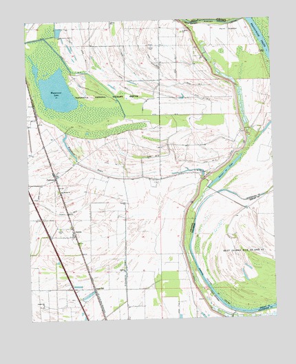
Jericho, AR USGS Topographic Map
Click on map above to begin viewing in our Map Viewer.

This topographic map contains these locations and features:
Feature Name Type Latitude Longitude GNIS ID View Map
Beef IslandFlatN35.2754°W90.1426°1305072View Map
Bledsoe CemeteryCemeteryN35.3634°W90.1637°59250View Map
Bradley Landing (historical)LocaleN35.3111°W90.1583°2548748View Map
City of ClarkedaleCivilN35.2973°W90.2104°2404055View Map
ClarkedalePopulated PlaceN35.3093°W90.2362°76622View Map
Clarkedale Post OfficePost OfficeN35.3097°W90.2368°2773509View Map
Clarkedale School (historical)SchoolN35.2976°W90.2320°59247View Map
Danner LakeLakeN35.3112°W90.1493°74780View Map
Ditch Number 1CanalN35.3604°W90.2201°82019View Map
Ditch Number 1CanalN35.3687°W90.2382°82030View Map
Ditch Number 10CanalN35.3181°W90.1815°82034View Map
Ditch Number 11CanalN35.3154°W90.2073°82050View Map
Ditch Number 12CanalN35.3154°W90.1568°82061View Map
Ditch Number 13CanalN35.3320°W90.1962°70247View Map
Ditch Number 2CanalN35.3573°W90.1987°82133View Map
Ditch Number 3CanalN35.3437°W90.1848°82199View Map
Ditch Number 3CanalN35.3587°W90.1865°82200View Map
Ditch Number 4CanalN35.3523°W90.2032°82244View Map
Ditch Number 5CanalN35.3476°W90.1637°82293View Map
Ditch Number 7CanalN35.3551°W90.1731°82368View Map
Ditch Number 8CanalN35.3393°W90.2015°82392View Map
Ditch Number 8CanalN35.2945°W90.2318°82399View Map
Ditch Number 9CanalN35.2693°W90.2015°82410View Map
Ditch Number 9CanalN35.3423°W90.1609°82411View Map
Friendship CemeteryCemeteryN35.2565°W90.2437°70232View Map
Interchange 14CrossingN35.2631°W90.2284°59038View Map
Island FortyPopulated PlaceN35.2956°W90.1395°1313625View Map
Island Forty Church (historical)ChurchN35.2901°W90.1465°1325809View Map
Island Forty ChuteLakeN35.2606°W90.1565°1289081View Map
James MillPopulated PlaceN35.2629°W90.2176°57979View Map
JerichoPopulated PlaceN35.2859°W90.2270°57990View Map
Jericho Fire DepartmentBuildingN35.2883°W90.2293°2116631View Map
Jericho Police DepartmentBuildingN35.2878°W90.2292°2118565View Map
Jerusalem ChurchChurchN35.2701°W90.2018°50639View Map
Jerusalem School (historical)SchoolN35.2806°W90.1865°78881View Map
Lake Grove ChurchChurchN35.2851°W90.2282°70236View Map
Lincoln School (historical)SchoolN35.3204°W90.1829°59249View Map
Malone CemeteryCemeteryN35.2881°W90.2343°77583View Map
Mount Olive CemeteryCemeteryN35.3112°W90.1612°70238View Map
Mount Olive ChurchChurchN35.3112°W90.1609°52358View Map
Mount Olive School (historical)SchoolN35.3087°W90.1623°70241View Map
New Mount Zion CemeteryCemeteryN35.3040°W90.2348°70243View Map
New Mount Zion ChurchChurchN35.3040°W90.2345°52725View Map
Paradise ChurchChurchN35.2990°W90.2009°53180View Map
Paradise LandingLocaleN35.3609°W90.1276°58323View Map
Pecan RidgeRidgeN35.3304°W90.2154°59248View Map
Pleasant Hill ChurchChurchN35.2562°W90.2437°78048View Map
Point ScudderCapeN35.3701°W90.1465°53647View Map
Saint Mark Church (historical)ChurchN35.3745°W90.1729°70252View Map
Saint Marks CemeteryCemeteryN35.3701°W90.1701°78252View Map
Salem Church (historical)ChurchN35.2884°W90.2351°70253View Map
Scanlan (historical)Populated PlaceN35.2833°W90.1333°2554113View Map
Sunrise CemeteryCemeteryN35.3641°W90.1860°55343View Map
Sunrise Church (historical)ChurchN35.3643°W90.1859°70254View Map
Town of JerichoCivilN35.2858°W90.2293°2405915View Map
Township of Brandywine (historical)CivilN35.3501°W90.1256°67745View Map
Wapanocca BayouGutN35.3212°W90.2287°56032View Map
Wapanocca LakeLakeN35.3459°W90.2347°75207View Map
Wapanocca National Wildlife RefugeParkN35.3475°W90.2196°1930536View Map

Note: Coordinates in the location and feature list above are referenced to NAD83 datum.


Copyright (C) 2008-2024 Ryan Niemi / Sunset Dynamics ... All Rights Reserved