TopoQuest Logo
Do you find TopoQuest useful?
Help keep TopoQuest running and adding new maps/features by donating!
Bitcoin:  19c7KJd3qBynnjoSw5npx9KScwjBe4ifkT
Litecoin:  LXs6TkuXGGXo1vDsWCkWVdjQX94eUKd6ui
Home View Maps Find Maps Find Places Resources & Links


Heafer, Arkansas Topographic Map

USGS Map Title: Heafer, AR
USGS Map MRC: 35090C3
DRG (GeoTIFF) Download: o35090c3.tif


Neighboring USGS Topographic Map Quads:


  Joyland, AR  
35090D4
 

  Tyronza, AR  
35090D3
 

  Frenchmans Bayou, AR  
35090D2
 

  Earle, AR  
35090C4
 

  Heafer, AR  
35090C3
 

  Jericho, AR  
35090C2
 

  Jeanette, AR  
35090B4
 

  Crawfordsville, AR  
35090B3
 

  West Memphis, AR  
35090B2


Map MRC Location:

N36°
W91°
N36°
W90°
H8 H7 H6 H5 H4 H3 H2 H1
G8 G7 G6 G5 G4 G3 G2 G1
F8 F7 F6 F5 F4 F3 F2 F1
E8 E7 E6 E5 E4 E3 E2 E1
D8 D7 D6 D5 D4 D3 D2 D1
C8 C7 C6 C5 C4 C3 C2 C1
B8 B7 B6 B5 B4 B3 B2 B1
A8 A7 A6 A5 A4 A3 A2 A1
N35°
W91°
N35°
W90°

Heafer, AR USGS 1:24K Topographic Map Preview:
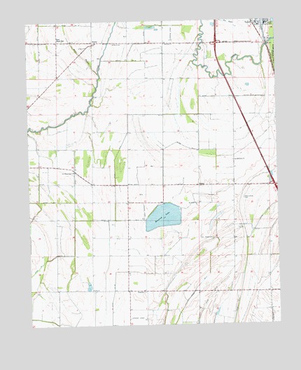
Heafer, AR USGS Topographic Map
Click on map above to begin viewing in our Map Viewer.

This topographic map contains these locations and features:
Feature Name Type Latitude Longitude GNIS ID View Map
Abston Wynne School (historical)SchoolN35.3129°W90.3520°59235View Map
Bell School (historical)SchoolN35.2868°W90.3251°59237View Map
Benwood LakeLakeN35.2946°W90.3076°74654View Map
Billow CemeteryCemeteryN35.3027°W90.3182°59239View Map
BookerPopulated PlaceN35.3073°W90.2895°56935View Map
Booker CemeteryCemeteryN35.2992°W90.2909°70022View Map
Booker School (historical)SchoolN35.3070°W90.2893°70228View Map
Brown CemeteryCemeteryN35.2854°W90.2829°46996View Map
Butler Church (historical)ChurchN35.3001°W90.3257°59238View Map
Carruth School (historical)SchoolN35.2631°W90.2709°59244View Map
Cruse CemeteryCemeteryN35.2896°W90.2682°48238View Map
Deer BayouStreamN35.3537°W90.3387°48452View Map
Ditch Number 1CanalN35.3212°W90.3068°82018View Map
Ditch Number 10CanalN35.3590°W90.3262°82035View Map
Ditch Number 11CanalN35.3734°W90.3112°82051View Map
Ditch Number 11CanalN35.2665°W90.2901°82054View Map
Ditch Number 2CanalN35.2934°W90.3307°82132View Map
Ditch Number 21CanalN35.3612°W90.3684°82156View Map
Ditch Number 32CanalN35.2601°W90.3340°82221View Map
Ditch Number 4CanalN35.2504°W90.2540°82250View Map
Ditch Number 6CanalN35.3365°W90.3057°82334View Map
Ditch Number 7CanalN35.3040°W90.3520°82367View Map
Ditch Number 8CanalN35.3104°W90.3698°82391View Map
East Black OakLocaleN35.3670°W90.3595°48749View Map
Galilee ChurchChurchN35.2648°W90.3437°49311View Map
HeaferPopulated PlaceN35.3665°W90.3398°49975View Map
Heafer East Black Oak Volunteer Fire DepartmentBuildingN35.3664°W90.3584°2116551View Map
Interchange 17CrossingN35.3070°W90.2515°59039View Map
Interchange 21CrossingN35.3656°W90.2795°59040View Map
Lencross Church (historical)ChurchN35.3404°W90.3743°59236View Map
Macedonia ChurchChurchN35.3656°W90.3057°51578View Map
Mount Vernon ChurchChurchN35.2998°W90.2907°52427View Map
New Bethel Church (historical)ChurchN35.3293°W90.2987°59240View Map
New Bethlehem ChurchChurchN35.3176°W90.2720°52632View Map
New Bethlehem School (historical)SchoolN35.3359°W90.2709°59242View Map
New Mount Pisgah ChurchChurchN35.3131°W90.3520°77833View Map
Patterson School (historical)SchoolN35.3654°W90.3057°59241View Map
Philadelphia ChurchChurchN35.2637°W90.3170°53324View Map
Saint Pauls CemeteryCemeteryN35.3660°W90.3321°54452View Map
Saint Pauls ChurchChurchN35.3645°W90.3451°54458View Map
Township of WappanoccaCivilN35.3080°W90.2596°68755View Map
Turrell Post OfficePost OfficeN35.3739°W90.2571°2773503View Map
Turrell Volunteer Fire DepartmentBuildingN35.3728°W90.2584°2117231View Map
United States Fish and Wildlife Wapanocca National Wildlife Refuge Park SecurityBuildingN35.3672°W90.2529°2118566View Map
Walnut Grove CemeteryCemeteryN35.3020°W90.2671°56000View Map
Walnut Grove Church (historical)ChurchN35.3015°W90.2670°59243View Map

Note: Coordinates in the location and feature list above are referenced to NAD83 datum.


Copyright (C) 2008-2024 Ryan Niemi / Sunset Dynamics ... All Rights Reserved