TopoQuest Logo
Do you find TopoQuest useful?
Help keep TopoQuest running and adding new maps/features by donating!
Bitcoin:  19c7KJd3qBynnjoSw5npx9KScwjBe4ifkT
Litecoin:  LXs6TkuXGGXo1vDsWCkWVdjQX94eUKd6ui
Home View Maps Find Maps Find Places Resources & Links


Jerusalem, Georgia Topographic Map

USGS Map Title: Jerusalem, GA
USGS Map MRC: 30081H7
DRG (GeoTIFF) Download: o30081h7.tif


Neighboring USGS Topographic Map Quads:


  Boons Lake, GA  
31081A8
 

  Tarboro, GA  
31081A7
 

  Waverly, GA  
31081A6
 

  Burnt Fort, GA  
30081H8
 

  Jerusalem, GA  
30081H7
 

  Woodbine, GA  
30081H6
 

  Boulogne, FL  
30081G8
 

  Kings Ferry, FL  
30081G7
 

  Kingsland, GA  
30081G6


Map MRC Location:

N31°
W82°
N31°
W81°
H8 H7 H6 H5 H4 H3 H2 H1
G8 G7 G6 G5 G4 G3 G2 G1
F8 F7 F6 F5 F4 F3 F2 F1
E8 E7 E6 E5 E4 E3 E2 E1
D8 D7 D6 D5 D4 D3 D2 D1
C8 C7 C6 C5 C4 C3 C2 C1
B8 B7 B6 B5 B4 B3 B2 B1
A8 A7 A6 A5 A4 A3 A2 A1
N30°
W82°
N30°
W81°

Jerusalem, GA USGS 1:24K Topographic Map Preview:
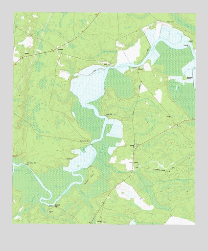
Jerusalem, GA USGS Topographic Map
Click on map above to begin viewing in our Map Viewer.

This topographic map contains these locations and features:
Feature Name Type Latitude Longitude GNIS ID View Map
Armstrong CreekStreamN30.9216°W81.8223°310621View Map
Baileys Mill CemeteryCemeteryN30.9224°W81.8221°1671303View Map
Bullhead BluffPopulated PlaceN30.8855°W81.8457°354909View Map
Bullhead CreekStreamN30.8988°W81.8282°312025View Map
Clarks BluffPopulated PlaceN30.9397°W81.8115°331408View Map
HazlehurstPopulated PlaceN30.9136°W81.8384°331942View Map
Hells GateChannelN30.9072°W81.8732°356252View Map
HopewellPopulated PlaceN30.9833°W81.7509°332023View Map
Hopewell PointCapeN30.9808°W81.7543°315668View Map
Independent ChurchChurchN30.8769°W81.8132°315883View Map
Ivanhoe Plantation (historical)LocaleN30.9705°W81.8134°1671366View Map
JeffersonPopulated PlaceN30.9666°W81.7901°332093View Map
JerusalemPopulated PlaceN30.9783°W81.8457°332096View Map
Jerusalem Number One Baptist ChurchChurchN30.9720°W81.8442°1671367View Map
Jim Baileys MillLocaleN30.9238°W81.8221°316109View Map
John Baileys MillLocaleN30.9108°W81.8659°316129View Map
Long BluffCliffN30.9066°W81.8609°1671379View Map
Long Bluff Plantation (historical)LocaleN30.9072°W81.8609°1671380View Map
Manning CemeteryCemeteryN30.8824°W81.8501°1671384View Map
Maryfield Plantation (historical)LocaleN30.9816°W81.8032°1671388View Map
MidriverPopulated PlaceN30.9758°W81.8673°332383View Map
Monfort IslandIslandN30.9016°W81.8223°318389View Map
Monkey IslandIslandN30.9608°W81.7543°318393View Map
New Hope ChurchChurchN30.9213°W81.7915°319359View Map
Owens FerryLocaleN30.9697°W81.8076°320131View Map
Refuge CampLocaleN30.9941°W81.7701°321488View Map
Refuge Plantation (historical)LocaleN30.9941°W81.7723°1671410View Map
Riley CreekStreamN30.8911°W81.8546°321610View Map
Rose CreekStreamN30.9244°W81.8148°321900View Map
Sandwash CreekSwampN30.8800°W81.8496°322456View Map
ScarletPopulated PlaceN30.9341°W81.7637°332989View Map
TompkinsPopulated PlaceN30.9116°W81.7926°333244View Map
Tompkins CemeteryCemeteryN30.9216°W81.7907°324220View Map
Westlight ChurchChurchN30.9391°W81.7668°325090View Map

Note: Coordinates in the location and feature list above are referenced to NAD83 datum.


Copyright (C) 2008-2025 Ryan Niemi / Sunset Dynamics ... All Rights Reserved