TopoQuest Logo
Do you find TopoQuest useful?
Help keep TopoQuest running and adding new maps/features by donating!
Bitcoin:  19c7KJd3qBynnjoSw5npx9KScwjBe4ifkT
Litecoin:  LXs6TkuXGGXo1vDsWCkWVdjQX94eUKd6ui
Home View Maps Find Maps Find Places Resources & Links


Kings Ferry, Florida Topographic Map

USGS Map Title: Kings Ferry, FL
USGS Map MRC: 30081G7
DRG (GeoTIFF) Download: o30081g7.tif


Neighboring USGS Topographic Map Quads:


  Burnt Fort, GA  
30081H8
 

  Jerusalem, GA  
30081H7
 

  Woodbine, GA  
30081H6
 

  Boulogne, FL  
30081G8
 

  Kings Ferry, FL  
30081G7
 

  Kingsland, GA  
30081G6
 

  Hilliard, FL  
30081F8
 

  Hilliard NE, FL  
30081F7
 

  Gross, FL  
30081F6


Map MRC Location:

N31°
W82°
N31°
W81°
H8 H7 H6 H5 H4 H3 H2 H1
G8 G7 G6 G5 G4 G3 G2 G1
F8 F7 F6 F5 F4 F3 F2 F1
E8 E7 E6 E5 E4 E3 E2 E1
D8 D7 D6 D5 D4 D3 D2 D1
C8 C7 C6 C5 C4 C3 C2 C1
B8 B7 B6 B5 B4 B3 B2 B1
A8 A7 A6 A5 A4 A3 A2 A1
N30°
W82°
N30°
W81°

Kings Ferry, FL USGS 1:24K Topographic Map Preview:
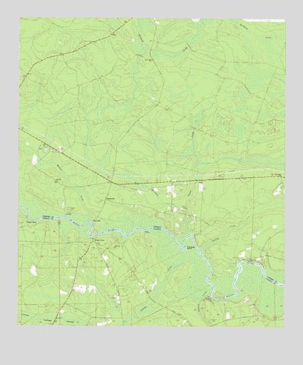
Kings Ferry, FL USGS Topographic Map
Click on map above to begin viewing in our Map Viewer.

This topographic map contains these locations and features:
Feature Name Type Latitude Longitude GNIS ID View Map
Allens Mill (historical)LocaleN30.7872°W81.7921°334129View Map
Blood LandingLocaleN30.7891°W81.8157°295138View Map
Brickyard CemeteryCemeteryN30.7516°W81.7826°279379View Map
Brickyard LandingLocaleN30.7619°W81.7834°295150View Map
Cabbage BendBendN30.7822°W81.7954°279783View Map
Cabbage CreekStreamN30.7811°W81.7982°279786View Map
Camden County Fire - Rescue Station 15BuildingN30.8095°W81.8012°2603749View Map
Catfish CreekStreamN30.7800°W81.7879°312428View Map
City of KingslandCivilN30.8187°W81.7870°2404833View Map
Clark Bluff CemeteryCemeteryN30.7775°W81.7665°355169View Map
Clarks BluffPopulated PlaceN30.7780°W81.7657°1671322View Map
Cossiers CreekStreamN30.7647°W81.7834°280873View Map
Flea HillPopulated PlaceN30.7930°W81.8393°331729View Map
Germantown (historical)Populated PlaceN30.7897°W81.8043°1671348View Map
Germantown School (historical)SchoolN30.8255°W81.8743°334131View Map
Green CemeteryCemeteryN30.8661°W81.8121°1671351View Map
GreenvillePopulated PlaceN30.8016°W81.8332°331868View Map
Haddock CemeteryCemeteryN30.7608°W81.8293°283581View Map
Haddock CemeteryCemeteryN30.7941°W81.8284°307159View Map
Horsepen CreekStreamN30.7888°W81.7943°315712View Map
Kings FerryPopulated PlaceN30.7852°W81.8390°285120View Map
Kings Ferry (historical)CrossingN30.7866°W81.8390°1671370View Map
Kingsland DivisionCivilN30.8353°W81.7750°1936345View Map
Mallets CemeteryCemeteryN30.7977°W81.8504°317644View Map
Mallets CreekStreamN30.7958°W81.8401°317645View Map
Mallets LandingLocaleN30.7958°W81.8526°332309View Map
Merrles BluffCliffN30.7863°W81.7915°1671391View Map
Mount Olive ChurchChurchN30.7825°W81.8293°287277View Map
Mount Zion Church (historical)ChurchN30.8736°W81.8665°334132View Map
Oak Hill CemeteryCemeteryN30.8086°W81.8573°1671400View Map
Oak Hill ChurchChurchN30.8088°W81.8571°319828View Map
Orange BluffCliffN30.7925°W81.8682°288183View Map
Ruhamah ChurchChurchN30.8119°W81.7518°321993View Map
SilcoPopulated PlaceN30.8683°W81.8309°333050View Map
Spring Hill ChurchChurchN30.8580°W81.8109°323409View Map
Temple ChurchChurchN30.8091°W81.7882°323980View Map
Temple CreekStreamN30.7994°W81.7982°323984View Map
Zion Sisters Baptist ChurchChurchN30.8016°W81.8340°1671440View Map

Note: Coordinates in the location and feature list above are referenced to NAD83 datum.


Copyright (C) 2008-2025 Ryan Niemi / Sunset Dynamics ... All Rights Reserved