TopoQuest Logo
Do you find TopoQuest useful?
Help keep TopoQuest running and adding new maps/features by donating!
Bitcoin:  19c7KJd3qBynnjoSw5npx9KScwjBe4ifkT
Litecoin:  LXs6TkuXGGXo1vDsWCkWVdjQX94eUKd6ui
Home View Maps Find Maps Find Places Resources & Links


Burnt Fort, Georgia Topographic Map

USGS Map Title: Burnt Fort, GA
USGS Map MRC: 30081H8
DRG (GeoTIFF) Download: o30081h8.tif


Neighboring USGS Topographic Map Quads:


  Winokur, GA  
31082A1
 

  Boons Lake, GA  
31081A8
 

  Tarboro, GA  
31081A7
 

  Newell, GA  
30082H1
 

  Burnt Fort, GA  
30081H8
 

  Jerusalem, GA  
30081H7
 

  Folkston, GA  
30082G1
 

  Boulogne, FL  
30081G8
 

  Kings Ferry, FL  
30081G7


Map MRC Location:

N31°
W82°
N31°
W81°
H8 H7 H6 H5 H4 H3 H2 H1
G8 G7 G6 G5 G4 G3 G2 G1
F8 F7 F6 F5 F4 F3 F2 F1
E8 E7 E6 E5 E4 E3 E2 E1
D8 D7 D6 D5 D4 D3 D2 D1
C8 C7 C6 C5 C4 C3 C2 C1
B8 B7 B6 B5 B4 B3 B2 B1
A8 A7 A6 A5 A4 A3 A2 A1
N30°
W82°
N30°
W81°

Burnt Fort, GA USGS 1:24K Topographic Map Preview:
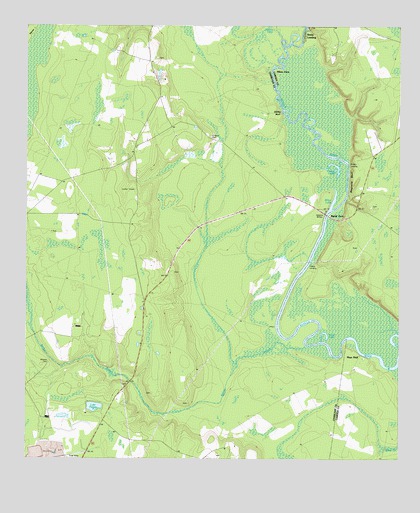
Burnt Fort, GA USGS Topographic Map
Click on map above to begin viewing in our Map Viewer.

This topographic map contains these locations and features:
Feature Name Type Latitude Longitude GNIS ID View Map
Allens FerryLocaleN30.9872°W81.9171°310465View Map
Antioch CemeteryCemeteryN30.9030°W81.9921°310551View Map
Antioch Church (historical)ChurchN30.9027°W81.9932°334133View Map
Baileys BranchStreamN30.9077°W81.9062°310726View Map
Big BaySwampN30.9821°W81.9987°311296View Map
Billys LakeLakeN30.9501°W81.8969°311438View Map
Burnt FortPopulated PlaceN30.9455°W81.8982°354913View Map
Burnt Fort CemeteryCemeteryN30.9480°W81.8843°1671312View Map
Burnt Fort ChurchChurchN30.9466°W81.8851°1671313View Map
Burnt Fort Ferry (historical)CrossingN30.9455°W81.8993°1671314View Map
Burnt Fort School (historical)SchoolN30.9366°W81.8887°334130View Map
Camp LakeLakeN30.9604°W81.8977°312234View Map
Clarks LandingLocaleN30.9302°W81.9054°331409View Map
Corinth CemeteryCemeteryN30.9911°W81.9562°357752View Map
Corinth Primitive Baptist ChurchChurchN30.9911°W81.9565°355308View Map
Godley LandingLocaleN30.9602°W81.8918°331834View Map
Gormans BluffCliffN30.9050°W81.8937°357764View Map
Hich BluffCliffN30.9813°W81.9168°357766View Map
Hopkins BridgeBridgeN30.9461°W81.8996°315670View Map
Lake PaxtonLakeN30.8903°W81.9767°320293View Map
Lowther CemeteryCemeteryN30.9291°W81.9504°357773View Map
Magnolia BluffCliffN30.9566°W81.8912°317602View Map
Mays BluffPopulated PlaceN30.9055°W81.8876°332341View Map
Mount Zion Church (historical)SchoolN30.9080°W81.9973°334136View Map
O'Berry CemeteryCemeteryN30.9683°W81.9384°319725View Map
Prescott (historical)Populated PlaceN30.9900°W81.9587°357786View Map
Prescott School (historical)SchoolN30.9652°W81.9634°334137View Map
Rains LandingPopulated PlaceN30.9975°W81.9068°332784View Map
Shirley BluffCliffN30.9752°W81.9143°322915View Map
The BasinBayN30.9827°W81.9171°357738View Map
Trout LakeLakeN30.9117°W81.8998°324336View Map

Note: Coordinates in the location and feature list above are referenced to NAD83 datum.


Copyright (C) 2008-2024 Ryan Niemi / Sunset Dynamics ... All Rights Reserved