TopoQuest Logo
Do you find TopoQuest useful?
Help keep TopoQuest running and adding new maps/features by donating!
Bitcoin:  19c7KJd3qBynnjoSw5npx9KScwjBe4ifkT
Litecoin:  LXs6TkuXGGXo1vDsWCkWVdjQX94eUKd6ui
Home View Maps Find Maps Find Places Resources & Links


Jonesville South, Louisiana Topographic Map

USGS Map Title: Jonesville South, LA
USGS Map MRC: 31091E7
DRG (GeoTIFF) Download: o31091e7.tif


Neighboring USGS Topographic Map Quads:


  Manifest, LA  
31091F8
 

  Jonesville North, LA  
31091F7
 

  Dunbarton, LA  
31091F6
 

  Walters, LA  
31091E8
 

  Jonesville South, LA  
31091E7
 

  Frogmore, LA  
31091E6
 

  Larto Lake North, LA  
31091D8
 

  Mayna, LA  
31091D7
 

  Monterey, LA  
31091D6


Map MRC Location:

N32°
W92°
N32°
W91°
H8 H7 H6 H5 H4 H3 H2 H1
G8 G7 G6 G5 G4 G3 G2 G1
F8 F7 F6 F5 F4 F3 F2 F1
E8 E7 E6 E5 E4 E3 E2 E1
D8 D7 D6 D5 D4 D3 D2 D1
C8 C7 C6 C5 C4 C3 C2 C1
B8 B7 B6 B5 B4 B3 B2 B1
A8 A7 A6 A5 A4 A3 A2 A1
N31°
W92°
N31°
W91°

Jonesville South, LA USGS 1:24K Topographic Map Preview:
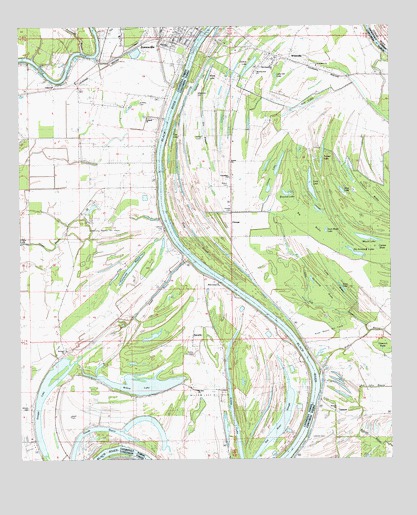
Jonesville South, LA USGS Topographic Map
Click on map above to begin viewing in our Map Viewer.

This topographic map contains these locations and features:
Feature Name Type Latitude Longitude GNIS ID View Map
Ackland ChurchChurchN31.5988°W91.8321°541594View Map
Aimwell ChurchChurchN31.5141°W91.7690°541590View Map
Barber CemeteryCemeteryN31.5304°W91.8168°541592View Map
Bethel ChurchChurchN31.5857°W91.8032°532975View Map
Big BrakeSwampN31.5643°W91.7737°533035View Map
Bill John BayouStreamN31.5080°W91.7610°533120View Map
Calhoun CemeteryCemeteryN31.5663°W91.8268°541593View Map
California BayouLakeN31.5539°W91.8392°533630View Map
California Bayou Oil FieldOilfieldN31.5666°W91.8460°541596View Map
Carr LakeLakeN31.5919°W91.8240°553903View Map
Carr Lake Oil FieldOilfieldN31.6085°W91.8473°546004View Map
Cauley LakeLakeN31.5851°W91.7876°553930View Map
Clear LakeLakeN31.5495°W91.7666°554014View Map
Cypress BrakeSwampN31.5624°W91.7546°541589View Map
De Armond LakeLakeN31.5596°W91.7618°554196View Map
Duck Roost LakeLakeN31.5663°W91.7718°554290View Map
Elmly CemeteryCemeteryN31.5521°W91.8251°554357View Map
Elmy Plantation (historical)LocaleN31.5521°W91.8273°546012View Map
Emiline LakeLakeN31.6133°W91.7976°554359View Map
Evangeline Baptist ChurchChurchN31.6135°W91.7740°558218View Map
Fourmile BayouStreamN31.6179°W91.8535°535067View Map
Friendship ChurchChurchN31.5818°W91.8043°535117View Map
Gin LakeLakeN31.6034°W91.7756°554532View Map
Gin SloughGutN31.5946°W91.8121°535234View Map
Glade BayouLakeN31.5045°W91.8553°535240View Map
Glade CemeteryCemeteryN31.5127°W91.8585°556629View Map
Glade LakeSwampN31.5158°W91.8211°557906View Map
Glade Oil FieldOilfieldN31.5232°W91.8648°546015View Map
Glade Plantation (historical)LocaleN31.5127°W91.8598°546016View Map
Glasscock BrakeSwampN31.5326°W91.7526°535246View Map
Grassy LakeLakeN31.5205°W91.8047°554598View Map
Griffin CemeteryCemeteryN31.5935°W91.8151°535425View Map
Harmon LakeLakeN31.6112°W91.8132°554660View Map
Hibbs Lake Oil FieldOilfieldN31.5543°W91.8654°546021View Map
Jones BayouGutN31.5488°W91.8285°558245View Map
Jonesville AirportAirportN31.6227°W91.8305°1632780View Map
Jonesville Junior High SchoolSchoolN31.6244°W91.8226°546026View Map
KMES-FM (Jonesville)TowerN31.5868°W91.7576°1633065View Map
LismorePopulated PlaceN31.5157°W91.7721°541128View Map
Lismore CemeteryCemeteryN31.5060°W91.7760°536473View Map
Little Gin LakeSwampN31.6114°W91.7881°555074View Map
Long BrakeSwampN31.5532°W91.7715°536680View Map
Long LakeLakeN31.5801°W91.7772°555144View Map
Long SloughLakeN31.5676°W91.8181°536714View Map
Mack LakeLakeN31.5640°W91.7593°555205View Map
Mayo LandingLocaleN31.5791°W91.8290°546035View Map
Morning Star ChurchChurchN31.6113°W91.7957°541587View Map
Moss Grove Baptist ChurchChurchN31.5510°W91.8082°558270View Map
Moss Grove CemeteryCemeteryN31.5513°W91.8087°546036View Map
Moss Grove Plantation CemeteryCemeteryN31.5466°W91.8037°546038View Map
Moss Grove Plantaton (historical)LocaleN31.5474°W91.8029°546037View Map
Mount Zion ChurchChurchN31.5202°W91.8157°541591View Map
Myers LakeLakeN31.6116°W91.8110°555451View Map
Normandy BrakeSwampN31.5481°W91.7743°537704View Map
North Willow Lake Oil FieldOilfieldN31.5463°W91.8293°546042View Map
Oak BayouGutN31.5443°W91.7740°537767View Map
Old Daughters ChurchChurchN31.6135°W91.7901°541586View Map
Old River SloughLakeN31.5100°W91.7876°537852View Map
OmegaPopulated PlaceN31.5718°W91.8035°558278View Map
Omega CemeteryCemeteryN31.5716°W91.8040°541588View Map
Omega Oil FieldOilfieldN31.5754°W91.8043°544659View Map
Omega School (historical)SchoolN31.5624°W91.8035°544675View Map
Parish Governing Authority District 7CivilN31.6225°W91.8177°1930181View Map
Parish Governing Authority District 8CivilN31.6226°W91.8364°1930229View Map
Ross Bayou Gas FieldOilfieldN31.5324°W91.7973°546051View Map
Ross Bayou Oil FieldOilfieldN31.5266°W91.7673°538731View Map
Round LakeLakeN31.5769°W91.7844°555848View Map
Saint Mary CemeteryCemeteryN31.6032°W91.8343°541595View Map
Saint Peter ChurchChurchN31.5318°W91.8593°555932View Map
SecurityPopulated PlaceN31.5343°W91.8165°539248View Map
Security Plantation (historical)LocaleN31.5349°W91.8168°546053View Map
Security Plantation CemeteryCemeteryN31.5324°W91.8073°546054View Map
Simpson BrakeSwampN31.5763°W91.7580°539390View Map
Snag LakeLakeN31.5772°W91.7661°556073View Map
Snaggy LakeLakeN31.5165°W91.8685°556075View Map
Snaggy Lake Volunteer Fire DepartmentBuildingN31.5019°W91.8686°2673073View Map
South Utility Oil FieldOilfieldN31.5780°W91.8460°546062View Map
Town of JonesvilleCivilN31.6239°W91.8299°2405922View Map
Tronsel LakeLakeN31.5860°W91.7734°556271View Map
Utility Baptist ChurchChurchN31.6082°W91.8629°558336View Map
Ward SevenCivilN31.6216°W91.8201°544978View Map
Ward SixCivilN31.6166°W91.8682°544977View Map
Whites CemeteryCemeteryN31.5154°W91.8721°540381View Map
WildsvillePopulated PlaceN31.6157°W91.7840°540409View Map
Wildsville Census Designated PlaceCensusN31.6220°W91.7889°2586720View Map
Wildsville Oil FieldOilfieldN31.5804°W91.7693°540410View Map
Wildsville Post OfficePost OfficeN31.6166°W91.7912°1632253View Map
Wilkerson CemeteryCemeteryN31.6054°W91.8148°540412View Map
Willow LakeLakeN31.5209°W91.8292°556434View Map
Willow Lake Oil FieldOilfieldN31.5224°W91.7868°540465View Map
Wilson CemeteryCemeteryN31.5796°W91.8040°540482View Map

Note: Coordinates in the location and feature list above are referenced to NAD83 datum.


Copyright (C) 2008-2025 Ryan Niemi / Sunset Dynamics ... All Rights Reserved