TopoQuest Logo
Do you find TopoQuest useful?
Help keep TopoQuest running and adding new maps/features by donating!
Bitcoin:  19c7KJd3qBynnjoSw5npx9KScwjBe4ifkT
Litecoin:  LXs6TkuXGGXo1vDsWCkWVdjQX94eUKd6ui
Home View Maps Find Maps Find Places Resources & Links


Monterey, Louisiana Topographic Map

USGS Map Title: Monterey, LA
USGS Map MRC: 31091D6
DRG (GeoTIFF) Download: o31091d6.tif


Neighboring USGS Topographic Map Quads:


  Jonesville South, LA  
31091E7
 

  Frogmore, LA  
31091E6
 

  Ferriday South, LA  
31091E5
 

  Mayna, LA  
31091D7
 

  Monterey, LA  
31091D6
 

  Deer Park, LA  
31091D5
 

  Acme, LA  
31091C7
 

  Slocum, LA  
31091C6
 

  Fairview, LA  
31091C5


Map MRC Location:

N32°
W92°
N32°
W91°
H8 H7 H6 H5 H4 H3 H2 H1
G8 G7 G6 G5 G4 G3 G2 G1
F8 F7 F6 F5 F4 F3 F2 F1
E8 E7 E6 E5 E4 E3 E2 E1
D8 D7 D6 D5 D4 D3 D2 D1
C8 C7 C6 C5 C4 C3 C2 C1
B8 B7 B6 B5 B4 B3 B2 B1
A8 A7 A6 A5 A4 A3 A2 A1
N31°
W92°
N31°
W91°

Monterey, LA USGS 1:24K Topographic Map Preview:
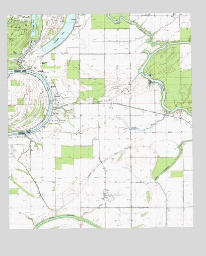
Monterey, LA USGS Topographic Map
Click on map above to begin viewing in our Map Viewer.

This topographic map contains these locations and features:
Feature Name Type Latitude Longitude GNIS ID View Map
Bayou Cross CocodrieStreamN31.4818°W91.6440°553443View Map
Big BayBayN31.4774°W91.6554°533019View Map
Central High School (historical)SchoolN31.4563°W91.7198°557933View Map
Church of ChristChurchN31.4424°W91.7185°541974View Map
Clayton LakeLakeN31.4774°W91.7441°554009View Map
Concordia ParishCivilN31.4458°W91.6401°558515View Map
Crane CemeteryCemeteryN31.4929°W91.7040°541982View Map
Cross CemeteryCemeteryN31.4352°W91.7251°541972View Map
Cross CemeteryCemeteryN31.4968°W91.7029°541981View Map
East Kincaid Bayou Oil FieldOilfieldN31.4560°W91.7351°546011View Map
First Baptist ChurchChurchN31.4668°W91.7262°541975View Map
Flat BayouStreamN31.3771°W91.7312°534982View Map
Ford CemeteryCemeteryN31.4727°W91.7398°541979View Map
Horse Shoe IslandIslandN31.4988°W91.7182°557907View Map
Kenyon BayouStreamN31.4982°W91.7335°536177View Map
Lismore Landing Oil FieldOilfieldN31.4938°W91.7460°536474View Map
Little BayBayN31.4643°W91.6557°536477View Map
Long LakeLakeN31.4366°W91.7423°555154View Map
Luckett CemeteryCemeteryN31.4732°W91.7440°541980View Map
MontereyPopulated PlaceN31.4499°W91.7182°558269View Map
Monterey Census Designated PlaceCensusN31.4436°W91.7191°2586696View Map
Monterey ChurchChurchN31.4688°W91.7365°541978View Map
Monterey Fire Protection District 1BuildingN31.4589°W91.7224°2672802View Map
Monterey High SchoolSchoolN31.4579°W91.7204°1629834View Map
Monterey Post OfficePost OfficeN31.4504°W91.7178°1632240View Map
North Bayou Cocodrie Oil FieldOilfieldN31.3902°W91.6829°537712View Map
North Whites Bayou Oil FieldOilfieldN31.4568°W91.6765°541990View Map
Northeast Bayou Cocodrie Oil FieldOilfieldN31.3835°W91.6540°544656View Map
Northwest Bayou Cocadrie Oil FieldOilfieldN31.4102°W91.6907°544658View Map
Parhams Volunteer Fire DepartmentBuildingN31.4658°W91.7440°2673074View Map
Plouden BayouStreamN31.4652°W91.6610°555689View Map
Quinn Bayou Oil FieldOilfieldN31.4091°W91.6568°538455View Map
Rice CemeteryCemeteryN31.4638°W91.7254°538579View Map
Scott CemeteryCemeteryN31.4752°W91.7271°539231View Map
Smith CemeteryCemeteryN31.4691°W91.7323°541977View Map
South Monterey Oil FieldOilfieldN31.4377°W91.7148°541973View Map
South Quinn Bayou Oil FieldOilfieldN31.4016°W91.6576°544677View Map
Temple Church of MontereyChurchN31.4716°W91.7273°541976View Map
Wallace BayouStreamN31.3805°W91.7021°540205View Map
Wallace BayouStreamN31.4829°W91.6271°540206View Map
Whites BayouStreamN31.4418°W91.6410°540380View Map
Workinger BayouStreamN31.4685°W91.7393°558347View Map
Wyches BayouStreamN31.4027°W91.6512°540554View Map
Wyches Bayou Oil FieldOilfieldN31.4027°W91.7293°544703View Map

Note: Coordinates in the location and feature list above are referenced to NAD83 datum.


Copyright (C) 2008-2025 Ryan Niemi / Sunset Dynamics ... All Rights Reserved