TopoQuest Logo
Do you find TopoQuest useful?
Help keep TopoQuest running and adding new maps/features by donating!
Bitcoin:  19c7KJd3qBynnjoSw5npx9KScwjBe4ifkT
Litecoin:  LXs6TkuXGGXo1vDsWCkWVdjQX94eUKd6ui
Home View Maps Find Maps Find Places Resources & Links


Balsam Lake, Wisconsin Topographic Map

USGS Map Title: Balsam Lake, WI
USGS Map MRC: 45092D4
DRG (GeoTIFF) Download: o45092d4.tif


Neighboring USGS Topographic Map Quads:


  Milltown, WI  
45092E5
 

  Luck, WI  
45092E4
 

  Big Round Lake, WI  
45092E3
 

  Centuria, WI  
45092D5
 

  Balsam Lake, WI  
45092D4
 

  Range, WI  
45092D3
 

  Nye, WI  
45092C5
 

  Wapogasset Lake, WI  
45092C4
 

  Amery, WI  
45092C3


Map MRC Location:

N46°
W93°
N46°
W92°
H8 H7 H6 H5 H4 H3 H2 H1
G8 G7 G6 G5 G4 G3 G2 G1
F8 F7 F6 F5 F4 F3 F2 F1
E8 E7 E6 E5 E4 E3 E2 E1
D8 D7 D6 D5 D4 D3 D2 D1
C8 C7 C6 C5 C4 C3 C2 C1
B8 B7 B6 B5 B4 B3 B2 B1
A8 A7 A6 A5 A4 A3 A2 A1
N45°
W93°
N45°
W92°

Balsam Lake, WI USGS 1:24K Topographic Map Preview:
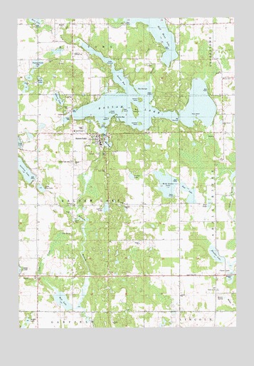
Balsam Lake, WI USGS Topographic Map
Click on map above to begin viewing in our Map Viewer.

This topographic map contains these locations and features:
Feature Name Type Latitude Longitude GNIS ID View Map
Apple River CemeteryCemeteryN45.3963°W92.3975°1560910View Map
Badger LakeLakeN45.3781°W92.4952°1561070View Map
Balsam ChurchChurchN45.3900°W92.3877°1561138View Map
Balsam LakeLakeN45.4654°W92.4273°1561140View Map
Balsam LakePopulated PlaceN45.4522°W92.4546°1561143View Map
Balsam Lake CemeteryCemeteryN45.4422°W92.4694°1561144View Map
Balsam Lake Police DepartmentBuildingN45.4498°W92.4527°2759579View Map
Balsam Lake Volunteer Fire DepartmentBuildingN45.4506°W92.4678°2696742View Map
Bear IslandIslandN45.4627°W92.4399°1561374View Map
Big IslandIslandN45.4633°W92.4333°1561736View Map
Big NarrowsGapN45.4591°W92.4074°1561752View Map
Boston BayBayN45.4744°W92.4405°1562087View Map
Brusher LakeLakeN45.4041°W92.3869°1562309View Map
Camp NeibelLocaleN45.4694°W92.3905°1831800View Map
Carlson IslandIslandN45.4669°W92.4302°1562720View Map
Cedar IslandIslandN45.4622°W92.4474°1562847View Map
Clover LakeLakeN45.3968°W92.3783°1563204View Map
Deer Lake School (historical)SchoolN45.3958°W92.4963°1831804View Map
East Balsam ChurchChurchN45.4572°W92.3816°1564272View Map
East Balsam School (historical)SchoolN45.4569°W92.3824°1831805View Map
East LakeLakeN45.4265°W92.4024°1564344View Map
East LakeLakeN45.4748°W92.4871°1564345View Map
Elkins LakeLakeN45.4675°W92.4769°1564533View Map
First IslandIslandN45.4577°W92.4508°1564968View Map
Goose Lake School (historical)SchoolN45.4252°W92.4121°1831814View Map
Half Moon LakeLakeN45.4946°W92.4205°1565974View Map
Harder CreekStreamN45.4747°W92.4241°1566063View Map
Laurel LakeLakeN45.4592°W92.4728°2761276View Map
Little Bass LakeLakeN45.4315°W92.4871°1568175View Map
Little NarrowsChannelN45.4811°W92.4455°1568333View Map
Loveless LakeLakeN45.4394°W92.4973°1568707View Map
Lower Balsam Lake DamDamN45.4483°W92.4502°1791706View Map
LykensPopulated PlaceN45.4244°W92.4691°1577712View Map
Lykens LakeLakeN45.4232°W92.4499°1568833View Map
Maple Grove School (historical)SchoolN45.4252°W92.4891°1831826View Map
Markee SpringSpringN45.3869°W92.3819°1569050View Map
Mill PondLakeN45.4496°W92.4485°1569487View Map
Mud LakeLakeN45.3862°W92.4753°1569952View Map
Mud LakeLakeN45.4249°W92.3904°1569953View Map
Otter CreekStreamN45.4955°W92.4733°1570897View Map
Paradise IslandIslandN45.4575°W92.4302°1571020View Map
Parker LakeLakeN45.4362°W92.4350°1571052View Map
Pine Grove School (historical)SchoolN45.4866°W92.4680°1831835View Map
Pine IslandIslandN45.4597°W92.4483°1571473View Map
Polk CountyCivilN45.4614°W92.4414°1581108View Map
Polk County CourthouseBuildingN45.4544°W92.4677°1831839View Map
Polk County JailBuildingN45.4530°W92.4720°2759840View Map
Polk County Sheriff's OfficeBuildingN45.4525°W92.4715°2759839View Map
Raskin BayBayN45.4594°W92.4430°1572084View Map
Rice CreekStreamN45.4900°W92.4627°1572248View Map
Rock IslandIslandN45.4611°W92.4005°1572452View Map
Romeo AirstripAirportN45.4585°W92.3783°2444136View Map
Shiloh School (historical)SchoolN45.3955°W92.4071°1831847View Map
The StumpsBayN45.4708°W92.4277°1575343View Map
Toby CreekStreamN45.3827°W92.4691°1575477View Map
Toby SpringSpringN45.4133°W92.4755°1575478View Map
Town of Balsam LakeCivilN45.4221°W92.4698°1582746View Map
Twenty-Ninth LakeLakeN45.4818°W92.4887°1575763View Map
Union CemeteryCemeteryN45.4753°W92.3774°1575894View Map
Unity Elementary SchoolSchoolN45.4851°W92.4655°2713234View Map
Unity High SchoolSchoolN45.4851°W92.4656°1575927View Map
Unity Middle SchoolSchoolN45.4852°W92.4656°2713187View Map
Upper Balsam Lake WP92 DamDamN45.4500°W92.4502°1793491View Map
Village of Balsam LakeCivilN45.4584°W92.4529°1582745View Map
Wild Goose LakeLakeN45.4329°W92.4151°1576729View Map

Note: Coordinates in the location and feature list above are referenced to NAD83 datum.


Copyright (C) 2008-2025 Ryan Niemi / Sunset Dynamics ... All Rights Reserved