TopoQuest Logo
Do you find TopoQuest useful?
Help keep TopoQuest running and adding new maps/features by donating!
Bitcoin:  19c7KJd3qBynnjoSw5npx9KScwjBe4ifkT
Litecoin:  LXs6TkuXGGXo1vDsWCkWVdjQX94eUKd6ui
Home View Maps Find Maps Find Places Resources & Links


Juniper Beach, Washington Topographic Map

USGS Map Title: Juniper Beach, WA
USGS Map MRC: 48122B4
DRG (GeoTIFF) Download: o48122b4.tif


Neighboring USGS Topographic Map Quads:


  Crescent Harbor, WA  
48122C5
 

  Utsalady, WA  
48122C4
 

  Conway, WA  
48122C3
 

  Camano, WA  
48122B5
 

  Juniper Beach, WA  
48122B4
 

  Stanwood, WA  
48122B3
 

  Freeland, WA  
48122A5
 

  Langley, WA  
48122A4
 

  Tulalip, WA  
48122A3


Map MRC Location:

N49°
W123°
N49°
W122°
H8 H7 H6 H5 H4 H3 H2 H1
G8 G7 G6 G5 G4 G3 G2 G1
F8 F7 F6 F5 F4 F3 F2 F1
E8 E7 E6 E5 E4 E3 E2 E1
D8 D7 D6 D5 D4 D3 D2 D1
C8 C7 C6 C5 C4 C3 C2 C1
B8 B7 B6 B5 B4 B3 B2 B1
A8 A7 A6 A5 A4 A3 A2 A1
N48°
W123°
N48°
W122°

Juniper Beach, WA USGS 1:24K Topographic Map Preview:
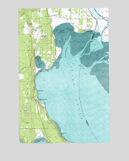
Juniper Beach, WA USGS Topographic Map
Click on map above to begin viewing in our Map Viewer.

This topographic map contains these locations and features:
Feature Name Type Latitude Longitude GNIS ID View Map
Barnum PointCapeN48.1934°W122.4621°1503186View Map
Calvary ChapelChurchN48.2133°W122.4771°2608443View Map
Camaloch Golf CourseLocaleN48.2237°W122.4718°2608378View Map
Camano Census Designated PlaceCensusN48.1707°W122.4650°2407940View Map
Camano Country ClubLocaleN48.1645°W122.4732°1503723View Map
Camano Island DivisionCivilN48.1707°W122.4650°1939463View Map
Camano Island Fire and Rescue AdministrationBuildingN48.2402°W122.4564°2767928View Map
Camano Island State ParkParkN48.1287°W122.4996°1503726View Map
Camano Lutheran Child Care CenterSchoolN48.2419°W122.4386°2606238View Map
Camano Luthern ChurchChurchN48.2416°W122.4388°2608741View Map
Camano Pioneer CemeteryCemeteryN48.2432°W122.4521°1503725View Map
Cavelero BeachLocaleN48.1732°W122.4757°1513079View Map
Christian Family Center of Camano IslandChurchN48.2393°W122.4059°2609346View Map
Cranberry LakeLakeN48.1437°W122.4921°1504249View Map
Davis SloughGutN48.2426°W122.3949°1504348View Map
Driftwood ShoresPopulated PlaceN48.1923°W122.4732°1510919View Map
Elger Bay Elementary SchoolSchoolN48.1452°W122.4684°2518517View Map
Island Baptist ChurchChurchN48.2271°W122.4731°2609347View Map
Island County Fire District 1 Camano Island Fire and Rescue Station 2 Country ClubBuildingN48.1628°W122.4780°2606036View Map
Island County Fire Protection District 1 Camano Island Fire and Rescue Station 3 Terrys CornerBuildingN48.2431°W122.4549°2606037View Map
Island County Sheriff Camano IslandBuildingN48.2137°W122.4783°2721984View Map
Juniper BeachPopulated PlaceN48.2309°W122.4071°1511062View Map
Kristoferson CreekStreamN48.2058°W122.4759°2706280View Map
Kristoferson LakeReservoirN48.2292°W122.4771°1513460View Map
Kristofferson Lake DamDamN48.2282°W122.4779°1532114View Map
Lindsay LakeLakeN48.2348°W122.4865°1506175View Map
Livingston BayBayN48.2260°W122.4396°1506241View Map
Livingston Bay Airport (historical)AirportN48.2365°W122.4524°1533982View Map
Lona BeachPopulated PlaceN48.2043°W122.4465°1513154View Map
Lost LakeLakeN48.1551°W122.4901°1506330View Map
Mountain View BeachLocaleN48.1334°W122.4449°1506839View Map
New UtsaladdyPopulated PlaceN48.2423°W122.4713°1514792View Map
Orchards NurseryBuildingN48.2414°W122.3761°2704395View Map
River of Life Community ChurchChurchN48.2421°W122.4572°2609348View Map
Saint Aidans Episcopal ChurchChurchN48.2389°W122.4108°2609349View Map
Smith LakeLakeN48.2265°W122.4663°1508437View Map
South Camano SubstationLocaleN48.1621°W122.4779°2606840View Map
South PassChannelN48.2323°W122.3815°1508559View Map
Stillaguamish RiverStreamN48.2384°W122.3771°1508743View Map
Sundins BeachLocaleN48.2318°W122.4240°1513218View Map
Sunrise PointLocaleN48.2020°W122.4513°1508836View Map
Terry's Corner Park and RideLocaleN48.2422°W122.4545°2608146View Map
Terrys CornerPopulated PlaceN48.2445°W122.4560°1511365View Map
The Church of Jesus Christ of Latter Day SaintsChurchN48.2388°W122.4098°2609350View Map
Triangle CoveBayN48.1996°W122.4724°1509079View Map
Utsalady Elementary SchoolSchoolN48.2347°W122.4684°2518516View Map
Utsalady Elementary SchoolSchoolN48.2331°W122.4719°2462509View Map
West PassChannelN48.2465°W122.3904°1509417View Map

Note: Coordinates in the location and feature list above are referenced to NAD83 datum.


Copyright (C) 2008-2025 Ryan Niemi / Sunset Dynamics ... All Rights Reserved