TopoQuest Logo
Do you find TopoQuest useful?
Help keep TopoQuest running and adding new maps/features by donating!
Bitcoin:  19c7KJd3qBynnjoSw5npx9KScwjBe4ifkT
Litecoin:  LXs6TkuXGGXo1vDsWCkWVdjQX94eUKd6ui
Home View Maps Find Maps Find Places Resources & Links


Langley, Washington Topographic Map

USGS Map Title: Langley, WA
USGS Map MRC: 48122A4
DRG (GeoTIFF) Download: o48122a4.tif


Neighboring USGS Topographic Map Quads:


  Camano, WA  
48122B5
 

  Juniper Beach, WA  
48122B4
 

  Stanwood, WA  
48122B3
 

  Freeland, WA  
48122A5
 

  Langley, WA  
48122A4
 

  Tulalip, WA  
48122A3
 

  Hansville, WA  
47122H5
 

  Maxwelton, WA  
47122H4
 

  Mukilteo, WA  
47122H3


Map MRC Location:

N49°
W123°
N49°
W122°
H8 H7 H6 H5 H4 H3 H2 H1
G8 G7 G6 G5 G4 G3 G2 G1
F8 F7 F6 F5 F4 F3 F2 F1
E8 E7 E6 E5 E4 E3 E2 E1
D8 D7 D6 D5 D4 D3 D2 D1
C8 C7 C6 C5 C4 C3 C2 C1
B8 B7 B6 B5 B4 B3 B2 B1
A8 A7 A6 A5 A4 A3 A2 A1
N48°
W123°
N48°
W122°

Langley, WA USGS 1:24K Topographic Map Preview:
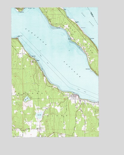
Langley, WA USGS Topographic Map
Click on map above to begin viewing in our Map Viewer.

This topographic map contains these locations and features:
Feature Name Type Latitude Longitude GNIS ID View Map
Bay ViewPopulated PlaceN48.0076°W122.4613°1530802View Map
Bayview Alternative High SchoolSchoolN48.0063°W122.4613°2518429View Map
Bayview Park and RideLocaleN48.0037°W122.4616°2608160View Map
Bells BeachPopulated PlaceN48.0768°W122.4690°1503295View Map
BretlandPopulated PlaceN48.1220°W122.4260°1510891View Map
Camp DianaPopulated PlaceN48.1059°W122.4310°1512060View Map
City of LangleyCivilN48.0338°W122.4084°2411623View Map
East PointCapeN48.0965°W122.4921°1504651View Map
Elger BayBayN48.1248°W122.4717°1504705View Map
First Baptist Church of South WhidbeyChurchN48.0091°W122.4918°2608585View Map
House of Prayer ChurchChurchN48.0031°W122.4410°2608845View Map
Island Christian AcademySchoolN48.0148°W122.4087°2606403View Map
Island Christian AcademySchoolN48.0148°W122.4087°2518440View Map
Island County Fire District 1 Camano Island Fire and Rescue Station 5 MabanaBuildingN48.0937°W122.4101°2619773View Map
Island County Fire District 3 Langley Fire HallBuildingN48.0397°W122.4076°2619408View Map
Island County Fire Protection District 3 South Whidbey Fire / EMS Langley Station 34BuildingN48.0329°W122.4015°2767932View Map
Island County Fire Protection District 3 South Whidbey Fire / EMS Saratoga Station 35BuildingN48.0664°W122.4620°2643619View Map
Lake GossLakeN48.0367°W122.4797°1505201View Map
LangleyPopulated PlaceN48.0401°W122.4063°1512376View Map
Langley Christian and Missionary Alliance ChurchChurchN48.0370°W122.4053°2608958View Map
Langley Christian and Missionary Alliance PreschoolSchoolN48.0371°W122.4053°2606481View Map
Langley City HallBuildingN48.0401°W122.4067°2610614View Map
Langley City Small Boat HarborLocaleN48.0386°W122.4031°2610309View Map
Langley LibraryBuildingN48.0401°W122.4065°2610178View Map
Langley Middle SchoolSchoolN48.0353°W122.4031°1514951View Map
Langley Police DepartmentBuildingN48.0401°W122.4067°2722078View Map
Langley Post OfficePost OfficeN48.0396°W122.4066°2606963View Map
Langley Sewage Treatment PlantLocaleN48.0303°W122.4212°2610686View Map
Langley United Methodist ChurchChurchN48.0389°W122.4098°2609586View Map
Langley Woodman CemeteryCemeteryN48.0276°W122.4076°2767968View Map
Lone LakeLakeN48.0211°W122.4618°1530986View Map
Lowell PointCapeN48.1207°W122.4896°1513155View Map
MabanaPopulated PlaceN48.0945°W122.4151°1511111View Map
Mabana ChapelChurchN48.0891°W122.4012°2608989View Map
Maple CoveBayN48.0318°W122.3759°1514793View Map
Pebble BeachPopulated PlaceN48.0665°W122.3874°1512553View Map
Port SusanBayN48.1132°W122.3915°1507576View Map
Saint Hubert Catholic ChurchChurchN48.0395°W122.4155°2609587View Map
Sandy PointCapeN48.0345°W122.3757°1508116View Map
SaratogaPopulated PlaceN48.0734°W122.4663°1512642View Map
South Whidbey Assembly of God ChurchChurchN48.0148°W122.4087°2609588View Map
South Whidbey Elementary SchoolSchoolN48.0141°W122.4114°1514953View Map
South Whidbey Generating StationLocaleN48.0307°W122.4276°2606864View Map
South Whidbey High SchoolSchoolN48.0054°W122.4099°1514950View Map
South Whidbey Intermediate SchoolSchoolN48.0143°W122.4112°1514952View Map
South Whidbey School District 206 OfficeSchoolN48.0343°W122.4034°2518478View Map
Sunny Shore AcresPopulated PlaceN48.1087°W122.4068°1513219View Map
The Church of Jesus Christ of Latter Day SaintsChurchN48.0134°W122.4089°2609589View Map
Tillicum BeachLocaleN48.1032°W122.3999°1509026View Map
Tyee BeachPopulated PlaceN48.0926°W122.3857°1512745View Map
Useless Bay Golf and Country ClubLocaleN48.0014°W122.4805°2608207View Map
Wheel Estates Mobile Home ParkPopulated PlaceN48.0295°W122.4489°2607322View Map
Whidbey Air ParkAirportN48.0200°W122.4373°1533814View Map
Whidbey General Emergency Medical Services SouthBuildingN48.0027°W122.4611°2643890View Map
Whidbey Island Academy Shared SchoolSchoolN48.0057°W122.4100°2518519View Map
Whidbey Island Center for the ArtsBuildingN48.0359°W122.4036°2608222View Map
Wood Landing Strip (historical)AirportN48.0590°W122.4618°1534163View Map

Note: Coordinates in the location and feature list above are referenced to NAD83 datum.


Copyright (C) 2008-2024 Ryan Niemi / Sunset Dynamics ... All Rights Reserved