TopoQuest Logo
Do you find TopoQuest useful?
Help keep TopoQuest running and adding new maps/features by donating!
Bitcoin:  19c7KJd3qBynnjoSw5npx9KScwjBe4ifkT
Litecoin:  LXs6TkuXGGXo1vDsWCkWVdjQX94eUKd6ui
Home View Maps Find Maps Find Places Resources & Links


Justice, North Carolina Topographic Map

USGS Map Title: Justice, NC
USGS Map MRC: 36078A2
DRG (GeoTIFF) Download: o36078a2.tif


Neighboring USGS Topographic Map Quads:


  Ingleside, NC  
36078B3
 

  Gold Sand, NC  
36078B2
 

  Centerville, NC  
36078B1
 

  Louisburg, NC  
36078A3
 

  Justice, NC  
36078A2
 

  Castalia, NC  
36078A1
 

  Bunn West, NC  
35078H3
 

  Bunn East, NC  
35078H2
 

  Spring Hope, NC  
35078H1


Map MRC Location:

N37°
W79°
N37°
W78°
H8 H7 H6 H5 H4 H3 H2 H1
G8 G7 G6 G5 G4 G3 G2 G1
F8 F7 F6 F5 F4 F3 F2 F1
E8 E7 E6 E5 E4 E3 E2 E1
D8 D7 D6 D5 D4 D3 D2 D1
C8 C7 C6 C5 C4 C3 C2 C1
B8 B7 B6 B5 B4 B3 B2 B1
A8 A7 A6 A5 A4 A3 A2 A1
N36°
W79°
N36°
W78°

Justice, NC USGS 1:24K Topographic Map Preview:
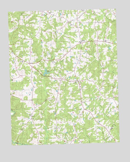
Justice, NC USGS Topographic Map
Click on map above to begin viewing in our Map Viewer.

This topographic map contains these locations and features:
Feature Name Type Latitude Longitude GNIS ID View Map
Best High SchoolSchoolN36.0943°W78.1669°1019104View Map
Cedar Rock Academy (historical)SchoolN36.0957°W78.1375°1008367View Map
Cedar Rock ChurchChurchN36.0952°W78.1380°1019586View Map
Duke Memorial ChurchChurchN36.0582°W78.1711°1020045View Map
Farrell BridgeBridgeN36.0024°W78.2433°1008371View Map
Gospel ChurchChurchN36.0518°W78.1680°985855View Map
Harris Pond Number ThreeReservoirN36.0468°W78.2264°999977View Map
Harris Pond Number Three DamDamN36.0468°W78.2264°999978View Map
Harris Pond Number TwoReservoirN36.0487°W78.2307°999980View Map
Harris Pond Number Two DamDamN36.0485°W78.2314°999979View Map
Hickory RockPopulated PlaceN36.1243°W78.2100°1020715View Map
Hickory Rock ChurchChurchN36.1232°W78.2017°1020716View Map
Hickory Rock School (historical)SchoolN36.1224°W78.2005°1008375View Map
Jacksons PondLakeN36.0646°W78.2086°1024059View Map
Jacksons Pond DamDamN36.0646°W78.2086°1024436View Map
JusticePopulated PlaceN36.0585°W78.1705°1021009View Map
Justice Rural Volunteer Fire StationBuildingN36.0533°W78.1683°2639178View Map
Lettuce Hollow ChurchChurchN36.0382°W78.1678°988367View Map
Long BranchStreamN36.0674°W78.2036°1024115View Map
MaplevillePopulated PlaceN36.0765°W78.2272°1024132View Map
MargaretPopulated PlaceN36.0249°W78.2261°989331View Map
Saints Delight ChurchChurchN36.1088°W78.1705°1022463View Map
Shiloh ChurchChurchN36.0293°W78.2258°1022607View Map
Stallings CrossroadsPopulated PlaceN36.0940°W78.1653°1024316View Map
Stallings Memorial ParkCemeteryN36.0571°W78.1719°995397View Map
Township of Cedar RockCivilN36.0928°W78.1420°1026693View Map
Township of Cypress CreekCivilN36.0045°W78.1943°1026694View Map
Walnut Grove ChurchChurchN36.0765°W78.1969°1023111View Map

Note: Coordinates in the location and feature list above are referenced to NAD83 datum.


Copyright (C) 2008-2025 Ryan Niemi / Sunset Dynamics ... All Rights Reserved