TopoQuest Logo
Do you find TopoQuest useful?
Help keep TopoQuest running and adding new maps/features by donating!
Bitcoin:  19c7KJd3qBynnjoSw5npx9KScwjBe4ifkT
Litecoin:  LXs6TkuXGGXo1vDsWCkWVdjQX94eUKd6ui
Home View Maps Find Maps Find Places Resources & Links


Bunn East, North Carolina Topographic Map

USGS Map Title: Bunn East, NC
USGS Map MRC: 35078H2
DRG (GeoTIFF) Download: o35078h2.tif


Neighboring USGS Topographic Map Quads:


  Louisburg, NC  
36078A3
 

  Justice, NC  
36078A2
 

  Castalia, NC  
36078A1
 

  Bunn West, NC  
35078H3
 

  Bunn East, NC  
35078H2
 

  Spring Hope, NC  
35078H1
 

  Zebulon, NC  
35078G3
 

  Middlesex, NC  
35078G2
 

  Bailey, NC  
35078G1


Map MRC Location:

N36°
W79°
N36°
W78°
H8 H7 H6 H5 H4 H3 H2 H1
G8 G7 G6 G5 G4 G3 G2 G1
F8 F7 F6 F5 F4 F3 F2 F1
E8 E7 E6 E5 E4 E3 E2 E1
D8 D7 D6 D5 D4 D3 D2 D1
C8 C7 C6 C5 C4 C3 C2 C1
B8 B7 B6 B5 B4 B3 B2 B1
A8 A7 A6 A5 A4 A3 A2 A1
N35°
W79°
N35°
W78°

Bunn East, NC USGS 1:24K Topographic Map Preview:
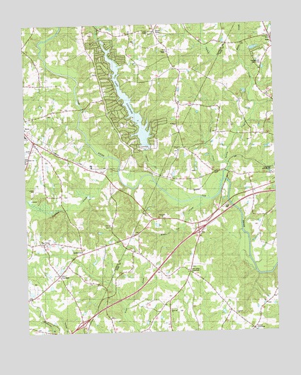
Bunn East, NC USGS Topographic Map
Click on map above to begin viewing in our Map Viewer.

This topographic map contains these locations and features:
Feature Name Type Latitude Longitude GNIS ID View Map
Anderson BridgeBridgeN35.9410°W78.2030°1008362View Map
Barbees PondReservoirN35.9985°W78.1330°999877View Map
Barbees Pond DamDamN35.9985°W78.1330°999876View Map
Bass PondReservoirN35.9602°W78.1297°999817View Map
Bass Pond DamDamN35.9602°W78.1297°999816View Map
Biddie Toe CreekStreamN35.9293°W78.1614°1023823View Map
Brantleys PondReservoirN35.9485°W78.1497°999784View Map
Brantleys Pond DamDamN35.9485°W78.1497°999785View Map
Bunn High SchoolSchoolN35.9557°W78.2492°1006575View Map
Bunn Police DepartmentBuildingN35.9545°W78.2465°2769669View Map
Bunn Rural Fire Association Station 1BuildingN35.9564°W78.2483°2639173View Map
Bunn Rural Fire Association Station 3BuildingN35.9694°W78.2104°2639110View Map
Coker CreekStreamN35.9440°W78.1489°1023915View Map
Creek School (historical)SchoolN35.9577°W78.1530°1951128View Map
Crooked CreekStreamN35.9396°W78.2030°1023932View Map
Crooked Creek AirportAirportN35.9318°W78.2440°2679122View Map
Cypress ChapelChurchN35.9888°W78.1775°983882View Map
Cypress CreekStreamN35.9360°W78.1844°1019894View Map
DaddysvillePopulated PlaceN35.9077°W78.2217°1019895View Map
Elizabeth ChurchChurchN35.8827°W78.1455°984689View Map
Franklin Correctional CenterBuildingN35.9463°W78.2492°2769852View Map
Frazier CrossroadsPopulated PlaceN35.8760°W78.1369°985375View Map
Gold Valley ChurchChurchN35.9002°W78.1689°1006897View Map
Gold Valley CrossroadsPopulated PlaceN35.8996°W78.1680°1006220View Map
Gold Valley School (historical)SchoolN35.9002°W78.1692°1951138View Map
Good News ChurchChurchN35.9215°W78.1817°985793View Map
Holly Grove ChurchChurchN35.9490°W78.1730°986953View Map
Jeffreys Siding Site (historical)LocaleN35.9377°W78.1789°1006893View Map
Jeffries PondReservoirN35.9485°W78.1580°999787View Map
Jeffries Pond DamDamN35.9485°W78.1580°999786View Map
Jones Hill ChurchChurchN35.9179°W78.2075°987755View Map
Justice Rural Volunteer Fire Association Station 2BuildingN35.9974°W78.1883°2639130View Map
Lake RoyaleReservoirN35.9704°W78.1989°1023546View Map
Lake Royale Census Designated PlaceCensusN35.9666°W78.1960°2584323View Map
Lake Royale DamDamN35.9502°W78.1897°999793View Map
Lake SagamoreReservoirN35.9678°W78.1969°993845View Map
Mount Olie ChurchChurchN35.9238°W78.1903°990454View Map
Mount Olive ChurchChurchN35.9057°W78.1919°1006898View Map
Mullens PondReservoirN35.9135°W78.1764°999726View Map
Mullens Pond DamDamN35.9135°W78.1764°999727View Map
Mullins BridgeBridgeN35.9663°W78.2205°1008388View Map
Pace CrossroadsLocaleN35.8899°W78.2100°1006899View Map
Peachtree ChurchChurchN35.9949°W78.1253°991980View Map
Peachtree Hills Country ClubLocaleN35.9849°W78.1308°991981View Map
Pine RidgePopulated PlaceN35.9115°W78.2411°992280View Map
Pine Ridge School (historical)SchoolN35.9113°W78.2403°1008395View Map
Rocky ChapelChurchN35.9971°W78.1869°1022337View Map
Saint Marks ChurchChurchN35.9593°W78.1736°994020View Map
Seven PathsPopulated PlaceN35.9977°W78.1836°994512View Map
Spring Hope Memorial CemeteryCemeteryN35.9394°W78.1259°995355View Map
Spring Paths AirportAirportN35.9560°W78.1717°2679267View Map
State Correctional InstituteBuildingN35.9454°W78.2492°1024562View Map
Tants CrossroadsPopulated PlaceN35.8985°W78.2336°995841View Map
Taybron School (historical)SchoolN35.8871°W78.1786°1951233View Map
Township of FerrellsCivilN35.8793°W78.1695°1026981View Map
Turkey CreekStreamN35.9368°W78.1505°996328View Map
Webbs BridgeBridgeN35.9368°W78.1492°1006894View Map
Webbs MillLocaleN35.9368°W78.1478°1006895View Map
White CreekStreamN35.9849°W78.1405°997133View Map
White Oak ChurchChurchN35.8840°W78.1783°997168View Map

Note: Coordinates in the location and feature list above are referenced to NAD83 datum.


Copyright (C) 2008-2024 Ryan Niemi / Sunset Dynamics ... All Rights Reserved