TopoQuest Logo
Do you find TopoQuest useful?
Help keep TopoQuest running and adding new maps/features by donating!
Bitcoin:  19c7KJd3qBynnjoSw5npx9KScwjBe4ifkT
Litecoin:  LXs6TkuXGGXo1vDsWCkWVdjQX94eUKd6ui
Home View Maps Find Maps Find Places Resources & Links


Keener, Alabama Topographic Map

USGS Map Title: Keener, AL
USGS Map MRC: 34085B8
DRG (GeoTIFF) Download: o34085b8.tif


Neighboring USGS Topographic Map Quads:


  Painter, AL  
34086C1
 

  Crossville, AL  
34085C8
 

  Portersville, AL  
34085C7
 

  Rodentown, AL  
34086B1
 

  Keener, AL  
34085B8
 

  Leesburg, AL  
34085B7
 

  Gadsden West, AL  
34086A1
 

  Gadsden East, AL  
34085A8
 

  Ballplay, AL  
34085A7


Map MRC Location:

N35°
W86°
N35°
W85°
H8 H7 H6 H5 H4 H3 H2 H1
G8 G7 G6 G5 G4 G3 G2 G1
F8 F7 F6 F5 F4 F3 F2 F1
E8 E7 E6 E5 E4 E3 E2 E1
D8 D7 D6 D5 D4 D3 D2 D1
C8 C7 C6 C5 C4 C3 C2 C1
B8 B7 B6 B5 B4 B3 B2 B1
A8 A7 A6 A5 A4 A3 A2 A1
N34°
W86°
N34°
W85°

Keener, AL USGS 1:24K Topographic Map Preview:
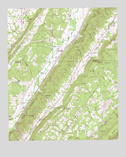
Keener, AL USGS Topographic Map
Click on map above to begin viewing in our Map Viewer.

This topographic map contains these locations and features:
Feature Name Type Latitude Longitude GNIS ID View Map
Big BranchStreamN34.1657°W85.8822°114235View Map
Birch Rock HollowValleyN34.1523°W85.8808°114362View Map
Black CreekPopulated PlaceN34.1759°W85.8777°149024View Map
Black Creek Missionary Baptist ChurchChurchN34.1795°W85.8797°114422View Map
Black Creek School (historical)SchoolN34.1795°W85.8805°149026View Map
Black Creek Volunteer Fire DepartmentBuildingN34.1670°W85.8952°2682823View Map
Boyd CemeteryCemeteryN34.2248°W85.8936°150120View Map
Bristow CemeteryCemeteryN34.1984°W85.9561°114925View Map
Bristow Methodist Episcopal Church (historical)ChurchN34.1979°W85.9566°149030View Map
Campbell GapGapN34.1673°W85.9580°115498View Map
Carter School (historical)SchoolN34.2498°W85.9830°1729834View Map
Chumley (historical)Populated PlaceN34.2145°W85.9483°163222View Map
Chumley BridgeBridgeN34.1893°W85.9627°116110View Map
Chumley MillLocaleN34.1893°W85.9625°140492View Map
Dark HollowValleyN34.2359°W85.9705°150183View Map
Dark Hollow BranchStreamN34.2134°W85.9483°150184View Map
Devil Den CoveValleyN34.1365°W85.8977°117246View Map
Duck SpringsPopulated PlaceN34.1459°W85.9991°155058View Map
Duck SpringsSpringN34.1529°W85.9933°140515View Map
Duck Springs Baptist ChurchChurchN34.1609°W85.9852°157938View Map
Duck Springs CemeteryCemeteryN34.1451°W85.9994°140516View Map
Duck Springs Covered Bridge (historical)BridgeN34.1540°W85.9847°149048View Map
Falls BranchStreamN34.1779°W85.8927°118183View Map
FlandersPopulated PlaceN34.2073°W85.9027°156356View Map
Flanders GapGapN34.1984°W85.8919°118355View Map
Flat Church BridgeBridgeN34.2137°W85.9486°150229View Map
Forney BranchStreamN34.1312°W85.9239°118510View Map
Gladden BranchStreamN34.1345°W85.9289°119013View Map
GreenwoodPopulated PlaceN34.1712°W85.9430°166207View Map
Greenwood Baptist ChurchChurchN34.1723°W85.9433°119387View Map
Greenwood CemeteryCemeteryN34.1723°W85.9430°140604View Map
Greenwood Post OfficePost OfficeN34.1712°W85.9430°169263View Map
Harbour CemeteryCemeteryN34.2098°W85.9047°150278View Map
HendrixvillePopulated PlaceN34.2184°W85.9494°150699View Map
Hendrixville Volunteer Fire DepartmentBuildingN34.2394°W85.9623°2683438View Map
Hog Pen BranchStreamN34.1295°W85.9241°120199View Map
John Gilbreath Number 1 DamDamN34.2118°W85.9233°150611View Map
John Gilbreath Number 1 LakeReservoirN34.2118°W85.9233°150610View Map
Jordan GapGapN34.2190°W85.8766°150311View Map
Jordan HillSummitN34.2270°W85.8866°150312View Map
KeenerPopulated PlaceN34.1562°W85.9511°121099View Map
Keener Baptist ChurchChurchN34.1557°W85.9522°140634View Map
Keener Elementary SchoolSchoolN34.1612°W85.9505°140635View Map
Keener GapGapN34.1551°W85.9341°121100View Map
Keener SpringSpringN34.1562°W85.9449°121101View Map
Keener Volunteer Fire DepartmentBuildingN34.1583°W85.9479°2683168View Map
Lick BranchStreamN34.1434°W85.9019°121585View Map
Little Sand Valley CreekStreamN34.1354°W85.9986°152112View Map
Lookout Mountain DivisionCivilN34.1315°W85.9243°165771View Map
Marcus (historical)Populated PlaceN34.2151°W85.9830°150717View Map
Marcus School (historical)SchoolN34.2137°W85.9975°1729836View Map
Mathis CemeteryCemeteryN34.2476°W85.9041°150374View Map
Mount Pleasant ChurchChurchN34.2493°W85.9808°150402View Map
Mountain View LakeReservoirN34.2347°W85.8772°150413View Map
Mud Spring BranchStreamN34.1354°W85.9061°123561View Map
New Home Missionary Baptist ChurchChurchN34.1279°W85.9061°123774View Map
New Hope Baptist ChurchChurchN34.1815°W85.9897°112863View Map
Nobe BranchStreamN34.2134°W85.9486°150431View Map
Patrick CemeteryCemeteryN34.1948°W85.9225°124480View Map
Patrick GapGapN34.1904°W85.9075°124482View Map
Pilgrims Rest Baptist ChurchChurchN34.1976°W85.8886°124745View Map
Pilgrims Rest CemeteryCemeteryN34.1979°W85.8880°164233View Map
Providence ChurchChurchN34.2201°W85.9522°158907View Map
Ray Smiths LakeReservoirN34.2068°W85.9433°150609View Map
Rocky Mount ChurchChurchN34.2343°W85.8789°150491View Map
Roden Baptist ChurchChurchN34.2326°W85.9714°158916View Map
Roden GapGapN34.2395°W85.9761°150493View Map
Smith DamDamN34.2068°W85.9433°150608View Map
Smiths Bridge (historical)Populated PlaceN34.1529°W85.9875°149119View Map
Smiths Bridge (historical)BridgeN34.1523°W85.9858°140723View Map
Spring BranchStreamN34.1454°W85.8939°149122View Map
Stephens BridgeBridgeN34.1534°W85.9850°127356View Map
Stephens GapGapN34.1493°W85.9761°127360View Map
Stillhouse HollowValleyN34.2162°W85.9022°150534View Map
TaborPopulated PlaceN34.1515°W85.9180°127629View Map
Tabor Missionary Baptist ChurchChurchN34.1515°W85.9189°140741View Map
Tabor School (historical)SchoolN34.1509°W85.9191°149125View Map
Tidwell GapGapN34.1782°W85.9177°127966View Map
Ward GapGapN34.2131°W85.9252°150576View Map
Ward HollowValleyN34.2023°W85.9158°150577View Map
Whitsnant HollowValleyN34.1837°W85.9719°150592View Map
Yancey SpringSpringN34.1715°W85.9764°140781View Map
YancyPopulated PlaceN34.1720°W85.9772°140780View Map

Note: Coordinates in the location and feature list above are referenced to NAD83 datum.


Copyright (C) 2008-2024 Ryan Niemi / Sunset Dynamics ... All Rights Reserved