TopoQuest Logo
Do you find TopoQuest useful?
Help keep TopoQuest running and adding new maps/features by donating!
Bitcoin:  19c7KJd3qBynnjoSw5npx9KScwjBe4ifkT
Litecoin:  LXs6TkuXGGXo1vDsWCkWVdjQX94eUKd6ui
Home View Maps Find Maps Find Places Resources & Links


Portersville, Alabama Topographic Map

USGS Map Title: Portersville, AL
USGS Map MRC: 34085C7
DRG (GeoTIFF) Download: o34085c7.tif


Neighboring USGS Topographic Map Quads:


  Fyffe, AL  
34085D8
 

  Chavies, AL  
34085D7
 

  Fort Payne, AL  
34085D6
 

  Crossville, AL  
34085C8
 

  Portersville, AL  
34085C7
 

  Little River, AL  
34085C6
 

  Keener, AL  
34085B8
 

  Leesburg, AL  
34085B7
 

  Centre, AL  
34085B6


Map MRC Location:

N35°
W86°
N35°
W85°
H8 H7 H6 H5 H4 H3 H2 H1
G8 G7 G6 G5 G4 G3 G2 G1
F8 F7 F6 F5 F4 F3 F2 F1
E8 E7 E6 E5 E4 E3 E2 E1
D8 D7 D6 D5 D4 D3 D2 D1
C8 C7 C6 C5 C4 C3 C2 C1
B8 B7 B6 B5 B4 B3 B2 B1
A8 A7 A6 A5 A4 A3 A2 A1
N34°
W86°
N34°
W85°

Portersville, AL USGS 1:24K Topographic Map Preview:
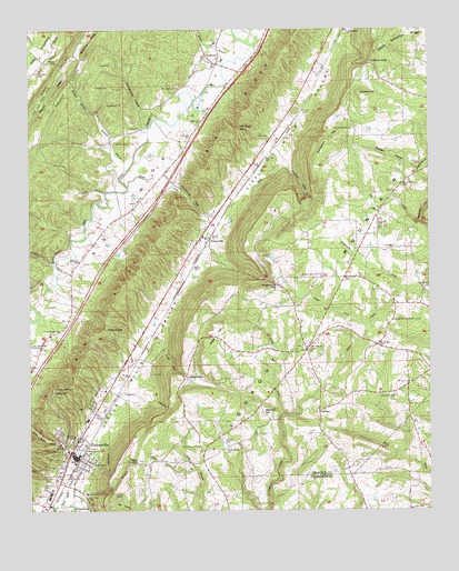
Portersville, AL USGS Topographic Map
Click on map above to begin viewing in our Map Viewer.

This topographic map contains these locations and features:
Feature Name Type Latitude Longitude GNIS ID View Map
Andrews Institute (historical)SchoolN34.3195°W85.8694°150647View Map
Anthony Collins CemeteryCemeteryN34.2812°W85.8675°150069View Map
Big RockPillarN34.2762°W85.7847°150108View Map
Big Rock ChurchChurchN34.2759°W85.7830°155966View Map
Big Valley Church of GodChurchN34.2812°W85.8515°2573702View Map
Brown Fell Community CenterLocaleN34.2993°W85.7614°150130View Map
Brown Fell School (historical)SchoolN34.2998°W85.7611°157518View Map
Campground HollowValleyN34.3501°W85.8389°150142View Map
Cherokee Mill (historical)LocaleN34.3334°W85.8483°150661View Map
Clayton CoveValleyN34.3409°W85.7947°150158View Map
Clyde (historical)Populated PlaceN34.3668°W85.8716°163223View Map
Collbran GapGapN34.3668°W85.7675°150161View Map
Collins CemeteryCemeteryN34.2665°W85.8630°150163View Map
CollinsvillePopulated PlaceN34.2640°W85.8605°150164View Map
Collinsville Baptist ChurchChurchN34.2654°W85.8625°150665View Map
Collinsville CemeteryCemeteryN34.2556°W85.8714°150165View Map
Collinsville High SchoolSchoolN34.2534°W85.8694°150666View Map
Collinsville Post OfficePost OfficeN34.2650°W85.8613°168385View Map
Collinsville Presbyterian ChurchChurchN34.2640°W85.8630°150668View Map
Collinsville Town Police DepartmentBuildingN34.2649°W85.8609°2751968View Map
Collinsville Volunteer Fire DepartmentBuildingN34.2642°W85.8608°2682712View Map
Dawson GapGapN34.3548°W85.8694°155575View Map
Devils Saltcellar RidgeRidgeN34.3738°W85.7605°150196View Map
Downer CemeteryCemeteryN34.3604°W85.8539°150201View Map
Drake HillRidgeN34.2965°W85.8180°150202View Map
Dry CreekStreamN34.3251°W85.7525°150203View Map
Dry PondLakeN34.3661°W85.8490°150205View Map
First United Methodist ChurchChurchN34.2618°W85.8636°1805691View Map
Franklin Academy (historical)SchoolN34.3243°W85.7755°150693View Map
Ginbelt HollowValleyN34.3406°W85.8466°150255View Map
Graham Chapel (historical)ChurchN34.3465°W85.7544°150761View Map
Hall CemeteryCemeteryN34.2856°W85.8372°150272View Map
Halls GapGapN34.2626°W85.8408°150273View Map
Horton BranchStreamN34.3668°W85.8119°150298View Map
Indian CreekStreamN34.2754°W85.7964°150302View Map
Kerley CemeteryCemeteryN34.2604°W85.8716°150314View Map
Kerley SpringSpringN34.2506°W85.8566°150315View Map
Killian CemeteryCemeteryN34.3470°W85.7997°150316View Map
Lackey CoveValleyN34.2956°W85.8344°150321View Map
Lackey GapGapN34.2848°W85.8264°150322View Map
Larimore (historical)Populated PlaceN34.3054°W85.8605°150706View Map
LebanonPopulated PlaceN34.3659°W85.8158°150330View Map
Lebanon ChurchChurchN34.3670°W85.8144°158287View Map
Longshore CemeteryCemeteryN34.2801°W85.7611°150354View Map
Longshore Mill (historical)LocaleN34.2801°W85.7647°150712View Map
LovelessPopulated PlaceN34.3179°W85.7622°150356View Map
Lykes CoveValleyN34.2787°W85.8430°152175View Map
McNutt Memorial Methodist ChurchChurchN34.3109°W85.7836°158867View Map
Mill Road GapGapN34.3493°W85.8089°150380View Map
Mitchell HillSummitN34.2756°W85.8027°150383View Map
Morgan GapGapN34.3668°W85.8658°150391View Map
Mount Lebanon ChurchChurchN34.3595°W85.8283°150396View Map
Mount VernonPopulated PlaceN34.2926°W85.7877°150406View Map
Mount Vernon CemeteryCemeteryN34.2923°W85.7894°1805468View Map
Mount Vernon ChurchChurchN34.2918°W85.7889°157529View Map
Mount Zion ChurchChurchN34.2831°W85.7566°150408View Map
Mush CreekStreamN34.3345°W85.8441°150414View Map
New Testament Holiness ChurchChurchN34.3279°W85.7980°159003View Map
Paley HillSummitN34.2812°W85.8677°150444View Map
Parrish BranchStreamN34.3390°W85.8436°150447View Map
Pine Grove (historical)Populated PlaceN34.2945°W85.7652°158179View Map
Plunket CemeteryCemeteryN34.2687°W85.8152°153022View Map
PortersvillePopulated PlaceN34.3212°W85.8208°153049View Map
Portersville GapGapN34.3084°W85.7972°150464View Map
Portersville GapGapN34.3293°W85.8250°150465View Map
Porterville ChurchChurchN34.3212°W85.8208°150736View Map
Red Hill Church (historical)ChurchN34.3170°W85.8733°150759View Map
Reed SpringSpringN34.2659°W85.8572°150479View Map
Ruhama ChurchChurchN34.3287°W85.7652°158296View Map
Shady Grove BranchStreamN34.2609°W85.8233°150505View Map
Shady Grove ChurchChurchN34.2665°W85.8227°150506View Map
Smith Chapel (historical)ChurchN34.2968°W85.8647°157538View Map
Smith Chapel (historical)ChurchN34.2659°W85.8136°157539View Map
Smith Chapel CemeteryCemeteryN34.2662°W85.8127°150517View Map
Smith Chapel CemeteryCemeteryN34.2962°W85.8652°150518View Map
Stapp CreekStreamN34.2976°W85.7694°150527View Map
Straight HollowValleyN34.3387°W85.7536°150539View Map
The FunnelBasinN34.3554°W85.8464°150549View Map
Thompson HillRidgeN34.3462°W85.7805°150553View Map
Town of CollinsvilleCivilN34.2670°W85.8653°2406296View Map
Trinity ChurchChurchN34.3493°W85.8400°150559View Map
Walnut Creek FarmsLocaleN34.3250°W85.8456°2711267View Map
Warren Stewart CemeteryCemeteryN34.3456°W85.8480°150579View Map
Wesson GapGapN34.2973°W85.8514°150583View Map
Willstown (historical)Populated PlaceN34.3709°W85.8152°158149View Map
Wooten HillSummitN34.3584°W85.7716°154035View Map

Note: Coordinates in the location and feature list above are referenced to NAD83 datum.


Copyright (C) 2008-2024 Ryan Niemi / Sunset Dynamics ... All Rights Reserved