TopoQuest Logo
Do you find TopoQuest useful?
Help keep TopoQuest running and adding new maps/features by donating!
Bitcoin:  19c7KJd3qBynnjoSw5npx9KScwjBe4ifkT
Litecoin:  LXs6TkuXGGXo1vDsWCkWVdjQX94eUKd6ui
Home View Maps Find Maps Find Places Resources & Links


Crossville, Alabama Topographic Map

USGS Map Title: Crossville, AL
USGS Map MRC: 34085C8
DRG (GeoTIFF) Download: o34085c8.tif


Neighboring USGS Topographic Map Quads:


  Grove Oak, AL  
34086D1
 

  Fyffe, AL  
34085D8
 

  Chavies, AL  
34085D7
 

  Painter, AL  
34086C1
 

  Crossville, AL  
34085C8
 

  Portersville, AL  
34085C7
 

  Rodentown, AL  
34086B1
 

  Keener, AL  
34085B8
 

  Leesburg, AL  
34085B7


Map MRC Location:

N35°
W86°
N35°
W85°
H8 H7 H6 H5 H4 H3 H2 H1
G8 G7 G6 G5 G4 G3 G2 G1
F8 F7 F6 F5 F4 F3 F2 F1
E8 E7 E6 E5 E4 E3 E2 E1
D8 D7 D6 D5 D4 D3 D2 D1
C8 C7 C6 C5 C4 C3 C2 C1
B8 B7 B6 B5 B4 B3 B2 B1
A8 A7 A6 A5 A4 A3 A2 A1
N34°
W86°
N34°
W85°

Crossville, AL USGS 1:24K Topographic Map Preview:
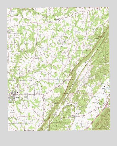
Crossville, AL USGS Topographic Map
Click on map above to begin viewing in our Map Viewer.

This topographic map contains these locations and features:
Feature Name Type Latitude Longitude GNIS ID View Map
Collinsville ChurchChurchN34.2923°W85.9244°158272View Map
Collinsville DivisionCivilN34.2666°W85.8773°165749View Map
Collinsville Industrial ParkLocaleN34.2668°W85.8944°150667View Map
Copeland BridgePopulated PlaceN34.2968°W85.8852°150167View Map
Copeland Bridge CemeteryCemeteryN34.2956°W85.8897°158273View Map
Cotnam (historical)Populated PlaceN34.2673°W85.9408°150671View Map
Cove HollowValleyN34.3440°W85.8833°150173View Map
CrossvillePopulated PlaceN34.2876°W85.9941°150178View Map
Crossville Fire DepartmentBuildingN34.2866°W85.9821°2682716View Map
Crossville High SchoolSchoolN34.2887°W85.9953°150673View Map
Crossville Post OfficePost OfficeN34.2874°W85.9811°168403View Map
Crossville Town Police DepartmentBuildingN34.2872°W85.9926°2752033View Map
Davis Chapel (historical)ChurchN34.3598°W85.9558°150760View Map
DawsonPopulated PlaceN34.3040°W85.9261°155048View Map
Dawson Post OfficePost OfficeN34.3056°W85.9253°2788978View Map
De Kalb Memorial GardensCemeteryN34.3145°W85.9980°150680View Map
Dugout ValleyValleyN34.3020°W85.9150°150207View Map
Edwards BridgeBridgeN34.2643°W85.9169°150217View Map
FairviewPopulated PlaceN34.3384°W85.9264°156337View Map
Fairview ChurchChurchN34.3309°W85.9244°150222View Map
Freeman CemeteryCemeteryN34.2918°W85.9241°150240View Map
Friendship ChurchChurchN34.3304°W85.9255°150242View Map
Gilbert CrossroadsPopulated PlaceN34.3620°W85.9355°156406View Map
Gilbreath CemeteryCemeteryN34.2709°W85.9419°150253View Map
Griffin FallsFallsN34.2874°W85.9304°150266View Map
Hayes GapGapN34.2593°W85.9550°150284View Map
Hendrickville (historical)Populated PlaceN34.2634°W85.9241°150698View Map
HighpointCapeN34.3431°W85.8866°150293View Map
Homer (historical)Populated PlaceN34.2634°W85.9072°150701View Map
Interchange 205CrossingN34.2751°W85.8791°155698View Map
Laurel CreekStreamN34.3515°W85.9386°150328View Map
Liberty Hill Baptist ChurchChurchN34.2973°W85.8852°158857View Map
Little Sand Valley CreekStreamN34.2665°W85.9172°150343View Map
Little Wills CreekStreamN34.2826°W85.8966°150349View Map
Lybrand BranchStreamN34.3156°W85.9466°150361View Map
Midway School (historical)SchoolN34.3720°W85.8947°1729838View Map
Mooney BranchStreamN34.3293°W85.9839°150386View Map
Mount Tabor ChurchChurchN34.3709°W85.9069°150404View Map
Mount Vera Church (historical)ChurchN34.2543°W85.9508°157669View Map
Mount Vera RidgeRidgeN34.2640°W85.9341°150405View Map
Mount Vera Volunteer Fire DepartmentBuildingN34.2624°W85.9358°2682749View Map
Nicholson (historical)Populated PlaceN34.3106°W85.9155°150730View Map
Nicholson CemeteryCemeteryN34.2679°W85.8975°150428View Map
Nicholson CemeteryCemeteryN34.3131°W85.9152°150429View Map
Nicholson GapGapN34.3115°W85.9208°150430View Map
Norris CemeteryCemeteryN34.3604°W85.9636°158291View Map
Nunn SpringSpringN34.3084°W85.8819°150432View Map
OphirPopulated PlaceN34.3601°W85.9455°156839View Map
Orphir School (historical)SchoolN34.3598°W85.9555°1729840View Map
Pilgrim Rest ChurchChurchN34.3634°W85.9641°152900View Map
Pleasant Hill CemeteryCemeteryN34.2898°W85.9155°1730574View Map
Pleasant Hill ChurchChurchN34.2901°W85.9152°150733View Map
Pleasant Valley ChurchChurchN34.2768°W85.9180°150734View Map
Red HillSummitN34.3248°W85.8764°150476View Map
Red Hill CemeteryCemeteryN34.3187°W85.8772°150477View Map
Ripshin RidgeRidgeN34.3270°W85.8927°150482View Map
Sand Mountain Agricultural Experment StationLocaleN34.2876°W85.9622°164412View Map
Sand ValleyValleyN34.2572°W85.9498°150501View Map
SkirumPopulated PlaceN34.3237°W85.9672°153465View Map
Skirum ChurchChurchN34.3243°W85.9708°150743View Map
Skirum Junior High School (historical)SchoolN34.3256°W85.9644°150762View Map
South Fork Scarham CreekStreamN34.3054°W85.9922°150523View Map
Swindell FallsFallsN34.2773°W85.9385°150544View Map
Tidmore SpringSpringN34.2998°W85.8850°150554View Map
Town of CrossvilleCivilN34.2853°W85.9996°2406341View Map
Union Grove Baptist ChurchChurchN34.2881°W85.9758°153783View Map
Union Grove CemeteryCemeteryN34.2884°W85.9752°1730313View Map
Vernon Baptist ChurchChurchN34.2543°W85.9094°158948View Map
Wallace BranchStreamN34.2762°W85.9269°150573View Map
Wesson CemeteryCemeteryN34.3181°W85.8766°150582View Map
West DamDamN34.3018°W85.9100°150612View Map
West LakeReservoirN34.3030°W85.9094°150613View Map
Wills (historical)Populated PlaceN34.3429°W85.9052°150756View Map

Note: Coordinates in the location and feature list above are referenced to NAD83 datum.


Copyright (C) 2008-2025 Ryan Niemi / Sunset Dynamics ... All Rights Reserved