TopoQuest Logo
Do you find TopoQuest useful?
Help keep TopoQuest running and adding new maps/features by donating!
Bitcoin:  19c7KJd3qBynnjoSw5npx9KScwjBe4ifkT
Litecoin:  LXs6TkuXGGXo1vDsWCkWVdjQX94eUKd6ui
Home View Maps Find Maps Find Places Resources & Links


Wilma, Florida Topographic Map

USGS Map Title: Wilma, FL
USGS Map MRC: 30084B8
DRG (GeoTIFF) Download: o30084b8.tif


Neighboring USGS Topographic Map Quads:


  Estiffanulga, FL  
30085C1
 

  Woods, FL  
30084C8
 

  Telogia, FL  
30084C7
 

  Orange, FL  
30085B1
 

  Wilma, FL  
30084B8
 

  Queens Bay, FL  
30084B7
 

  Kennedy Creek, FL  
30085A1
 

  Sumatra, FL  
30084A8
 

  Owens Bridge, FL  
30084A7


Map MRC Location:

N31°
W85°
N31°
W84°
H8 H7 H6 H5 H4 H3 H2 H1
G8 G7 G6 G5 G4 G3 G2 G1
F8 F7 F6 F5 F4 F3 F2 F1
E8 E7 E6 E5 E4 E3 E2 E1
D8 D7 D6 D5 D4 D3 D2 D1
C8 C7 C6 C5 C4 C3 C2 C1
B8 B7 B6 B5 B4 B3 B2 B1
A8 A7 A6 A5 A4 A3 A2 A1
N30°
W85°
N30°
W84°

Wilma, FL USGS 1:24K Topographic Map Preview:
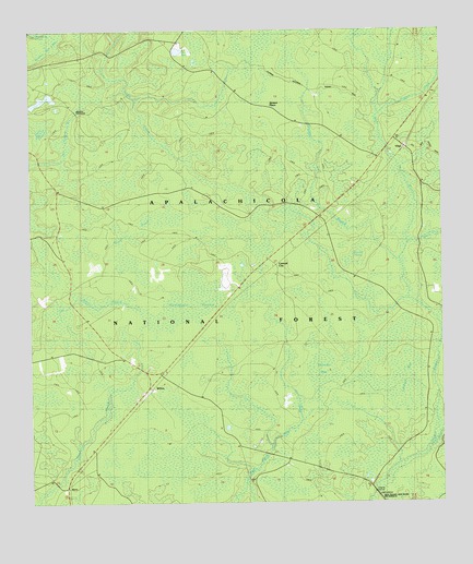
Wilma, FL USGS Topographic Map
Click on map above to begin viewing in our Map Viewer.

This topographic map contains these locations and features:
Feature Name Type Latitude Longitude GNIS ID View Map
Bay CreekStreamN30.1421°W84.8769°305240View Map
Bill Dick PondLakeN30.2447°W84.9547°305309View Map
Black CreekStreamN30.1924°W84.8857°305320View Map
Bracel BranchStreamN30.2321°W84.9685°306675View Map
Brushy CrossingLocaleN30.2283°W84.9857°305387View Map
Burnt BridgeBridgeN30.2110°W84.9844°305418View Map
Carr BridgeBridgeN30.1277°W84.8957°305451View Map
Central CityPopulated PlaceN30.1883°W84.9257°305469View Map
Cliff BridgeBridgeN30.1319°W84.9344°305492View Map
Devils Old Field SwampSwampN30.2241°W84.9964°305571View Map
Fillman Hill BaySwampN30.2464°W84.9942°305668View Map
Franklin PondLakeN30.2318°W84.9968°305704View Map
Glover HeadSwampN30.1890°W84.9031°305730View Map
Hogpen CreekStreamN30.2283°W84.8938°305820View Map
Hostage BranchStreamN30.1888°W84.8874°305837View Map
Jensen PlacePopulated PlaceN30.2302°W84.9269°305869View Map
KernPopulated PlaceN30.1299°W84.9888°305903View Map
Liberty CountyCivilN30.2414°W84.8829°308549View Map
Lindsey BaySwampN30.1560°W84.8866°305946View Map
Nixon Garden CemeteryCemeteryN30.2082°W84.9166°306113View Map
Ranger StationLocaleN30.1619°W84.9691°306268View Map
Rock PondLakeN30.1980°W84.9660°306301View Map
Thomas BaySwampN30.1592°W84.9129°306491View Map
Two Barrel BranchStreamN30.1737°W84.9908°305236View Map
VilasPopulated PlaceN30.2191°W84.8857°306543View Map
Whitehead SwampSwampN30.1785°W84.9513°306594View Map
WilmaPopulated PlaceN30.1544°W84.9644°306601View Map
Wilma Fire TowerTowerN30.1602°W84.9699°306602View Map
Wilma Work CenterLocaleN30.1630°W84.9682°308605View Map

Note: Coordinates in the location and feature list above are referenced to NAD83 datum.


Copyright (C) 2008-2024 Ryan Niemi / Sunset Dynamics ... All Rights Reserved