TopoQuest Logo
Do you find TopoQuest useful?
Help keep TopoQuest running and adding new maps/features by donating!
Bitcoin:  19c7KJd3qBynnjoSw5npx9KScwjBe4ifkT
Litecoin:  LXs6TkuXGGXo1vDsWCkWVdjQX94eUKd6ui
Home View Maps Find Maps Find Places Resources & Links


Kewanee, Mississippi Topographic Map

USGS Map Title: Kewanee, MS
USGS Map MRC: 32088D4
DRG (GeoTIFF) Download: o32088d4.tif


Neighboring USGS Topographic Map Quads:


  Lauderdale, MS  
32088E5
 

  Tamola, MS  
32088E4
 

  Boyd, AL  
32088E3
 

  Toomsuba, MS  
32088D5
 

  Kewanee, MS  
32088D4
 

  York, AL  
32088D3
 

  Vimville, MS  
32088C5
 

  Whynot, MS  
32088C4
 

  Ward, AL  
32088C3


Map MRC Location:

N33°
W89°
N33°
W88°
H8 H7 H6 H5 H4 H3 H2 H1
G8 G7 G6 G5 G4 G3 G2 G1
F8 F7 F6 F5 F4 F3 F2 F1
E8 E7 E6 E5 E4 E3 E2 E1
D8 D7 D6 D5 D4 D3 D2 D1
C8 C7 C6 C5 C4 C3 C2 C1
B8 B7 B6 B5 B4 B3 B2 B1
A8 A7 A6 A5 A4 A3 A2 A1
N32°
W89°
N32°
W88°

Kewanee, MS USGS 1:24K Topographic Map Preview:
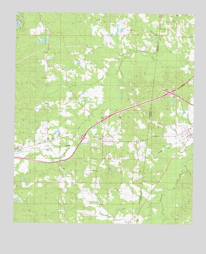
Kewanee, MS USGS Topographic Map
Click on map above to begin viewing in our Map Viewer.

This topographic map contains these locations and features:
Feature Name Type Latitude Longitude GNIS ID View Map
Bell Station (historical)LocaleN32.4790°W88.3884°134081View Map
Bethel CemeteryCemeteryN32.4496°W88.4597°666882View Map
Bethel Church (historical)ChurchN32.4501°W88.4598°683975View Map
Buddy Webb Pond DamDamN32.4185°W88.4950°681339View Map
CubaPopulated PlaceN32.4282°W88.3764°116945View Map
Cuba Elementary SchoolSchoolN32.4321°W88.3770°149773View Map
Cuba Post OfficePost OfficeN32.4291°W88.3768°168867View Map
Cuba Volunteer Fire Department Station 1BuildingN32.4292°W88.3794°2691163View Map
Cuba Volunteer Fire Department Station 2BuildingN32.4284°W88.3758°2691415View Map
Dalewood Shore LakeReservoirN32.4932°W88.4989°669079View Map
Dogwood Lake DamDamN32.4751°W88.4084°681418View Map
DovePopulated PlaceN32.4915°W88.3914°117438View Map
Ed Snow Lake DamDamN32.3868°W88.4984°681280View Map
Elizabeth ChurchChurchN32.4901°W88.4198°669721View Map
H A Pickett Lake DamDamN32.4285°W88.4684°681351View Map
Interchange 1CrossingN32.4532°W88.3920°155705View Map
Interchange 169CrossingN32.4257°W88.4520°691511View Map
Johnny Allen Pond DamDamN32.4535°W88.4517°681385View Map
K B Mitchell Pond DamDamN32.4851°W88.4034°681428View Map
Kelly CemeteryCemeteryN32.4246°W88.4764°672086View Map
KewaneePopulated PlaceN32.4240°W88.4384°691977View Map
Little Hope Baptist ChurchChurchN32.4199°W88.4978°672621View Map
Morning Star Baptist ChurchChurchN32.4910°W88.3948°158015View Map
Morning Star CemeteryCemeteryN32.4926°W88.3898°134194View Map
Morning Star Volunteer Fire DepartmentBuildingN32.4914°W88.3876°2691410View Map
Mrs Jack Morman Pond DamDamN32.4735°W88.4750°681416View Map
Mrs R E Payne Pond DamDamN32.4701°W88.4550°681412View Map
Pack CemeteryCemeteryN32.4729°W88.4278°675373View Map
Payne CemeteryCemeteryN32.4826°W88.4348°675517View Map
Pickfords Lake DamDamN32.4835°W88.4767°681427View Map
R B Lynch Catfish Ponds DamDamN32.4885°W88.4300°681429View Map
Roasted Hog CreekStreamN32.4689°W88.3836°125684View Map
Salem Baptist ChurchChurchN32.3774°W88.4300°677277View Map
Salem CemeteryCemeteryN32.3762°W88.4303°706402View Map
Salem CreekStreamN32.3882°W88.3981°126253View Map
Simmons Church (historical)ChurchN32.4885°W88.4620°684043View Map
SmithPopulated PlaceN32.4243°W88.4750°692235View Map
Spring Hill ChurchChurchN32.4065°W88.4431°678121View Map
Sucatolba CreekStreamN32.4665°W88.4270°678380View Map
Supervisor District 2CivilN32.4886°W88.4693°711939View Map
Sweet Pilgrim ChurchChurchN32.4610°W88.4781°678485View Map
Town of CubaCivilN32.4410°W88.3755°2406344View Map
W T Simmons Pond DamDamN32.4668°W88.4617°681405View Map

Note: Coordinates in the location and feature list above are referenced to NAD83 datum.


Copyright (C) 2008-2025 Ryan Niemi / Sunset Dynamics ... All Rights Reserved