TopoQuest Logo
Do you find TopoQuest useful?
Help keep TopoQuest running and adding new maps/features by donating!
Bitcoin:  19c7KJd3qBynnjoSw5npx9KScwjBe4ifkT
Litecoin:  LXs6TkuXGGXo1vDsWCkWVdjQX94eUKd6ui
Home View Maps Find Maps Find Places Resources & Links


Lauderdale, Mississippi Topographic Map

USGS Map Title: Lauderdale, MS
USGS Map MRC: 32088E5
DRG (GeoTIFF) Download: o32088e5.tif


Neighboring USGS Topographic Map Quads:


  Lauderdale NW, MS  
32088F6
 

  Oak Grove, MS  
32088F5
 

  Porterville, MS  
32088F4
 

  Daleville, MS  
32088E6
 

  Lauderdale, MS  
32088E5
 

  Tamola, MS  
32088E4
 

  Meridian North, MS  
32088D6
 

  Toomsuba, MS  
32088D5
 

  Kewanee, MS  
32088D4


Map MRC Location:

N33°
W89°
N33°
W88°
H8 H7 H6 H5 H4 H3 H2 H1
G8 G7 G6 G5 G4 G3 G2 G1
F8 F7 F6 F5 F4 F3 F2 F1
E8 E7 E6 E5 E4 E3 E2 E1
D8 D7 D6 D5 D4 D3 D2 D1
C8 C7 C6 C5 C4 C3 C2 C1
B8 B7 B6 B5 B4 B3 B2 B1
A8 A7 A6 A5 A4 A3 A2 A1
N32°
W89°
N32°
W88°

Lauderdale, MS USGS 1:24K Topographic Map Preview:
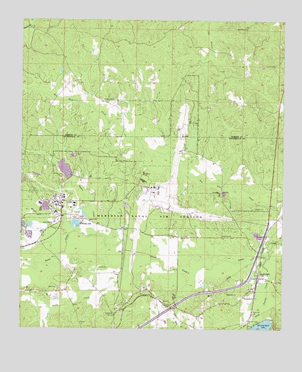
Lauderdale, MS USGS Topographic Map
Click on map above to begin viewing in our Map Viewer.

This topographic map contains these locations and features:
Feature Name Type Latitude Longitude GNIS ID View Map
Annette LakeReservoirN32.5487°W88.5964°683971View Map
Barrett CemeteryCemeteryN32.5371°W88.5442°666539View Map
Beatrice LakeReservoirN32.5468°W88.5948°683973View Map
Caroline LakeReservoirN32.5480°W88.6155°683979View Map
Charles Steele Pond DamDamN32.5018°W88.5917°681446View Map
Clayton CemeteryCemeteryN32.5246°W88.5878°668539View Map
Davis Mill (historical)LocaleN32.5287°W88.5078°683988View Map
First Baptist Church of LauderdaleChurchN32.5126°W88.5181°672318View Map
Gordon CemeteryCemeteryN32.5487°W88.5131°670534View Map
Helen LakeReservoirN32.5493°W88.6131°684001View Map
Holden Church (historical)ChurchN32.5160°W88.5673°684002View Map
Holiness ChurchChurchN32.5060°W88.5800°671288View Map
Kemper SpringsPopulated PlaceN32.5904°W88.5800°707970View Map
Kemper Springs Baptist ChurchChurchN32.5926°W88.5803°672094View Map
Lake Helen DamDamN32.5518°W88.6084°681494View Map
Lake Lucille DamDamN32.5735°W88.5450°681513View Map
LauderdalePopulated PlaceN32.5207°W88.5117°672316View Map
Lauderdale Census Designated PlaceCensusN32.5104°W88.5264°2586601View Map
Lauderdale Post OfficePost OfficeN32.5222°W88.5141°2768864View Map
Lauderdale United Methodist ChurchChurchN32.5207°W88.5103°711404View Map
Lauderdale Volunteer Fire and RescueBuildingN32.5036°W88.5163°2668028View Map
Little Reed CreekStreamN32.5040°W88.5134°672658View Map
Lost Horse CreekStreamN32.5318°W88.5750°672874View Map
Maftin C Tant LakeReservoirN32.5511°W88.6115°684009View Map
Martha LakeReservoirN32.5639°W88.6035°684008View Map
McElroys LakeLakeN32.5426°W88.5990°673344View Map
Meridian Naval Air Station /Mc Cain FieldAirportN32.5548°W88.5572°2676400View Map
Meridian Station Census Designated PlaceCensusN32.5485°W88.6092°2403278View Map
Moore CemeteryCemeteryN32.5162°W88.6075°673775View Map
Moores Mill (historical)LocaleN32.5571°W88.5286°684019View Map
Mount Olive ChurchChurchN32.5143°W88.5264°674134View Map
Naval Air Station MeridianMilitaryN32.5401°W88.5690°2512313View Map
Naval Air Station Meridian Fire Department HeadquartersBuildingN32.5568°W88.5623°2668020View Map
Naval Air Station Meridian Fire Department Station 2BuildingN32.5462°W88.6112°2667808View Map
Oak Grove ChurchChurchN32.5379°W88.5284°675041View Map
Oak Grove Church (historical)ChurchN32.5682°W88.5703°684023View Map
Pilgrim Rest ChurchChurchN32.6218°W88.5178°675749View Map
Pine Grove ChurchChurchN32.5138°W88.5623°675838View Map
Ponta (historical)LocaleN32.5376°W88.5598°684035View Map
Possum CreekStreamN32.5285°W88.5078°691602View Map
Segars CemeteryCemeteryN32.5435°W88.5923°677500View Map
Segars CreekStreamN32.5357°W88.5767°677501View Map
Sonny Montgomery Recreation ParkParkN32.5490°W88.6006°684044View Map
Soules ChapelChurchN32.5426°W88.6103°677989View Map
Wild Horse CreekStreamN32.5079°W88.6103°679673View Map
Wright CreekStreamN32.5382°W88.6020°679892View Map

Note: Coordinates in the location and feature list above are referenced to NAD83 datum.


Copyright (C) 2008-2024 Ryan Niemi / Sunset Dynamics ... All Rights Reserved