TopoQuest Logo
Do you find TopoQuest useful?
Help keep TopoQuest running and adding new maps/features by donating!
Bitcoin:  19c7KJd3qBynnjoSw5npx9KScwjBe4ifkT
Litecoin:  LXs6TkuXGGXo1vDsWCkWVdjQX94eUKd6ui
Home View Maps Find Maps Find Places Resources & Links


Whynot, Mississippi Topographic Map

USGS Map Title: Whynot, MS
USGS Map MRC: 32088C4
DRG (GeoTIFF) Download: o32088c4.tif


Neighboring USGS Topographic Map Quads:


  Toomsuba, MS  
32088D5
 

  Kewanee, MS  
32088D4
 

  York, AL  
32088D3
 

  Vimville, MS  
32088C5
 

  Whynot, MS  
32088C4
 

  Ward, AL  
32088C3
 

  Snell, MS  
32088B5
 

  Yantley, AL  
32088B4
 

  Lisman, AL  
32088B3


Map MRC Location:

N33°
W89°
N33°
W88°
H8 H7 H6 H5 H4 H3 H2 H1
G8 G7 G6 G5 G4 G3 G2 G1
F8 F7 F6 F5 F4 F3 F2 F1
E8 E7 E6 E5 E4 E3 E2 E1
D8 D7 D6 D5 D4 D3 D2 D1
C8 C7 C6 C5 C4 C3 C2 C1
B8 B7 B6 B5 B4 B3 B2 B1
A8 A7 A6 A5 A4 A3 A2 A1
N32°
W89°
N32°
W88°

Whynot, MS USGS 1:24K Topographic Map Preview:
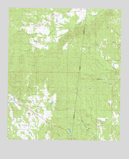
Whynot, MS USGS Topographic Map
Click on map above to begin viewing in our Map Viewer.

This topographic map contains these locations and features:
Feature Name Type Latitude Longitude GNIS ID View Map
AlamuchaPopulated PlaceN32.3588°W88.4686°691662View Map
Alamucha Volunteer Fire and Rescue DepartmentBuildingN32.3589°W88.4680°2668083View Map
Antioch CemeteryCemeteryN32.2574°W88.4553°666288View Map
Ben Dearman Catfish Ponds DamDamN32.2835°W88.4967°681160View Map
Bethany Baptist ChurchChurchN32.2876°W88.4823°666867View Map
Brunson ChurchChurchN32.3410°W88.3759°158799View Map
Chatham Pond DamDamN32.2501°W88.4834°681122View Map
Concord CemeteryCemeteryN32.2646°W88.4120°116481View Map
Dulls CemeteryCemeteryN32.3501°W88.3834°134128View Map
Green Hill ChurchChurchN32.3682°W88.4456°683999View Map
Liberty ChurchChurchN32.3379°W88.4156°121545View Map
Little Alamuchee CreekStreamN32.3557°W88.4345°672528View Map
Little CreekStreamN32.2696°W88.3878°140040View Map
McMurry CemeteryCemeteryN32.3476°W88.4750°673409View Map
Mount Zion Baptist ChurchChurchN32.3560°W88.4070°158032View Map
Mount Zion CemeteryCemeteryN32.3576°W88.3884°123422View Map
Old Antioch Church (historical)ChurchN32.2576°W88.4556°684028View Map
Pleasant Hill CemeteryCemeteryN32.2615°W88.4111°124974View Map
R Dempsey Lake DamDamN32.2635°W88.4384°681139View Map
Reeds Chapel Methodist ChurchChurchN32.3415°W88.4017°158910View Map
RosserLocaleN32.3132°W88.3778°134240View Map
Salem ChurchChurchN32.3201°W88.4717°677276View Map
Shamburger CemeteryCemeteryN32.3432°W88.3845°126625View Map
True Light ChurchChurchN32.2640°W88.3967°153727View Map
W D Reynolds Lake DamDamN32.2651°W88.4867°681146View Map
W E Harbor Pond DamDamN32.3585°W88.4500°681250View Map
W T Simmons Pond DamDamN32.3651°W88.4400°681259View Map
Watervalley ChurchChurchN32.2635°W88.4792°679372View Map
WhynotLocaleN32.2890°W88.4903°679661View Map
Whynot RacewayLocaleN32.2757°W88.4748°711334View Map
Zion Baptist ChurchChurchN32.3196°W88.3831°158106View Map

Note: Coordinates in the location and feature list above are referenced to NAD83 datum.


Copyright (C) 2008-2025 Ryan Niemi / Sunset Dynamics ... All Rights Reserved