TopoQuest Logo
Do you find TopoQuest useful?
Help keep TopoQuest running and adding new maps/features by donating!
Bitcoin:  19c7KJd3qBynnjoSw5npx9KScwjBe4ifkT
Litecoin:  LXs6TkuXGGXo1vDsWCkWVdjQX94eUKd6ui
Home View Maps Find Maps Find Places Resources & Links


Kibbie Lake, California Topographic Map

USGS Map Title: Kibbie Lake, CA
USGS Map MRC: 38119A7
DRG (GeoTIFF) Download: o38119a7.tif


Neighboring USGS Topographic Map Quads:


  Pinecrest, CA  
38119B8
 

  Cooper Peak, CA  
38119B7
 

  Emigrant Lake, CA  
38119B6
 

  Cherry Lake North, CA  
38119A8
 

  Kibbie Lake, CA  
38119A7
 

  Tiltill Mountain, CA  
38119A6
 

  Cherry Lake South, CA  
37119H8
 

  Lake Eleanor, CA  
37119H7
 

  Hetch Hetchy Reservoir, CA  
37119H6


Map MRC Location:

N39°
W120°
N39°
W119°
H8 H7 H6 H5 H4 H3 H2 H1
G8 G7 G6 G5 G4 G3 G2 G1
F8 F7 F6 F5 F4 F3 F2 F1
E8 E7 E6 E5 E4 E3 E2 E1
D8 D7 D6 D5 D4 D3 D2 D1
C8 C7 C6 C5 C4 C3 C2 C1
B8 B7 B6 B5 B4 B3 B2 B1
A8 A7 A6 A5 A4 A3 A2 A1
N38°
W120°
N38°
W119°

Kibbie Lake, CA USGS 1:24K Topographic Map Preview:
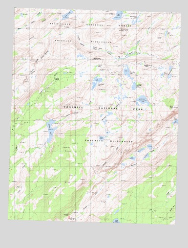
Kibbie Lake, CA USGS Topographic Map
Click on map above to begin viewing in our Map Viewer.

This topographic map contains these locations and features:
Feature Name Type Latitude Longitude GNIS ID View Map
Bartlett CreekStreamN38.0238°W119.8013°1652836View Map
Bartlett PeakSummitN38.0933°W119.7744°1658000View Map
Big LakeLakeN38.1224°W119.7978°256950View Map
Boundary LakeLakeN38.0886°W119.7897°257390View Map
Cherry RidgeRidgeN38.1223°W119.8435°258255View Map
East Fork Cherry CreekStreamN38.0983°W119.7902°266676View Map
Flora LakeLakeN38.0497°W119.8079°253468View Map
Gillett MountainSummitN38.1139°W119.7928°260565View Map
Hyatt LakeLakeN38.1214°W119.8362°261670View Map
Inferno LakesLakeN38.0868°W119.7590°261786View Map
Kendrick CreekStreamN38.0238°W119.8013°262126View Map
Kibbie LakeLakeN38.0538°W119.8459°262163View Map
Kibbie RidgeRidgeN38.0901°W119.8365°255086View Map
Little Bear LakeLakeN38.0808°W119.7847°262531View Map
Lord MeadowFlatN38.0980°W119.7910°252436View Map
Many Island LakeLakeN38.0827°W119.8128°263157View Map
Mercur PeakSummitN38.0958°W119.8162°1659110View Map
Nance PeakSummitN38.0691°W119.7551°1659202View Map
North Fork Cherry CreekStreamN38.0983°W119.7902°264149View Map
Pruitt LakeLakeN38.1123°W119.7619°265053View Map
Sachse SpringSpringN38.0810°W119.8455°252437View Map
Spotted Fawn LakeLakeN38.0728°W119.7777°267582View Map
Stanislaus-Yosemite Division (historical)CensusN38.0577°W119.8466°1935328View Map
Styx PassGapN38.0924°W119.8088°252438View Map
Twain Harte-Tuolumne City DivisionCivilN38.0703°W119.8540°1935352View Map
Yellowhammer LakeLakeN38.1195°W119.7844°269351View Map

Note: Coordinates in the location and feature list above are referenced to NAD83 datum.


Copyright (C) 2008-2024 Ryan Niemi / Sunset Dynamics ... All Rights Reserved