TopoQuest Logo
Do you find TopoQuest useful?
Help keep TopoQuest running and adding new maps/features by donating!
Bitcoin:  19c7KJd3qBynnjoSw5npx9KScwjBe4ifkT
Litecoin:  LXs6TkuXGGXo1vDsWCkWVdjQX94eUKd6ui
Home View Maps Find Maps Find Places Resources & Links


Cherry Lake South, California Topographic Map

USGS Map Title: Cherry Lake South, CA
USGS Map MRC: 37119H8
DRG (GeoTIFF) Download: o37119h8.tif


Neighboring USGS Topographic Map Quads:


  Hull Creek, CA  
38120A1
 

  Cherry Lake North, CA  
38119A8
 

  Kibbie Lake, CA  
38119A7
 

  Duckwall Mountain, CA  
37120H1
 

  Cherry Lake South, CA  
37119H8
 

  Lake Eleanor, CA  
37119H7
 

  Jawbone Ridge, CA  
37120G1
 

  Ascension Mountain, CA  
37119G8
 

  Ackerson Mountain, CA  
37119G7


Map MRC Location:

N38°
W120°
N38°
W119°
H8 H7 H6 H5 H4 H3 H2 H1
G8 G7 G6 G5 G4 G3 G2 G1
F8 F7 F6 F5 F4 F3 F2 F1
E8 E7 E6 E5 E4 E3 E2 E1
D8 D7 D6 D5 D4 D3 D2 D1
C8 C7 C6 C5 C4 C3 C2 C1
B8 B7 B6 B5 B4 B3 B2 B1
A8 A7 A6 A5 A4 A3 A2 A1
N37°
W120°
N37°
W119°

Cherry Lake South, CA USGS 1:24K Topographic Map Preview:
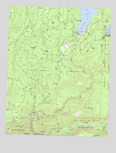
Cherry Lake South, CA USGS Topographic Map
Click on map above to begin viewing in our Map Viewer.

This topographic map contains these locations and features:
Feature Name Type Latitude Longitude GNIS ID View Map
Abernathy MeadowFlatN37.8752°W119.8993°256100View Map
Camp Forty ThreeLocaleN37.9733°W119.9602°257849View Map
Camp Fourty FourLocaleN37.9477°W119.9471°257850View Map
Cherry CreekStreamN37.8885°W119.9718°258242View Map
Cherry Valley CampgroundLocaleN37.9855°W119.9168°253023View Map
Cherry Valley DamDamN37.9762°W119.9092°258257View Map
Cottonwood CreekStreamN37.9774°W119.9188°258762View Map
Crane CreekStreamN37.9716°W119.9816°258872View Map
Crane MeadowFlatN37.9860°W119.9499°258876View Map
Dion R Holm PowerhouseLocaleN37.8966°W119.9688°1654887View Map
Early Intake 9-000 DamDamN37.8755°W119.9571°1663344View Map
Early Intake Powerhouse (historical)LocaleN37.8780°W119.9671°1654240View Map
Eleanor CreekStreamN37.9360°W119.8966°259827View Map
Granite CreekStreamN37.8885°W119.9716°260741View Map
Jawbone CreekStreamN37.8838°W119.9916°254835View Map
Jawbone StationLocaleN37.8999°W119.9999°253024View Map
Joes PointSummitN37.8852°W119.9546°1656101View Map
Jones PointSummitN37.8755°W119.9764°252476View Map
Jones Point Lookout (historical)LocaleN37.8763°W119.9768°262006View Map
Kelly FlatFlatN37.8896°W119.9649°262108View Map
Lake Eleanor 9-002 DamDamN37.9733°W119.8793°1663345View Map
Lake Eleanor CampgoundLocaleN37.9852°W119.8768°253025View Map
Lake Eleanor Ranger StationLocaleN37.9741°W119.8771°262288View Map
Lower Cherry Aqueduct (historical)CanalN37.8838°W119.9688°263010View Map
Meyers RanchLocaleN37.8960°W119.9918°263480View Map
Miguel CreekStreamN37.9538°W119.8813°263559View Map
North MountainSummitN37.9025°W119.8969°252464View Map
North Mountain Lookout (historical)LocaleN37.9027°W119.8980°264232View Map
Plum FlatFlatN37.9063°W119.9357°264861View Map
Preston FallsFallsN37.8844°W119.8813°252465View Map
Robert C Kirkwood PowerhouseLocaleN37.8780°W119.9518°1654888View Map
Skunk CreekStreamN37.9280°W119.9930°266245View Map
White Fir CreekStreamN37.9827°W119.9163°255231View Map
Wilson MeadowFlatN37.9610°W119.8982°269208View Map
Woods CreekStreamN37.9738°W119.9638°1652894View Map
Woods MeadowFlatN37.9552°W119.9580°1652871View Map
Woods RidgeRidgeN37.9593°W119.9688°269305View Map
Woods Ridge LookoutLocaleN37.9594°W119.9688°253026View Map

Note: Coordinates in the location and feature list above are referenced to NAD83 datum.


Copyright (C) 2008-2025 Ryan Niemi / Sunset Dynamics ... All Rights Reserved